👁 Image
| | Report (issue) | | BULLETIN 39
The Metal Resources of
New Mexico and
Their Economic
Features Through 1954
A revision of...RESOURCES
NEW MEXICO INSTITUTE OF MINING & TECHNOLOGY
CAMPUS STATION
SOCORRO, NEW MEXICO
�NEW MEXICO INSTITUTE...THE HONORABLE EDWIN L. MECHEM………...Governor of New Mexico
MRS. GEORGIA L. LUSK ......................Superintendent...Dealing With the Geology and Mineral Resources
of New Mexico ...................................................................... 4
METAL RESOURCES OF NEW MEXICO............................................. | 👁 Image
| | Journal (article/letter/editorial) | | leaf gold, smoky
quark, and turquoise specimens, New Mexico boasts an array of
mineral species.
RAMON S....Albuquerque, New Mexico 87110
THE PURPOSE OF THIS INDEX is to provide a comprehensive listing of New Mexico...Particular attention was
directed toward incorporating new information on discoveries and occurrences, although...to
compile all of the mineral occurrences in New Mexico-a
venture of that magnitude is beyond the scope...Minerals of New Mexico
is the basic reference for locations. Abstracts from the
New Mexico mineral symposia | 👁 Image
| | Report (issue) | | Idaho:
Volume III:
Miscellaneous Properties,
Owyhee County, Idaho
Earl H. Bennett, John Kauffman, and
Victoria...Idaho:
Volume III:
Miscellaneous Properties,
Owyhee County, Idaho
Earl H. Bennett, John Kauffman,
and Victoria... . . . 11
2.0 MISCELLANEOUS PROPERTIES, OWYHEE COUNTY, IDAHO . . . . . . . . . . . . . . . . . 12
2.1.... . . . . . . . 12
2.1.1 Summary of the Owyhee County Study Area . . . . . . . . . . . . . . . . . ..... . . . . . . . . 21
2.5 SUMMARY OF THE OWYHEE COUNTY STUDY AREA . . . . . . . . . . . . . . . . . 24 | 👁 Image
| | Report (issue) | | WEST-CENTRAL ARIZONA AND PART OF SAN BERNARDINO COUNTY, CALIFORNIA
�DEPARTMENT OF THE INTERIOR
MANUEL...west-central Arizona and part
of San Bernardino County, California ; en. E) (U.S. Geological Survey bulletin...Disseminated uranium, thorium, and rare-earth elements in granite
E20
Pegmatite minerals and vein tungsten
E21
Volcanogenic...and for gold
and minor silver in shear zones in granite. There is moderate
resource potential for gold...gold and minor silver in shear zones in
granite; for epithermal veins of silver, gold, lead, and zinc
Manuscript | 👁 Image
| Todd, V.R.; Kilburn, J.E.; Detra, D.E.; Griscom, A.; Knepper, D.H.; Krues, F.A.; Gather, E.; Lipton, D.A. (1987) Mineral resources of the Sawtooth Mountains and Carrizo Gorge/Eastern McCain Valley Wilderness Study Areas, San Diego County, California. Bulletin 1711b. US Geological Survey 26 pp. doi:10.3133/b1711b | Report (issue) | | McCain Valley Wilderness Study Areas,
San Diego County, California
U.S. GEOLOGICAL SURVEY BULLETIN 1711-B...(CA-060-024B) Wilderness Study Area, San Diego County, California
and for the Carrizo Gorge/Eastern McCain...(CA-060-025A) Wilderness Study Area,
San Diego County, California.
��CONTENTS
Summary Bl
Abstract 1...McCain Valley Wilderness Study Areas, San Diego County, California B2
Map showing generalized geology...Sawtooth Mountains Wilderness Study
Area, San Diego County, California 4
Map showing mineral resource potential | 👁 Image
| Theodore, Ted G., Blair, Will N., Nash, J. Thomas, McKee, E.H., Antweiler, J.C., Campbell, W.L. (1987) Geology and gold mineralization of the Gold Basin-Lost Basin mining districts, Mohave County, Arizona, with a section on K-Ar chronology of mineralization and igneous activity, and a section on implications of the compositions of lode and placer gold. Professional Paper 1361. US Geological Survey doi:10.3133/pp1361 | Report (issue) | | Gold Basin-Lost Basin Mining Districts,
Mohave County, Arizona
U.S.
GEOLOGICAL SURVEY PROFESSIONAL PAPER...GOLD BASIN-LOST BASIN MINING DISTRICTS,
MOHAVE COUNTY, ARIZONA
�Placer gold nugget about 1 cm wide showing...from King Tut placer
workings, Lost Basin mining district.
�Geology and Gold Mineralization of the
Gold...Gold Basin-Lost Basin Mining Districts,
Mohave County, Arizona
By TED G. THEODORE, WILL N. BLAIR, and J...Gold Basin-Lost Basin mining districts, Mohave County, Arizona.
(U.S. Geological Survey Professional | 👁 Image
| | Report (issue) | | National Forest: Volume
I: Atlanta Area, Elmore County, Idaho
John Kauffman
Ted Erdman
Earl H. Bennett...National Forest: Volume
I: Atlanta Area, Elmore County, Idaho
John Kauffman
Ted Erdman
Earl H. Bennett... .... . .. . ... . 11
2.0 ATLANTA AREA, ELMORE COUNTY, IDAHO ............ .................. 13
2.1 INTRODUCTION....... .... .. 27
3.0 ATLANTAMINING AREA, ELMORE COUNTY, IDAHO-MINE
DESCRIPTIONS ......................................... .. ..... 50
3.3 UNNAfvffiD PROSPECTS (Site Nos. HA-1264 [Field Site No. E7260101]
and | 👁 Image
| | Report (issue) | | in 1874 at Mauch
Chunk (now Jim Thorpe), Carbon County, Pa. ('Genth,
1875, p. 144B). In 1898 a deposit...vanadiferous sandstone was found at Roc Creek, Montrose County, Colo. This deposit was soon exploited for
the...but some came from Arizona and a little from
New Mexico.
The stimulus of the U.S. Atomic Energy Commission...Uranium
minerals
Sources of data
ARIZONA
Apache County
Jerome Chee prospect_ __________ Morrison 1_____...Carbonized logs and other
C-1, V-1, V-s_
Sab Tab, and unnamed
sandstone and greenishplant remains abundant.
mines | 👁 Image
| | Report (issue) | | MOUNTAINS WILDERNESS STUDY AREA (CDCA-334),
RIVERSIDE COUNTY, CALIFORNIA
SUMMARY REPORT
By
Robert E. Powell...California
Desert Conservation Area, Riverside County, California.
SUMMARY
Geologic, geochemical, and...geophysical investigations and a survey of
mines and prospects indicate that those parts of the Eagle Mountains...are abundant and accessible outside the area. No new mineral occurrence was
located during this study...Geological Survey and an investigation of mines,
prospects, and mineralized areas by the U.S. Bureau of Mines | 👁 Image
| Matti, Jonathan C., Cox, B.F., Rodriguez, Eduardo A., Obi, Curtis M., Powell, R.E., Hinkle, M.E., Griscom, Andrew, Sabine, Charles, Cwick, Gary J. (1982) Mineral resource potential map of the Bighorn Mountains Wilderness Study Area (CDCA-217), San Bernardino County, California. Open-File Report Vol. 1982 (82-962) US Geological Survey doi:10.3133/ofr82962 | Report (issue) | | WILDERNESS STUDY AREA (CDCA-217),
SAN BERNARDINO COUNTY, CALIFORNIA
p C.200)
SUMMARY REPORT
per, 2,2...California Desert Conservation Area, San Bernardino
County, California.
SUMMARY
Geological, geochemical, and...study area in the vicinity of the 7,500-ft-high Granite
Peaks. Access to the study area is gained by numerous...area from State Highway 247, and northward from New Dixie
Mine Road and Viscera Spring Road.
Prebatholithic...southwestern part of the
study area in the vicinity of Granite Peaks. This assemblage
consists mainly of biotite | 👁 Image
| | Report (issue) | | of Arizona showing physiographic provinces and
county boundaries --------------------------------------2-23...Survey
(USGS) in Reston, Va. The data are dynamic; new
information is added as it becomes available, and...first-time look at the mineral deposits within
a new study area, and to serve as a research tool for
compiling...so records with older district names have
been changed to conform with these new names.
Several fields...with no
entry for deposit name were designated "unnamed
deposit." Deposits without a yes or no production | 👁 Image
| Hargrave, P., Kerschen, M., McDonald, C., Metesh, J.J., Norbeck, P.M., Wintergerst, R. (2000) Abandoned-inactive mines program, Gallatin National Forest, administered lands. Open-File Report 418. Montana Bureau of Mines and Geology | Report (issue) | | Abandoned-inactive mines in the Gallatin Ranger District.
TheupperJohnsonCanyonadit
ThelowerJohnsonCanyonadit...at the Galena Queen.
13. The Big Timber Ranger District
14. TheKellyaditintheCrazyMountains
15. The site...McLaren tailings have beenincluded in the New World mining district.
Theupstreamsamplesite(SMTS10H)
In contrast...objectives, the MBMG objectives also included gathering new
information on the economic geology and hydrogeology...(USGS)],
3) published compilations of mines and prospects data,
4) state publications on mineral deposits | 👁 Image
| | Journal (issue) | | rock types, although almost all species are from granite
pegmatite. Many additional names have been proposed...in the Penrose
Branch of the Pikes Peak Library District (PPLD), in Colorado
Springs, Colorado. (See Exhibit...on page 4)
�Mineral News
----2
Newry, Oxford County, Maine
(Continued from page 1)
For example. chemical...Prospect, Martin
Prospect, Blue Pit. and several unnamed prospects. The Crooker
and Dunton Pegmatites are very...Perham Prospect. Swett
Prospect and several unnamed prospects. The Main Pegmatite is
actually divided by | 👁 Image
| | Report (issue) | | (Primitive Area and Adjacent Roadless Areas),
Silver Bow County, Montana
By
Harry W. Smedes, and William F. Hanna...the Humbug Spires Instant Study Area, Silver Bow County, Montana.
�Contents
Page
Geology and geochemical................................
15
Mines and prospects of the Humbug Spires Instant Study Area
by Michael................................
16
Mines and prospects.................................................showing locations of current claims and unnamed and
named prospects in and adjacent to the Humbug Spires | 👁 Image
| | Journal (article/letter/editorial) | | omitted from locality
information. Where lot and district numbers are given, it is
necessary to use topographic...Occurrence in
Carroll County, Georgia" (November/December 1988).
Banks County
184
ROCKS & MINERALS...provided many of the photographs.
Baldwin County
Milledgeville district—between the State Sanitarium and
the...pit—east of S.R. 243 near the Baldwin-Wilkerson
County line: kaolinite (Martin and Stafford, 1972).
Cheatham...property—Route 3, Commerce, 4.8 km from the
�Jackson County line, 8 km east of Commerce on S.R. 59,
and 0.8 | 👁 Image
| | Report (issue) | | the current-year issues of the monthly catalog "New Publications of the U.S. Geological Survey." Prices...Alaska Distribution Section, U.S. Geological Survey,
New Federal Building - Box 12
101 Twelfth Ave., Fairbanks... Bldg. 810, Federal
Center
• FAIRBANKS, Alaska--New Federal Bldg., 101 Twelfth Ave.
�Chapter G
Mineral...resources in these areas are subeconomic. Copper prospects in Tertiary conglomerates and mudstones west of...area on the fringe of the Lincoln Ranch mineral district.
The deposits in both areas are too thin and too | 👁 Image
| | Report (issue) | | INTERIOR
GEOLOGICAL SURVEY
MINERAL RESOURCES OF ELKO COUNTY, NEVADA
By
Roscoe M. Smith
Prepared in cooperation...Alder district-19
Aura district -21
Beaver district
25
Black Mountain district
27
Bootstrap district
27...27
Burner district
28
Burns Basin district-- -- 30
Carlin district
32
Cave Creek district
----- 35
Charleston...Coal Mine district~ 38
Contact district
- 39
Cornucopia district - -45
Corral Creek district
- - 48
Decoy...Decoy district
48
Delano district
49
Delker district53
Divide district
- - 54
Dolly Varden district
--54 | 👁 Image
| | Report (issue) | | NEW MEXICO
BUREAU OF MINES AND MINERAL RESOURCES
A DEPARTMENT OF THE SCHOOL OF MINES
E. C. ANDERSON...B U L L E T I N
2 1
Fluorspar Resources of New Mexico
By
HOWARD E. ROTHROCK, C. H. JOHNSON, AND
A....SOCORRO
1946
�THE NEW MEXICO BUREAU OF MINES AND
MINERAL RESOURCES
The New Mexico Bureau of Mines and...Resources, designated as "a
department of the New Mexico School of Mines and under the direction of its...its Board of
Regents," was established by the New Mexico Legislature of 1927. Its chief functions
are | 👁 Image
| Kerschen, M.D., Hargrave, P., McDonald, C., Metesh, J.J., Wintergerst, R. (2000) Abandoned-inactive mines program, Custer National Forest, administered lands. Open-File Report 421. Montana Bureau of Mines and Geology | Report (issue) | | . . . . . . . . . . 59
12. Typical bulldozer prospects in the Slim Buttes . . . . . . . . . . . . . .... . . . . . . . . . . . . . . . . . . 72
19. Prospects and mines located in the Pryor Mountains. . ..... . . . . . . . . . 74
20. Typical bulldozer prospects in the Pryor Mountains . . . . . . . . . . . ...Operation. . . . . . . . . . . . . . . . . . . 51
19. Prospects and exploration cuts concentrations . . . . .... . . . . . . . . . . . 69
21. Pryor Mountain prospects uranium concentrations . . . . . . . . . . . | 👁 Image
| | Report (issue) | | mining district ......................................................
Pamlico mining district .........mining district ......................................................
Pamlico mining district .........of the Lucky Boy mining district
2. Geologic map of the Pamlico mining district
�ABSTRACT
Mineral deposit...magmatic arc include W skarns (Gardnerville mining
district), W veins, a low-F porphyry Mo deposit (Pine Nut...Gardnerville mining district),
and Au-Cu quartz-tourmaline veins (Peavine mining district). Tertiary deposits | 👁 Image
| | Report (issue) | | 31
University of Nevada Press, Reno, Nevada 89557 USA
Copyright © 2004 by University of Nevada Press
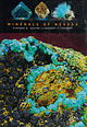
Photographs...6-cm cluster, Majuba Hill Mine, Antelope district, Pershing County.
N. Prenn collection. Photograph by J...
The Goodsprings (Yellow Pine)
Mining District, Clark County
John C. Kepper
91
References
467
Contributors...Nightingale district
Quartz epimorph after Calcite
Agardite
Grossular, Buena Vista district
Quartz (amethyst)...Smithsonite
Calcite, Getchell Mine
Robinson district
Sonoraite
Aurichalcite with
Hemimorphite
Azurite | 👁 Image
| | Report (issue) | | Ranges, Cedar
Mountain, and the Pilot Mountains. Granite porphyries occur in the San
Antonio Range, Rock...Range.
Intrusions of mid-Tertiary age occur as granite and granodiorite in the
Toiyabe and Toquima ranges...type. In addition, mineralization in the Reveille District may
represent the silver-rich end memeber of this...1972, Geology and mineral deposits of
Esmeralda County, Nevada: Nevada Bureau of Mines and Geology Bulletin...mineralization in the Battle
Mountain mining district, Lender County, Nevada, ^n_ Ridge, J.D., ed.,
papers on | 👁 Image
| | Report (issue) | | Volume II:
Flint Creek-South Mountain Area,
Owyhee County, Idaho
Earl H. Bennett, John Kauffman, and
Victoria...Volume II:
Flint Creek-South Mountain Area,
Owyhee County, Idaho
Earl H. Bennett, John Kauffman, and
Victoria.... . . . . . . . . . . . . . . . . . . 42
3.48 UNNAMED PROSPECT (Site No. JV-16).. . . . . . . . . . ... . . . . . . . . . . . . . . . . . . 108
3.60 UNNAMED PROSPECT (Site No. B7229901). . . . . . . . . ...the Flint Creek and South Mountain areas, Owyhee County,
Idaho (Ekren and others, 1981)... . . . . . . | 👁 Image
| | Report (issue) | | ..... . . ............ 10
Pike National Forest
County of El Paso (Black Forest) Land Exchange Offer ....... 51
Fig. 17. Map 15-Offered mining claims-Granite Mountain area
(provided by USFS) ................23. Attachment C. Table of mines, claims, and prospects (from
Gaskill and others, 1991) ..................... 64
Fig. 27. Attachment G. MRDS DC01142: unnamed site ........... 66
Fig. 28. Attachment H. Geologic...Attachment II. Geologic map of the northern Tomichi district
(Dings and Robinson, 1957) ............... 1' | 👁 Image
| | Report (issue) | | and Butler Wash Wilderness
Study Areas, San Juan County, Utah
U.S. GEOLOGICAL SURVEY BULLETIN 1754-A
...and Butler Wash Wilderness
Study .Areas, San Juan County, Utah
By CHARLES G. PATTERSON, MARGO I. TOTH,
JAMES...and Butler Wash
Wilderness study areas, San Juan County, Utah.
(Mineral resources of wilderness study areas...Wash (UT-060-169) Wilderness Study
Areas, San Juan County, Utah.
��CONTENTS
Abstract
Al
Summary
Al
Introduction...mineral resource potential, geology, and mines and prospects of
the Indian Creek, Bridger Jack Mesa, and Butler |
|
