👁 Image
| | Report (article/chapter) | | offshore igneous activity to the northwest of the
UK and its relationship to the North Atlantic Igneous...Murchison House,
West Mains Road, Edinburgh EH9 3LA, UK
Abstract: Offshore occurrences of Early Tertiary...(1) Faeroe Plateau Lava Group; (2) North Rockall
Trough-Hebrides Lava Group; (3) central igneous complexes;... St Kilda, Rockall). Exceptions to this trend
(i.e. Rosemary Bank, Anton Dohrn, Hebrides Terrace) are...genetically linked to crustal
thinning in the Rockall Trough. The age of the Faeroe Plateau Lava Group | 👁 Image
| | Report (issue) | | 997{10.020
Z=2
X-ray Powder Pattern: Rockall Island, Scotland.
3.80 (100), 2.800 (100), 5.85 (35), 3...
100.01
100.45
100.00
26.98
(1{2) Rockall Island, Scotland; by electron microprobe. (3) BaZrSi3 O9...interstitial mineral in aegirine-riebeckite granite (Rockall Island,
Scotland); in granular celsian-bearing rocks...rocks near contacts with granite (Big Creek, California,
USA).
Association: Elpidite, aegirine, albite,...pyrochlore, xenotime, barite, titanite (Rockall Island, Scotland); taramellite,
celsian, diopside, actinolite | 👁 Image
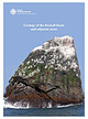
| | Report (issue) | | Cover The picture shows the south face of Rockall
Island which lies 162. 7 nau tical 1niles west of...Sr Kilda in rhe
north-east Arlanl'ic Ocean. The island is approximarely 18 1n
high and has a 1naximum...east-north-east intrudes the lower part of the
island. It is of a similar granitic composition and, on...the
sourh face ' can be seen ro bifurcate . T he island is cur bv
., a
series of joints, one set of which...associated geophysical anomalies, suggests
that Rockall was once part of a large volcano probably active | 👁 Image
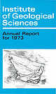
| | Report (issue) | | GEOLOGICAL SCIENCES
Report No. 75/1
Expeditions to Rockall 1971-72
Edited by R. K. Harrison, MSc
London:...HARRISON, R. K. (Editor). 1975. Expeditions to Rockall 1971-72.
Rep. Inst. Geol. Sci., No. 75/1. 72 pp...�PREFACE
Though a minute island situated in a hostile environment, Rockall is of considerable
scientific...largest microcontinent
in the North Atlantic, the Rockall Plateau. Our knowledge of this immense area is...from the participation in three cruises to Rockall Island in June 1971 and June 1972, by
officers drawn | 👁 Image
| | Journal (article/letter/editorial) | | intimate relationship of contaminated gabbro, granite and hybrid rock in the
prominent gully on the north-west...iu Alttv.liu
G.rs-bheiM sf II
Rfng fucrite .nd Outer G.bbrol:dou fndiute ott-er g.btrOI
Ttrti.ry l.yU...DYKES
CREAG STROLLAMUS GRANITE
COMPOSITE and ACID SILLS
BEINN NA CAILLICH GRANITE
BEINN NA CAILLICH VENT...KllCHRIST HYBRIDS
BEINN AN DUBHAICH GRANITE'
ALLT FEARNA GRANITE'
BEINN NA CROGRANITEJ
GLAS BHEINN MHOR...MHAOIL VENT)
DYKES
BLAVEN GRANITE
SRATH NA
CREITHEACH CENTRE MEALL DEARG GRANITE'
RUADH STACGRANITEl
LOCH | 👁 Image
| | Report (article/chapter) | | and complexity of igneous activity. Much of the
island is covered with lavas (basalts, mugearites
and...obtained (Dickin 1981) for the Coire Uaigneich
granite, one of the last intrusions of the Cuillins
centre...Tertiary igneous rocks
occupy the southern half of the island and consist
of a central intrusive complex, lavas...isochron date of 60.3 +
0.8 Ma for the northern granite was obtained by
Dickin et al. (1981), confirming...- R is
suggested for Arran, with the northern granite
and the quartz porphyry intrusions in the same | 👁 Image
| | Report (issue) | | Kingdom Offshore Regional Report
The geology of the Hebrides and est
Shetland shelves, and adjacent deep-water...Kingdom offihore regional report: the geology ofthe Hebrides
and West Shetland shelves, and adjacent deep-water...Other basins on the Hebrides Shelf 50
Other basins on the West Shetland Shelf 51
Rockall Trough-Faeroe-Shetland...68
Anton Dohrn 68
Rosemary Bank 69
Rocl...The Hebrides and West Shetland shelves 7
Coastal areas 7
Inner shelf and offshore islands 7
Outer shelf | 👁 Image
| Young, B. R., Hawkes, J. R., Merriman, R. J., Styles, M. T. (1978) Bazirite, BaZrSi3O9, a new mineral from Rockall Island, Inverness-shire, Scotland. Mineralogical Magazine, 42 (321) 35-40 doi:10.1180/minmag.1978.042.321.04 | Journal (article/letter/editorial) | | BaZrSi309, a new mineral from
Rockall Island, Inverness-shire, Scotland
B. R. YOUNG, J. R. HAWKES, R....minerals present in the aegirine-riebeckite
granite of Rockall Island. Crystals are hexagonal, probably gin2... Related minerals, benitoite and pabstite.
ROCKALL ISLAND (57 ~ 36' N.; I3 ~ 4I' W.),
an isolated pinnacle...pinnacle of Eocene aegirine-riebeckite
granite, is situated in the North Atlantic approximately 294 km...Invernessshire. Despite problems of access, the island has
been a focus of scientific interest since the | 👁 Image
| | Journal (article/letter/editorial) | | Notices of Memoirs—Notes on Rockall Island and Bank.
163
Okeford Fitzpaine, Dorset.1 The proof which...coast, 290 miles
away from the nearest point of Scotland, and 170 miles from
St. Kilda. It is only about...lighthouse or a meteorological
NOTES ON EOOKALL ISLAND AND BANK.
1
1
GEOL. MAG., Dec. IV, Vol. Ill...1017/S0016756800143006
�164
Notices of Memoirs—Notes on Rockall Island and Bank.
station. But minute as it is in...was effected during the recent investigation
of Rockall, the exploring party managed to secure a number | 👁 Image
| | Report (issue) | | •
•
Photographic Department at Leeds
•
•
•
•
•
Scotland
South Lowlands District •
•
•
•
•
•
•
North Lowlands...000 ft.
Gravity survey by helicopter in northern Scotland.
2, 3. Hoisting and lowering the 10-ton charge...3. Availability of one-inch geological maps of Scotland
Availability of one-inch geological maps of Northern...Sea oil reserves all three
land field units in Scotland have been called upon to advise the Scottish
Development...underground
storage in coastal areas. In the south of Scotland the continued planning
of the development of the | 👁 Image
| | Report (issue) | | I .
•
•
•
.
.
•
Leeds Drawing Office .
•
•
•
.
Scotland
•
•
•
South Lowlands District .
.
.
.
•
•
.
....Plate 5 •
•
•
•
•
•
•
•
Underwater photographs of Rockall Bank from
the Vickers submersible Pisces III.
...over travertine-covered bedded lime
stones on the island of Small Malaita, British
Solomon Islands Protectorate...Availability of one-inch geological maps of
•
•
•
Scotland •
•
•
•
•
Fig. 4. Availability of one-inch geological...predicted, to be caused by a granite, now called the Wensleydale
Granite, which was reached at a depth | 👁 Image
| | Report (issue) | | District .
•
•
•
•
.
.
.
•
Leeds Drawing Office
•
•
•
Scotland
•
Highlands and Islands District .
•
•
•
•
.
•...dolerite dyke on the north coast of Tohua
Island, Duff Island, British Solomon Islands.
A coal seam in...of depth charges from RRS
Challenger north of Scotland on the continental shelf.
•
.
.
.
Plate 12 .
...I :50 000 geological
.
.
.
.
.
.
1 64
maps of Scotland .
Fig. 3. Availability of one-inch and 1 :50 000...possibilities of the Lower Carboniferous oil--shales of
Scotland and the oil-shale horizons in the Jurassic Kimmeridge | 👁 Image
| | Report (article/chapter) | | in the southern part of the Outer
Moray Firth Basin, off eastern Scotland (Fig.
3A); thin representatives...samples indicates that they extend
throughout the UK sector (see Fig. 3B), being
most abundant in northern...sand
unit, showing typical wireline log responses (UK WeU
21/2-1).
Composition. The few mineralogical...available indicate that the North Sea and onshore
UK ashes include basaltic and more silicic types;
the...Sea: UK Well 16/7-2; south-western North Sea: BGS Borehole 81/46A (Lott et
al. 1983); onshore UK : BGS | 👁 Image
| | Catalog/List | | National Grid, each designated by a let ter. For the
UK, a false origin (0) is taken at the south-west
corner...of England and Wales, and a geothermal map of the UK are
listed under Hydrogeological Maps.
Some of the...titles are listed
below, with ISBN references.
Scotland
I*
2
3
4
5
6
Orkney and Shetland. W. Mykura...11880155 4) Out of. print.
The Midland Valley of Scotland. I. B. Cameron and D.
Stephenson (Edition 3,1985)...1985) (0 11 884365 6) £5
The South of Scotland. D. C. Greig and others (Edition
3, 1971) (11 880152 X) | 👁 Image
| | Report (volume) | | 1998. Debris flows on the Sula Sgeir Fan, NW of Scotland.
In: STOKER, M. S., EVANs, D. & Cramp, A. (eds)...Geological Survey, Edinburgh, UK)
AND
A. CRAMP
(University of Wales, Cardiff, UK)
1998
Published by
The...Society,
Burlington House, Piccadilly, London W1V OJU, UK. The Society is a Registered Charity, No. 210161...Brassmill Enterprise Centre
Brassmill Lane
Bath BA1 3JN
UK
(Orders: Tel. 01225 445046
Fax 01225 442836)
First...Study, Scarborough, UK
Printed in Great Britain by
The Alden Press, Osney Mead, Oxford, UK.
“THomeson)
=] | 👁 Image
| | Book (volume) | | Tectonic and Stratigraphic Evolu- .
tion of the Rockall Plateau and
.
Trough.
6. Structure and Stratigraphy...Stratigraphy of Sedimentary Basins in the Sea of the
Hebrides and the Minches.
7. Structure and Evolution of...Evolution of the Rockall
;
:
.
:
:
:
,
:
D. G. ROBERTS
s in the Sea of the Hebrides and
Structure and...Oil-Field
J. M. BOWEN
353
The Piper Oil-Field,
UK
North Sea: A Fault-Block Structure With Upper
Jurassic...and of the geology
could be discovered..
red on the UK Continental
Few people could have suspected nine | 👁 Image
| | Catalog/List | | National Grid, each designated by a letter. For the
UK, a false origin (0) is taken at the south-west
corner...of England and Wales, and a geothermal map of the UK
are listed under Hydrogeological Maps.
1:2 500 000...880155 4) Out of print.
The Midland Valley of Scotland. I. B. Cameron and D.
Stephenson (Edition 3,1985)...1985) (0 11 884365 6) £5
The South of Scotland. D. C. Greig and others (Edition
3, 1971) 01 880152 X)...of reports describing the offshore geology of the UK is
being published to complement the popular Regional | 👁 Image
| | Report (issue) | | Unit I
•
•
•
•
•
•
•
Leeds Drawing Office
•
•
•
•
Scotland
•
•
South Lowlands District
•
•
•
•
•
•
North...
.
.
.
Plate 12 .
I. Rockall from the south-west.
2. Geological work on Rockall.
101
•
•
•
•
•...rock outcrops in the Irish
Sea and off western Scotland. Solid rock was sampled at eight locations,
either...and sediment sampling in areas of thin drift.
Rockall Bank was visited twice during the year. Continental...expedition on the RFA Engadine to Rockall (Plate 12). Although rocks
from Rockall had been collected and studied | 👁 Image
| | Journal (article/letter/editorial) | | Arizona, anal., M25; Donegal,
anal., z37
Alnb Island, Sweden, titanomagnetite, 265
Amalgam, Tipperary...Australia, HES-bearing inclusions in, 4o8
Bazirite, Rockall, Inverness-shire, anal., opt., X-ray, 35
BEVINS...California, tobermorite, 229
ct-Cristobalite, Rockall, Inverness-shire, 35
Crowns Rock, St. Just, Land's...Brazil, colour, absorption spectra, 357
Elpidite, Rockall, Inverness-shire, 35
EMBREY (P. G.), Fourth supplementary...z79 and
M26
Eucolite, see Eudialyte
Eudialyte, Rockall, Inverness-shire, 35
Euganean Hills, Veneto, Italy | 👁 Image
| | Report (issue) | | to the progress of
environmental sciences in the UK. To assist in placing BGS activities in the
context...12
13
14
20
Geological Survey of the UK
Deep Geology of the UK
Deep Drilling
Marine Geology and Geophysics...of the landmass of the UK
20 Land Survey
21
Northern Scotland
Central Scotland
Southern Uplands Project...Geological Survey of the UK
Loscoe Landfill Gas Explosion
16 Geological Survey of the UK Continental Shelf
Marine...science surveys of the UK
26 Hydrocarbons
27 Reconnaissance mapping of the UK continental
shelf
Quaternary | 👁 Image
| | Catalog/List | | National Grid, each designated by a letter. For the
UK, a false origin (0) is taken at the south-west
corner...of England and Wales, and a geothermal map of the UK
are listed under Hydro geo logical Maps.
* Available...880155 4) Out of print.
The Midland Valley of Scotland. I. B. Cameron and D.
Stephenson (Edition 3,1985)...1985) (0 11884365 6) £5
The South of Scotland. D. C. Greig and others (Edition
3, 1971) (0 11 880152 X)...of reports describing the offshore geology of the UK is
being published to complement the popular Regional | 👁 Image
| | Book | | �MINERALS OF SCOTLAND
PAST AND PRESENT
Alec Livingstone
National Museums of Scotland Publishing Limited...�Publishedby
NMS PublishingLimited
NationalMuseumsof Scotland
ChambersStreet
EdinburghEHl lJF
© 1MS PublishingLimited...FOREWORD
Vll
ACKNOWLEDGEMENTS
INTRODUCTION
Scotland, the country, physiography
Xl
Xlll
SCOTLAND'S...SCOTLAND'S GEOLOGICAL EVOLUTION
The voyage of Scotland through time
COLLECTORS AND COLLECTIONS
Introduction...species
1 55
2
Minerals originally discovered in Scotland
188
3
Scottish minerals 1991-96
190
REFERENCESAND | 👁 Image
| | Journal (article/letter/editorial) | | The Geology and Petrograj)1iy of Rockall.
19
EXPLANATION OP PLATES.
AH fossils figured are in the Author's...Corbicula sp.
The Geology and Petrography of Rockall.
By G. W. TYRRELL, A . R . C . S C , Ph.D., F.G...learn of the landing effected on the
islet of Rockall in June, 1921, by Dr. Charcot, of Antarctic fame...1923, pp. 417-22. " La constitution du bane
de Rockall " : ibid. pp. 437-40.
�20
G. W. Tyrrell—
almost...extent of 117 per cent in the rock.
The islet of Rockall, little more than a large stack, measures
20 metres | 👁 Image
| | Catalog/List | | National Grid,
each designated by a letter. For the UK, a false origin (0) is
taken at the south-west comer...of England and Wales, and a geothermal map of the UK are
listed under hydrogeologicaI maps.
1:350 000...9) Price code GD £7
2
The Northern Highlands of Scotland. GS Johnstone and
W Mykura, 1989 (ISBN O 11884460...code GF
£9
3
The Te1tiary Volcanic Districts of Scotland. J E Richey
(3rd edition, 1961; reprinted 1987)...1995. Price code GI £12
5
The Midland Valley of Scotland. I B Cameron and D
Stephenson (3rd edition, 1985) | 👁 Image
| | Report (issue) | | syenite and associated pegmatites, aegirine-rich granite, and
fenites, in a di®erentiated alkalic massif...Khan-Bogdinskii granite massif, Gobi,
Mongolia. At Gjerdingen, near Oslo, Norway. On Rockall Island, North Atlantic |
|
