
Multi-site evaluation of a postfire debris-flow runout forecast method
Landsliding follows signatures of wildfire history and vegetative regrowth in a steep coastal shrubland
Dynamic feedbacks between river meandering and landsliding in northwestern Washington glacial terraces
Constraining landslide frequency across the United States to inform county-level risk reduction
Landslide Hazards Program
The primary objective of the National Landslide Hazards Program is to reduce long-term losses from landslide hazards by improving our understanding of the causes of ground failure and suggesting mitigation strategies.
Hurricane Helene’s Deadly Landslide Legacy
Hurricane Helene’s Deadly Landslide Legacy
USGS Awards a Dozen Landslide Risk Reduction Grants to Enhance Public Safety and Hazard Preparedness Nationwide
USGS Awards a Dozen Landslide Risk Reduction Grants to Enhance Public Safety and Hazard Preparedness Nationwide
USGS Seeks Landslide Risk Reduction Proposals (FY25)
USGS Seeks Landslide Risk Reduction Proposals (FY25)
Multi-site evaluation of a postfire debris-flow runout forecast method Multi-site evaluation of a postfire debris-flow runout forecast method
Postfire debris flows pose a hazard to human life, property, and infrastructure when they travel from steep source areas to urbanized alluvial fans or other developed areas. Existing methods for rapid (
Authors
Katherine R. Barnhart, Jason W. Kean, Donald N. Lindsay, Eric Leland Bilderback
Landsliding follows signatures of wildfire history and vegetative regrowth in a steep coastal shrubland Landsliding follows signatures of wildfire history and vegetative regrowth in a steep coastal shrubland
Five years after the deadly and destructive 9 January 2018 Montecito debris flows (Santa Barbara County, California, USA), an atmospheric river storm on 9 January 2023 triggered widespread landsliding that affected many of the same drainages in the Santa Ynez Mountains. Using high-resolution aerial imagery, we identified >10,000 landslides over an ∼160 km2 area. Most of the landslides...
Authors
Matthew A. Thomas, Donald N. Lindsay, Jason W. Kean, Andrew Paul Graber, Rebecca K. Rossi, Jaime Kostelnik, Francis K. Rengers, Jonathan Y. Schwartz, Brian J. Swanson, Nina S. Oakley, Paul W. Richardson, Alexander E. Morelan, Andrew C. Ritchie, Jonathan A. Warrick, Lindsey L. Rotche, Brian D. Penserini, Stephen L. Slaughter
Dynamic feedbacks between river meandering and landsliding in northwestern Washington glacial terraces Dynamic feedbacks between river meandering and landsliding in northwestern Washington glacial terraces
Landsliding in river valleys poses unique risks for cascading hazards and can damage infrastructure and cause fatalities. In postglacial valleys, many landslides are posited to occur in relation to lateral river erosion, but the dynamics of fluvial-hillslope interactions are not well understood. Here, we investigate a section of the Nooksack River in western Washington State where the...
Authors
Shelby Marie Ahrendt, Benjamin Mirus, Sean Richard LaHusen, Jonathan Patrick Perkins
Geologic Mapping for Landscape Resiliency in California, Oregon, and Washington
This project uses geologic and geomorphic mapping in the context of societally relevant problems in the Earth’s critical zone. Leveraging interdisciplinary research ties and interagency collaborations, it utilizes remote sensing data, corroborated with field observations, to determine i) the spatial distribution of geomorphic processes and ages of Quaternary deposits in the context of active...
By
Earthquake Hazards Program, Landslide Hazards Program, National Cooperative Geologic Mapping Program, Earthquake Science Center, Geologic Hazards Science Center, Geology, Minerals, Energy, and Geophysics Science Center, Geosciences and Environmental Change Science Center, Pacific Coastal and Marine Science Center, Big Sur Landslides
Geologic Mapping for Landscape Resiliency in California, Oregon, and Washington
Geologic Mapping for Landscape Resiliency in California, Oregon, and Washington
This project uses geologic and geomorphic mapping in the context of societally relevant problems in the Earth’s critical zone. Leveraging interdisciplinary research ties and interagency collaborations, it utilizes remote sensing data, corroborated with field observations, to determine i) the spatial distribution of geomorphic processes and ages of Quaternary deposits in the context of active...
2024 Elk Fire Postfire Flooding and Debris Flows
In the early fall 2024, the Elk Fire burned nearly 100,000 acres along the eastern edge of the Bighorn Mountains in Wyoming’s Bighorn National Forest. Less than one year later, on the evening of July 15, 2025, thunderstorms swept across the burned area, triggering floods and debris flows in several steep watersheds. This geonarrative explores why the Elk Fire left the landscape vulnerable to...
2024 Elk Fire Postfire Flooding and Debris Flows
2024 Elk Fire Postfire Flooding and Debris Flows
In the early fall 2024, the Elk Fire burned nearly 100,000 acres along the eastern edge of the Bighorn Mountains in Wyoming’s Bighorn National Forest. Less than one year later, on the evening of July 15, 2025, thunderstorms swept across the burned area, triggering floods and debris flows in several steep watersheds. This geonarrative explores why the Elk Fire left the landscape vulnerable to...
2025 M7.0 Hubbard Glacier Earthquake-Triggered Landslides and Snow Avalanches
A M7.0 oblique-slip earthquake initiated about 10 km below the Hubbard Glacier in the St. Elias Mountains about 88 km north of Yakutat, Alaska, at approximately 11:40am AKST (1:40pm YST) on December 6, 2025. The U.S. Geological Survey (USGS) Ground Failure product estimated that landslides triggered by this earthquake would likely be significant in number and/or spatial extent. This was confirmed...
2025 M7.0 Hubbard Glacier Earthquake-Triggered Landslides and Snow Avalanches
2025 M7.0 Hubbard Glacier Earthquake-Triggered Landslides and Snow Avalanches
A M7.0 oblique-slip earthquake initiated about 10 km below the Hubbard Glacier in the St. Elias Mountains about 88 km north of Yakutat, Alaska, at approximately 11:40am AKST (1:40pm YST) on December 6, 2025. The U.S. Geological Survey (USGS) Ground Failure product estimated that landslides triggered by this earthquake would likely be significant in number and/or spatial extent. This was confirmed...
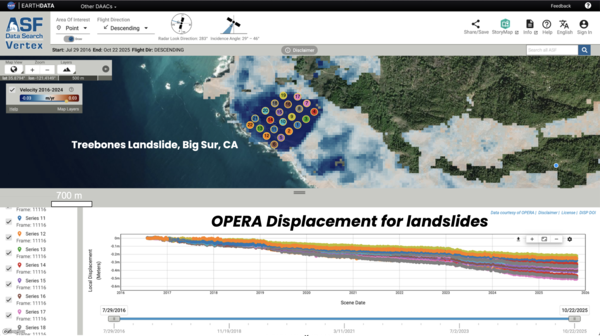
👁 Landslide Detection, Monitoring, and Research Using OPERA Data
map and chart
map and chart
Landslide Detection, Monitoring, and Research Using OPERA Data
👁 Multi-site evaluation of a postfire debris-flow runout forecast method
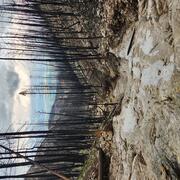
Home damaged by post fire debris flow
Home damaged by post fire debris flow
Multi-site evaluation of a postfire debris-flow runout forecast method
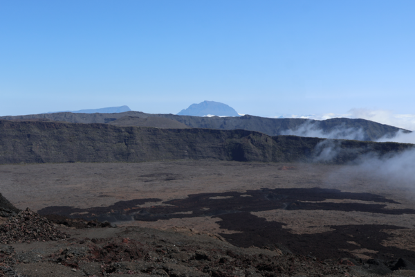
Piton de la Fournaise Collapse Scarps
Piton de la Fournaise Collapse Scarps
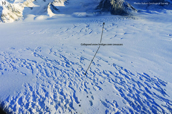
12-12-25 Hubbard Glacier Collapsed Snow Bridges
12-12-25 Hubbard Glacier Collapsed Snow Bridges
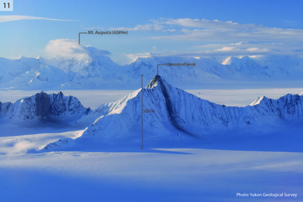
12-12-25 Mt. Vancouver and Mt. Logan Arete Landslides
12-12-25 Mt. Vancouver and Mt. Logan Arete Landslides
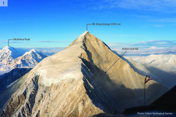
12-12-25 Mt. King George East Face Landslide
12-12-25 Mt. King George East Face Landslide
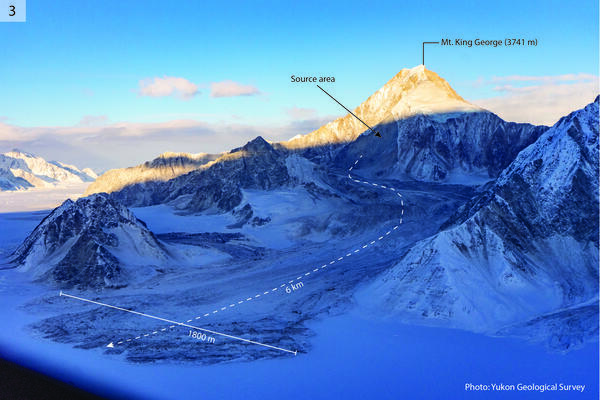
12-12-25 Mt. King George Landslide with Large Runout
12-12-25 Mt. King George Landslide with Large Runout
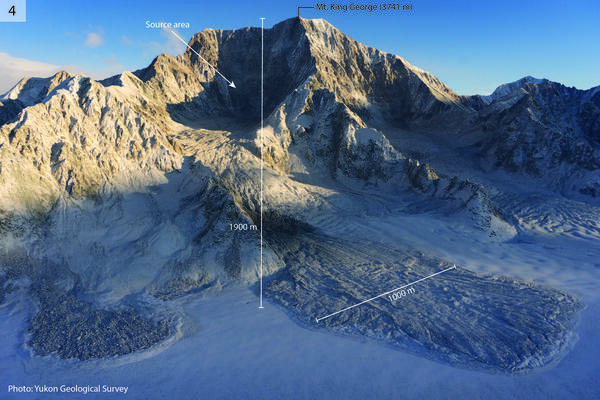
12-12-25 Mt. King George West Face Landslides
12-12-25 Mt. King George West Face Landslides
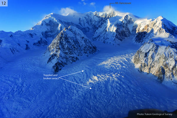
12-12-25 Mt. Vancouver Toppled Seracs
12-12-25 Mt. Vancouver Toppled Seracs