 |
VOOZH | about |
|
VOOZH | about |
Mobile/Pensacola
Weather Forecast Office
👁 National Weather Service, Mobile-Pensacola
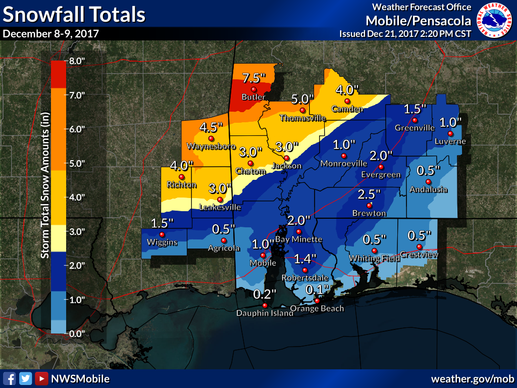
December 8-9, 2017
Summary of all Local Storm Reports (LSRs) of snow across the area on December 8th and 9th, as well as all the LSRs across the region (western portion/eastern portion) for this event.
Public Information Statement...UPDATED
National Weather Service Mobile AL
355 PM CST Thu Dec 14 2017

...Updated Snowfall Totals From December 8, 2017 Event...

The following is a list of preliminary snowfall reports from around
the southeast Mississippi, southwest Alabama, and northwest Florida
received from various sources including NWS COOP reports, CoCoRaHS,
emergency management, spotters, social media, and the public. Not all
data listed are considered official.

Location				 Amount (inches)	 Data Source

SOUTHEAST MISSISSIPPI

...George County...
Lucedale 1.5-2.0 EMA
Agricola 0.5 Public

...Greene County...
Sand Hill 6.0 EMA
Leakesville 2.0-3.0 EMA

...Perry County...
Richton 3.0-4.0 EMA
Beaumont 2.0 EMA
New Augusta 2.0 EMA

...Stone County...
Wiggins 1.0-1.5 EMA

...Wayne County...
Northern Wayne County 6.0 EMA
Southwestern Wayne County 5.0 EMA
Waynesboro 4.0-4.5 EMA
Buckatunna 4.0 COOP


SOUTHWEST ALABAMA

...Baldwin County...
Bay Minette 2.0 Public
Loxley 2.0 Spotter
Robertsdale 1.4 COOP
Phillipsville 1.25 Public
Loxley 0.4 SSW 1.0 CoCoRaHS
Rosinton 1.0 Social Media
Malbis 0.5-1.0 NWS Employee
Daphne 4.9 SE 0.5 CoCoRaHS
Fairhope 2.3N 0.4 CoCoRaHS
Fairhope 2NE 1.0 COOP
Foley 0.5 ESE Trace CoCoRaHS

...Butler County...
Greenville 1.25-1.5 EMA

...Choctaw County...
Butler 7.5-8 EMA
Needham 7.5 Social Media
Toxey 7.5 Social Media
Wimbly 7.0 Social Media
Gilbertown 6.5 Social Media
Lusk 6.5 Social Media
Melvin 6.0 Social Media
Yantley 6.0 Social Media
Cullomburg 2.5 Media

...Clarke County...
West Bend 4.0 EMA
Jackson 3.0 COOP
Thomasville 5.0 EMA (updated)
Grove Hill 2.0-3.0 EMA

...Conecuh County...
Evergreen 2.0 COOP
I-65 and AL Hwy 41 1.5 Social Media

...Covington County...
Covington County Trace-0.5 EMA

...Crenshaw County...
Luverne 1.0 EMA

...Escambia County...
Brewton 2.5 Media
Appleton 1.5 Spotter
Atmore 1.0 COOP

...Mobile County...
Mobile Regional Airport 1.0 NWS
Tillman's Corner 4.3 WNW 1.0 CoCoRaHS
Wilmer 7.9 SE 0.3 CoCoRaHS
Dauphin Island 2.2 E 0.2 CoCoRaHS
Fowl River entrance 0.5 NWS

...Monroe County...
Excel 1.0 Spotter
Monroeville 1.0 Spotter

...Washington County...
Millry 2.5-3.0 EMA
Leroy 1.5-2.0 EMA
Sunflower 0.75-1.0 EMA

...Wilcox County...
Camden 4.0 Social Media
Pine Hill 3.6 WSW 3.3 CoCoRaHS
Pine Apple 3.0 COOP


NORTHWEST FLORIDA

...Escambia County...
Century 2.0 EMA
Ferry Pass 0.25 Social Media
Gonzalez 2.5 NNW 0.1 CoCoRaHS
Pensacola 1.9 NE Trace CoCoRaHS

...Santa Rosa County...
Near Whiting Field 0.25-0.5 EMA

...Okaloosa County...
Crestview 0.5 EMA
Page created by Jason Beaman (Warning Coordination Meteorologist) and Morgan Barry (Forecaster).