
Bicas | |
|---|---|
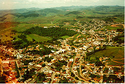
| 👁 View of Bicas View of Bicas | |
| 👁 Location in Brazil Location in Brazil | |
| Coordinates: 21°43′30″S 43°03′32″W / 21.72500°S 43.05889°W / -21.72500; -43.05889 | |
| Country | 👁 Image Brazil |
| Region | Southeast |
| State | Minas Gerais |
| Mesoregion | Zona da Mata |
| Microregion | Juiz de Fora |
| Founded | September 7th, 1923 |
| Government | |
| • Mayor | Geraldo Magela Longo dos Santos |
| Area | |
• Total | 139,538 km2 (53,876 sq mi) |
| Elevation | 600.0 m (1,968.5 ft) |
| Population (2020 [2]) | |
• Total | 14,554 |
| Time zone | UTC−3 (BRT) |
| HDI (2000) | 0.799 |
| Website | Bicas, Minas Gerais |
Bicas is a Brazilian municipality in the state of Minas Gerais. As of 2020[update] its population is estimated to be 14,554 inhabitants.
History
[edit]Originally, a stopping point for salesmen in the 18th century, Bicas gained its independence from the city of Guarará in 1923. It served as a destination for Italian immigrants and other nationalities.
Until the 1970s, Bicas had a full-working train station and an active RFFSA (the extinct state railroad company) branch for repairing wagons. The entire structure was dismantled and today the train station exists only as a historic site. Currently, Bicas has an economy based on commerce, agriculture and farming.
Annual Farming Expositions, with bull-riding and rodeos, cattle commerce and local products - typically in the last week of July of every year - are a tradition of several cities in Zona da Mata, and the Farming Exposition of Bicas is one of the most famous, attracting thousands of tourists from several parts of the country.
Notable people
[edit]- Danilo Football player
Aerial photos
[edit]-
Satellite photo, 1993-06-24, real colour.
-
Satellite photo, 1993-06-24, real colour, sharpened to show smaller roads and details.
-
👁 Satellite photo, 1993-06-24, highlighting dense wood covering (bright red), grass (brown) and buildings (green)Satellite photo, 1993-06-24, highlighting dense wood covering (bright red), grass (brown) and buildings (green)
-
👁 Satellite photo, 1993-06-24, strongly contrasting dense wood covering (green), grass (brown), buildings (purple) and naked land areas (orange)Satellite photo, 1993-06-24, strongly contrasting dense wood covering (green), grass (brown), buildings (purple) and naked land areas (orange)
-
Satellite photo, 1993-06-24, showing buildings and roads (light grey)
See also
[edit]References
[edit]- ^ "Área territorial oficial" [Official Territorial Area] (in Portuguese). Brazilian Institute of Geography and Statistics (IBGE). 2002-10-10. Retrieved 2010-12-05.
- ^ IBGE 2020
- Pages using gadget WikiMiniAtlas
- CS1 Portuguese-language sources (pt)
- Articles with short description
- Short description is different from Wikidata
- Coordinates on Wikidata
- Articles containing potentially dated statements from 2020
- All articles containing potentially dated statements
- Commons category link is on Wikidata