
From Wikipedia, the free encyclopedia
Municipality in Southeast, Brazil
Camanducaia | |
|---|---|
| Municipality of Camanducaia | |
| Nicknames: Campos Queimados | |
| 👁 Location in Minas Gerais Location in Minas Gerais | |
| Coordinates: 14°25′03″S 44°22′13″W / 14.41750°S 44.37028°W / -14.41750; -44.37028 | |
| Country | 👁 Image Brazil |
| Region | Southeast |
| State | 👁 Image Minas Gerais |
| Founded | July 20, 1868 |
| Government | |
| • Mayor | Edmar Cassalho Moreira Dias (PMDB) |
| Area | |
• Total | 527.572 km2 (203.697 sq mi) |
| Elevation | 1,015 m (3,330 ft) |
| Population (2020 [1]) | |
• Total | 21,801 |
| • Density | 40/km2 (100/sq mi) |
| Time zone | UTC-3 (UTC-3) |
| • Summer (DST) | UTC-2 (UTC-2) |
| HDI (2010) | 0.689 – medium[2] |
_-_Panorama.jpg)
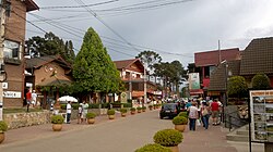
Camanducaia is the southernmost municipality in Minas Gerais, Brazil. The population was 21,801 in 2020.
The municipality contains part of the 180,373-hectare (445,710-acre) Fernão Dias Environmental Protection Area, created in 1997.[3]
See also
[edit]References
[edit]- ^ IBGE 2020
- ^ "Archived copy" (PDF). United Nations Development Programme (UNDP). Archived from the original (PDF) on July 8, 2014. Retrieved August 1, 2013.
{{cite web}}: CS1 maint: archived copy as title (link) - ^ APA Fernão Dias (in Portuguese), ISA: Instituto Socioambiental, retrieved 2016-10-02
{{citation}}: CS1 maint: publisher location (link)
| 👁 Stub icon | This geographical article relating to Intermediate Geographic Region of Pouso Alegre is a stub. You can help Wikipedia by adding missing information. |