Latitude & Longitude (WGS84):
35° 5' 58'' North , 114° 26' 51'' West
Latitude & Longitude (decimal):
Nearest Clubs:
Local clubs are the best way to get access to collecting localities
Long-form identifier:
mindat:1:2:39545:1
A former Au-Ag-fluorspar occurrence/mine located in the NW¼SW¼SE¼ sec. 19, T20N, R20W, G&SRM, 6 miles NW of Oatman and 2 miles North of Silver Creek in the old San Francisco District, on private (patented) lanbd within a Bureau of Land Management administered area. Discovered in 1864. Owned by Lloyd Moss, Arizona (1974). This was the leading mine of the district. The USGS MRDS database stated accuracy for this locality is 500 meters.
MOSS MINE.
Location and history. The Moss mine is about 4 miles northwest of Gold Road and 2¼ miles west of the Moss Back mine, to the north of Silver Creek. It lies in a well-mineralized area on the southeast slope of a group of outlying hills, the Moss Hills, which trend west to a point about 1½ miles beyond the mine. This mine, the original discovery in the country here discussed, was located in 1863 or 1864 by John Moss, who found much free visible gold exposed in the croppings about where the shaft is now sunk. On this spot, from a hole about 10 feet in diameter and depth, he took out $240,000 in gold, all of which he immediately spent in development work, much of which was ill advised. Moss died later in poverty.
The rich ore was contained in reddish-brown hematite or iron stained quartz croppings, which Silliman aptly describes as having the appearance of sulphide-bearing quartz that had been roasted. Much of it was covered with flakes, incrustations, and beads of gold from the size of shot or pea to that of a hazelnut. Two tons of ore taken from the outcrop of the vein is said to have netted $114,000 in San Francisco, and the exhibition of this rich ore led many men to brave the dangers of the desert and the Indians to reach the district.
The mine was worked principally in pioneer times, at first by the Moss Brothers. After the rich find a 10-stamp mill was built on Silver Creek just below the Holmes camp, where some of the ore may still be seen. Dahlgreen Black is said to have enlisted eastern capital and operated the mine after the Moss Brothers. The property, including several patented claims, is now owned by the Gold Giant Mining and Milling Company, with headquarters at Los Angeles. Some development work was done on the property in 1906. The total production is $500,000.
Developments. The developments consist principally of a 230-foot double- compartment shaft and about 600 feet of tunnels and crosscuts. The shaft starts on the hanging-wall side of the vein and now contains some water. Much of the horizontal underground work is 8 by 10 feet or more in cross section and was done in the pioneer black-powder days at great cost.
The tunnel starts in a gulch about 100 feet south and 60 feet below the collar of the shaft, whence it extends diagonally to the northeast for a distance of about 250 feet, following a stringer in part nearly to the vein. It then parallels the vein westward as far as the shaft, with which it connects by a crosscut. Other crosscuts open the vein at intervals and extend into the foot wall on the north. Several shorter crosscuts also extend to the south on good-looking spur veins or stringers, but in no case more than about 30 feet, which seems to indicate that the values were too low to pay.
The principal equipments are a good gasoline hoist and a small mill at Hardyville, near the mouth of Silver Creek, on Colorado River, 7 miles distant.
Geology. The country rock is a quartz syenite porphyry phase of the granite porphyry and micropegmatite described on page 30, butcontains more hornblende and biotite. It forms a considerable part of the Moss Hills and underlies the younger volcanic rocks in the vicinity. Northward it extends for a distance of half a mile or more to a point about one-fourth of a mile beyond the Moss mine saddle and southward nearly to Silver Creek and the Holmes camp, probably connecting locally with the same rock in the Hardy Mountains. It weathers reddish brown.
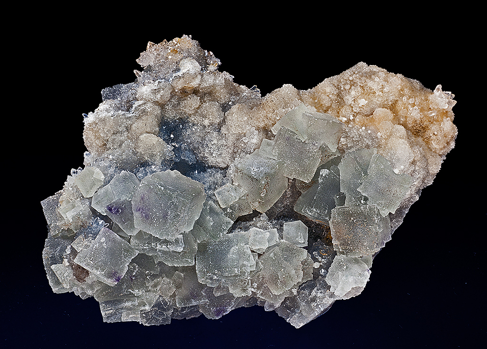
Veins and ore. The Moss vein as seen underground has a width of about 22 feet and a known extent of more than half a mile and a reported extent of about 4 miles, being held by some to connect with the Moss Back vein. It dips steeply to the south and is associated with considerable fault breccia on its foot-wall side. Both sides of the vein are frozen to the walls, and in consequence of this the walls are torn and ragged where the vein has been mined. The-croppings, which in large part are prominent and of the Gold Road type, consist principally of a surficially iron-stained mixture of quartz and crystalline calcite and probably adularia and silicified rock, which-in part is porous or honeycombed and is cut by a cross sheeting or slickensiding.
In the underground and less-oxidized vein the quartz and calcite are present in about equal amount and the quartz seems to have replaced calcite, both minerals being usually fine grained and very intimately intermixed or intergrown. The quartz is mainly of a greenish hue, like that of the Gold Road vein, but a considerable portion is also pale rose-red, from which the vein has commonly come to be known as the rose-quartz vein.
Under the microscope a section of the ore shows coarse granular quartz,with coarse calcite grains, also acicular calcite in triangular pattern and intervening finer-grained quartz; the quartz appears divided in sectors through the distribution of radial inclusions, probably mostly fluid. No adularia was seen in the section, but it is probably present in the ore.
East of the mine, at the wagon-road gap, where a good surface opening has lately been made, the vein has narrowed to a few feet in width, and in the most easterly crosscut on the level of the tunnel inthe mine, about 100 feet east of the shaft, it is split into several parts or stringers by horses and inclusions of the country rock.
Nearly the whole production seems to have been obtained from very rich pockets or concentrates in the croppings and highly oxidized ore near the surface, for deeper work shows the deposit to consist principally of a large body of low-grade ore, much of it averaging about $4 in gold to the ton. Several tons of the ore are reported to have averaged $6,800; two tons $42,500 each in San Francisco; and a lot of about 100 tons, which was treated at the small mill at Hardyville, about $42 a ton.
Lying near the Moss vein on either side are one or more small veins or ledges, on which assessment work is kept up. The principal one on the north is about parallel with and 500 feet distant from the Moss vein, and contains much fluorspar.
Mineralization is an immense gold ledge (Mineral occurrence model information: Model code: 150; USGS model code: 25c; Deposit model name: Epithermal vein, Comstock; Mark3 model number: 16), hosted in the Moss Quartz Monzonite-porphyry. nearly 40 feet wide. The ore body strikes N80W and dips 70S at a thickness of 67 meters, width of 30 meters and a length of 1,609 meters. Ore body No. 1 is a fissure vein. Ore body No. 2 is a shear zone. The primary mode of origin was hydrothermal activity. The vein strikes N78W and dips 70S. The lode is from 20 to more than 100 feet wide at the West end. It is traceable for more than 1 mile on the surface. The vein filling consists of fine-grained white quartz and calcite with stringers of colorless to pale-green fluorite, The largest ore shoot consisted of free gold in iron-stained quartz but only to 65 feet deep. Other, smaller ore bodies were founbd from near the surface to depths of 220 feet at various places along the vein. Local alteration includes oxidation. Associated rocks include Pliocene trachyte. Local rocks include Middle Miocene to Oligocene granitic rocks.
Regional geologic structures include a NNW- To WNW-trending vein and fault system in Tertiary volcanic rocks.
Workings include underground openings with a length of 502.92 meters and an overall depth of 70.1 meters, and comprised of shafts at 230 feet and 98 feet deep, respectively (1881), plus 1,700 feet of levels, drifts, etc.
Production statistics: $500,000 prior to 1909
Analytical data results: Vein at 220 foot level is 90 feet wide and carries 0.15 to 0.2 ounce Au/ton.
Reserves and resources data: In-situ (estimate year = 1986): Total resources 113,000 metric tons of ore with Au at 7.604 grams/metric ton.
Select Mineral List Type
Standard
Detailed Gallery
Strunz
Chemical Elements
Commodity List
This is a list of exploitable or exploited mineral commodities recorded at this locality.Mineral List
11 valid minerals.
Rock Types Recorded
Note: data is currently VERY limited. Please bear with us while we work towards adding this information!
Select Rock List Type
Alphabetical List Tree Diagram
Entries shown in red are rocks recorded for this region.
Gallery:
List of minerals arranged by Strunz 10th Edition classification
List of minerals for each chemical element
Other Databases
Other Regions, Features and Areas containing this locality
This page contains all mineral locality references listed on mindat.org. This does not claim to be a complete list. If you know of more minerals from this site, please
register so you can add to our database. This locality information is for reference purposes only. You should never attempt to
visit any sites listed in mindat.org without first ensuring that you have the permission of the land and/or mineral rights holders
for access and that you are aware of all safety precautions necessary.
References
Lausen, Carl (1931), Geology and Ore Deposits of the Oatman and Katherine Districts, Arizona Bureau of Mines Bulletin 131: 113-115, 9, 12, 44-45, 52, 60, 74, 84-85. 