Brough Castle is a ruined castle in the village of Brough, Cumbria, England. The castle was built by William Rufus around 1092 within the old Roman fort of Verterae to protect a key route through the Pennine Mountains. The initial motte and bailey castle was attacked and destroyed by the Scots in 1174 during the Great Revolt against Henry II. Rebuilt after the war, a square keep was constructed and the rest of the castle converted to stone.
The Clifford family took possession of Brough after the Second Barons' War in the 1260s; they built Clifford's Tower and undertook a sequence of renovations to the castle, creating a fortification in a typical northern English style. In 1521, however, Henry Clifford held a Christmas feast at the castle, after which a major fire broke out, destroying the property. The castle remained abandoned until Lady Anne Clifford restored the property between 1659 and 1661, using it as one of her northern country homes. In 1666 another fire broke out, once again rendering the castle uninhabitable. Brough Castle went into sharp decline and was stripped first of its fittings and then its stonework. The castle's masonry began to collapse around 1800. (Full article...)
Image 4Dove Cottage (Town End, Grasmere) – home of William and Dorothy Wordsworth, 1799–1808; home of Thomas De Quincey, 1809–1820 (from History of Cumbria)
Image 13St Mary's Church, Abbeytown : all that is left of Holmcultram Abbey, founded by David I, King of Scots, and his son, Earl Henry, in 1150 (from History of Cumbria)
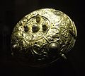
Image 23The Ormside bowl, probably late 8th century and made in Northumbria; possibly looted from York by a Viking warrior and buried with him at Great Ormside (from History of Cumbria)
Image 24The Staffordshire Moorlands Pan – an enamelled cooking and serving vessel, engraved with the names of four Hadrian's Wall forts sited in Cumbria (2nd century AD). See also the article on the Rudge Cup and Amiens skillet. (from History of Cumbria)
Image 30The Stanegate line is marked in red, to the south of the later Hadrian's Wall. (n.b. Brocavum is Brougham, not Kirkby Thore as given in the map) (from History of Cumbria)
Image 34Wray Castle – built by a Liverpool doctor who had married a rich wife. Constructed in 1840 at the head of Windermere. Associated with two key players of the National Trust : Canon Rawnsley and Beatrix Potter (from History of Cumbria)
Image 37Carlisle Castle – begun by William Rufus in 1092; rebuilt in stone under Henry I, 1122–35, and David I of Scotland, 1136–1153 (from History of Cumbria)
Image 40St Laurence's Church, Morland : with "the only tower of Anglo-Saxon character in the NW counties", according to Pevsner. Tower possibly built by order of Siward, Earl of Northumbria, sometime between 1042 and 1055; nave possibly later (1120) (from History of Cumbria)
Image 43Loki stone, Kirkby Stephen parish church, part of a 10th-century Viking-age cross-shaft. But does it show Loki or Satan? (from History of Cumbria)
Image 45Swarthy Hill, near Crosscanonby on the Solway coast – possible site of Iron Age hillfort, later the site of mile-fortlet 21 in Roman times (from History of Cumbria)
Image 48Brantwood, overlooking Coniston Water, viewed from the steam yacht 'Gondola' – note the angled, corner windows designed to take in the views (from History of Cumbria)
Image 49This map of cities and towns of Northern England shows the relative lack of urbanisation in Cumbria (shown here as the historic counties of Cumberland and Westmorland) compared to the rest of the region (from Cumbria)
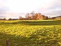
Image 50The Eden Valley between Appleby and Penrith, an area referred to affectionately as the heartland of Rheged in the praise poems of Taliesin (from History of Cumbria)
Image 54'Giants Grave', St. Andrew's churchyard, Penrith, an unusual arrangement of two Viking-age cross-shafts with four hogbacks (in the foreground). In addition, there is a smaller, Viking-age, wheel-headed cross just visible in the background (from History of Cumbria)
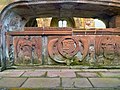
Image 59So-called "Saint's tomb" (left), and "Warrior's tomb" (right), two hogbacks in St. Mary's church, Gosforth. Typically high and narrow Cumbrian style, in the shape of a building with a roof, eaves and walls. The Saint's tomb has a crucifixion on the end, the Warrior's tomb has a procession of armed men (from History of Cumbria)
Image 65Approximate extent of Domesday coverage : the district of Hougun, if indeed it was a district, may have covered the three peninsulas at the left of the pink area (from History of Cumbria)
Image 69Claife Station on the western shore of Windermere – built in the 1790s with tinted windows angled to take in all the aesthetically pleasing views (from History of Cumbria)
Image 83The Gosforth Cross, 10th-century Viking-age sculpture. (A replica of 1887, with clearer depictions of the decoration, may be found in the churchyard at Aspatria, along with a replica of another cross, the original of which is at Dearham) (from History of Cumbria)
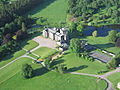
Image 84Greystoke Castle. Held by the Greystoke family, then by the Dacres and inherited by the Howard family during Elizabeth I's reign. Photo:Simon Ledingham (from History of Cumbria)
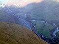
The Dales Way is an 78.5-mile (126.3 km) long-distance footpath in Northern England, from (south-east to north-west) Ilkley, West Yorkshire, to Bowness-on-Windermere, Cumbria. This walk was initially devised by the West Riding Ramblers' Association with the 'leading lights' being Colin Speakman and Tom Wilcock (Footpath Secretary). The route was announced to the public in 1968 and the first recorded crossing was by a group of Bradford Grammar School Venture Scouts in 1969.

.jpg)
.svg)
.jpg)
.jpg)