
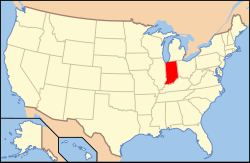
Map of the United States
with Indiana highlighted
Indigenous resistance to American settlement was broken with their defeat in Battle of Tippecanoe in 1811, and the collapse of Tecumseh's confederacy in 1813. The new settlers were primarily Americans of British ancestry from the eastern seaboard and the Upland South, and Germans. After the Civil War, in which the state fought for the Union, natural gas attracted heavy industry and new European immigrants to its northern counties. In the first half of the 20th century, northern and central sections experienced a boom in goods manufacture and automobile production. Southern Indiana remained largely rural. After the rise and fall of the Klan in the 1920s, the state swung politically from the Republican to Democratic Party in the New Deal 1930s. Today, with a decades-long record of returning Republican majorities, Indiana is counted a "red state".
Indiana has a diverse economy with a gross state product in 2023 of 404.3 billion. Indianapolis is at the center of the state's largest metropolitan area, with a population of over two million. The Fort Wayne metro area follows with a population of 645,000. (Full article...)
Selected article - show another
.svg)
The University of Notre Dame du Lac (known simply as Notre Dame; /ˌnoʊtərˈdeɪm/ ⓘ NOH-tər-DAYM; ND) is a private Catholic research university in Notre Dame, Indiana, United States. The university was founded in 1842 by members of the Congregation of Holy Cross, a Catholic religious order of priests and brothers. Its main campus covers 1,261 acres (510 ha) in a suburban setting and has landmarks such as the Golden Dome main building, Sacred Heart Basilica, the Grotto of Our Lady of Lourdes, the Word of Life mosaic mural, and Notre Dame Stadium.
Notre Dame is classified among "R1: Doctoral Universities – Very high research spending and doctorate production". The university is organized into seven schools and colleges: College of Arts and Letters, College of Science, Notre Dame Law School, School of Architecture, College of Engineering, Mendoza College of Business, and Keough School of Global Affairs. Notre Dame's graduate program includes more than 50 master, doctoral and professional degrees offered by the seven schools. (Full article...)
Selected image - show another
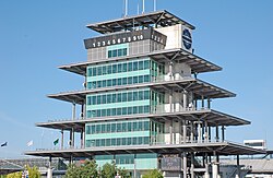
| Credit: KeithTyler |
Did you know - load new batch
- ... that an Indiana university recently argued in court that The Silver Veil and the Golden Gate, a 1914 painting, was too modern for their art collection?
- ... that the 2012 Southern Indiana tornado ripped chunks of asphalt concrete off of a road and threw the pieces 30 yards (27 m) away?
- ... that the Circle Tower, an Art Deco building in Indianapolis, features ziggurat-like upper floors?
- ... that the Indianapolis African-American community raised $100,000 in just ten days in 1911 to establish the Senate Avenue YMCA?
- ... that after becoming "convinced of the evils of slavery", James Townsend left Kentucky for Indiana?
- ... that an Indiana newspaper donated its TV station to the local high school instead of shutting it down?
Related portals
Selected geographic article - show another
Elkhart (/ˈɛlkɑːrt/ EL-kart) is a city in Elkhart County, Indiana, United States. The population was 53,923 at the 2020 census. The city is located 15 miles (24 km) east of South Bend, Indiana. It is the most populous city in the Elkhart–Goshen metropolitan area, which in turn is part of the South Bend–Elkhart–Mishawaka combined statistical area, in a region commonly known as Michiana. (Full article...)
Selected biography - show another
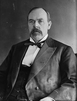
Oliver Hazard Perry Throck Morton (August 4, 1823 – November 1, 1877), commonly known as Oliver P. Morton, was a U.S. Republican Party politician from Indiana. He served as the 14th governor of Indiana during the American Civil War, and was a stalwart ally of President Abraham Lincoln.
Morton fought for equality and nationalism through the use of governmental power. His forceful pursuit of civil rights and prosecution of Copperheads and white supremacists gained him lasting enemies among the antiwar elements. Morton thwarted and neutralized the Democratic-controlled Indiana General Assembly. He exceeded his constitutional authority by calling out the militia without approval, and during the period of legislative suppression he privately financed the state government through unapproved federal and private loans. He was criticized for arresting and detaining political enemies and suspected southern sympathizers. As one of President Lincoln's "war governors", Morton made significant contributions to the war effort. (Full article...)
Selected quote
| What can I do when both parties insist on kicking?
— Benjamin Harrison, cartoon about Political football
|
General images
-
The Constitution Elm in Corydon (from History of Indiana)
-
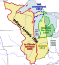
Map of the Indiana Territory (from History of Indiana)
-
👁 Image 3A restored Monon boxcar at the Linden Railroad Museum in Linden, Indiana (from History of Indiana)A restored Monon boxcar at the Linden Railroad Museum in Linden, Indiana (from History of Indiana)
-
The Circle in Indianapolis, circa 1898 (from History of Indiana)
-
👁 Image 5William Henry Harrison, the 1st Governor of Indiana Territory from 1801 to 1812, and the 9th President of the United States (from History of Indiana)William Henry Harrison, the 1st Governor of Indiana Territory from 1801 to 1812, and the 9th President of the United States (from History of Indiana)
-
👁 Image 680th Indiana Infantry Regiment and the 19th Indiana Light Artillery defending against the Confederates at the Battle of Perryville by H. Mosler (from History of Indiana)80th Indiana Infantry Regiment and the 19th Indiana Light Artillery defending against the Confederates at the Battle of Perryville by H. Mosler (from History of Indiana)
-
View of Mound A at Angel Mounds (from History of Indiana)
-
Clark's march to Vincennes, by F. C. Yohn (from History of Indiana)
-
👁 Image 9Native Americans guide French explorers through Indiana as depicted by Maurice Thompson in Stories of Indiana. (from History of Indiana)Native Americans guide French explorers through Indiana as depicted by Maurice Thompson in Stories of Indiana. (from History of Indiana)
-
👁 Image 11Driver Mel Marquette's wrecked McFarlan racing car at the 1912 Indianapolis 500 (from History of Indiana)Driver Mel Marquette's wrecked McFarlan racing car at the 1912 Indianapolis 500 (from History of Indiana)
-
👁 Image 12The fifth Indiana Statehouse in Indianapolis built in 1888 on the site of the third statehouse (from History of Indiana)The fifth Indiana Statehouse in Indianapolis built in 1888 on the site of the third statehouse (from History of Indiana)
-
Oliver Hazard Perry Morton, governor 1861 to 1867 (from History of Indiana)
-
👁 Image 14Madam C. J. Walker, Indianapolis entrepreneur and philanthropist (from History of Indiana)Madam C. J. Walker, Indianapolis entrepreneur and philanthropist (from History of Indiana)
-
A labor leader rallies striking steelworkers in Gary, Indiana (from History of Indiana)
.jpg)
Topics
- Economy: AM General - ATA Airlines - Casinos - Cummins - Delta - ITT - JayC - Lilly - Limestone - Manufacturing - NiSource - Shoe Carnival - Simon Property Group - Soybeans - Studebaker - Vectren - WellPoint
- Geography: Caves - Lakes - Rivers - State forests - Watersheds
Categories
Attractions
|
Recognized content
| 👁 Image | This is a list of recognized content, updated weekly by JL-Bot (talk · contribs) (typically on Saturdays). There is no need to edit the list yourself. If an article is missing from the list, make sure it is tagged or categorized (e.g. Category:WikiProject Indiana articles) correctly and wait for the next update. See WP:RECOG for configuration options. |
Featured articles
- 2005 United States Grand Prix
- Frank Borman
- William M. Branham
- Broad Ripple Park Carousel
- William Hayden English
- Benjamin Harrison
- John Hay
- USS Indiana (BB-1)
- Indiana-class battleship
- Janet Jackson
- Michael Jackson
- Harmon Killebrew
- Kenesaw Mountain Landis
- Abraham Lincoln
- Lochry's Defeat
- Thomas R. Marshall
- Ruth Norman
- On the Banks of the Wabash, Far Away
- Parks and Recreation season 1
- Pilot (Parks and Recreation)
- Ezra Pound
- Wiley Rutledge
- William S. Sadler
- Red Skelton
- John Gould Stephenson
- Tecumseh
- Battle of Tippecanoe
- Kurt Vonnegut
- WSNS-TV
- Warren County, Indiana
- Ryan White
- Wendell Willkie
Good articles
- 1925 Tri-State tornado
- 1963 Indiana State Fairgrounds Coliseum gas explosion
- 1984 Indiana's 8th congressional district election
- 2006 Brickyard 400
- 2008 Super Tuesday tornado outbreak
- Tornado outbreak sequence of June 3–11, 2008
- 2011 Brickyard 400
- 2011 South Bend mayoral election
- 2015 South Bend mayoral election
- 2019 South Bend mayoral election
- 2021 NCAA Division I men's basketball championship game
- 2022 College Football Playoff National Championship
- 2023 Robinson–Sullivan tornado
- Marcus Adams (Canadian football)
- Spike Albrecht
- Vic Aldridge
- Jeff Allen (defensive back, born 1958)
- William Harrison Anderson
- Paul Bako
- Sean Bennett (gridiron football)
- Max Bielfeldt
- Blackford County Courthouse
- Blackford County, Indiana
- Donald Brashear
- Brown County State Park
- Sergio Brown
- Willa Brown
- Eric Bruntlett
- Pete Buttigieg
- Canvassing (Parks and Recreation)
- Castleton Square
- Hélio Castroneves
- George Rogers Clark
- Clark State Forest
- Levi Coffin
- George R. Dale
- Frank Deig
- Chris Dittoe
- Maurice Douglass
- Duesenberg
- Kellen Dunham
- Irene Dunne
- Mary Beth Edelson
- Keith Elias
- Evan Bayh 2008 presidential campaign
- The Fault in Our Stars (film)
- Frank Fetter
- First Christian Church (Columbus, Indiana)
- Fort Wayne, Indiana
- Dario Franchitti
- Morgan Freeman
- Janie Fricke
- Crystal Gayle
- Hurley Goodall
- Governor of Indiana
- John Green
- Gus Grissom
- Rex Grossman
- Caroline Harrison
- Harrison County, Indiana
- William Henry Harrison III
- Hartford City Courthouse Square Historic District
- Hartford City Glass Company
- Gabby Hartnett
- LaTroy Hawkins
- Howard Hawks
- Kelly Hecking
- Bobby Heenan
- Mitch Henderson
- Chris Hill (basketball)
- History of slavery in Indiana
- Lauren Holiday
- Hoosier cabinet
- Sam Hornish Jr.
- Otto Frederick Hunziker
- USS Indiana (BB-58)
- Indiana General Assembly
- Indiana Glass Company
- Indiana Governor's Residence
- Indiana in the American Civil War
- Indiana State Road 930
- Indiana Statehouse
- Indiana Territory
- Indiana World War Memorial Plaza
- Indianapolis Museum of Art
- Indianapolis (Parks and Recreation)
- Indianapolis in the American Civil War
- Indianapolis streetcar strike of 1913
- Inland Steel Company
- International (Amtrak train)
- Interstate 469
- Zak Irvin
- Irwin Conference Center
- Rebbie Jackson
- Jonathan Jennings
- Tommy John
- Ezra Johnson
- James Jones (basketball, born 1980)
- Jim Jones
- Cato June
- Bob Kercher
- Ed Konopasek
- Lake James (Indiana)
- Earl Landgrebe
- Lieutenant Governor of Indiana
- Little Orphant Annie
- Kenny Lofton
- Carole Lombard
- Rami Malek
- Peyton Manning
- Mayoralty of Pete Buttigieg
- Karen McDougal
- Mitch McGary
- Mary Harrison McKee
- Bo McMillin
- Miller House (Columbus, Indiana)
- R. Ames Montgomery
- E'Twaun Moore
- Steve Morrison (American football)
- Adrian Moss (basketball, born 1988)
- New Harmony Toll Bridge
- North Christian Church
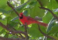
- Northern cardinal
- Old Jeffersonville Historic District
- Joel Palmer
- Charles B. Pierce
- Emma Reaney
- Tony Renna
- The Republic Newspaper Office
- Richmond, Indiana, facility fire
- James Whitcomb Riley
- Oscar Robertson
- Glenn Robinson III
- Ned Rorem
- Axl Rose
- Gunther E. Rothenberg
- Clay Rush
- Lou Rymkus
- Lou Saban
- Salesforce Marketing Cloud
- Germany Schulz
- Everett Scott
- Seal of Indiana
- David M. Shoup
- Connie Smith
- Walter Bedell Smith
- Sneath Glass Company
- South Shore Line Airport Realignment
- Brad Stevens
- John Stonebraker
- Super Bowl XLVI halftime show
- Indiana Supreme Court
- Caleb Swanigan
- Andrew Tate
- William S. Taylor (Kentucky politician)
- Thomas Trueblood
- U.S. Route 30 in Indiana
- University Park Mall
- Harold Urey
- Jacques Villeneuve
- WBAA
- WCAE
- Steve Wariner
- WDRB
- WFYI (TV)
- WGBO-DT
- Ted Wheeler (Stranger Things)
- Dan Wheldon
- William P. Dole
- Leona Woods
- WSJV
- WXIN
- WXIX-TV
Featured pictures
-
Baseball glass workers2
-
Carl Van Vechten - Shirley Graham Du Bois
-
GRESHAM, Walter Q-Treasury (BEP engraved portrait)
-
HARRISON, Benjamin-President (BEP engraved portrait)
-
HARRISON, William H-President (BEP engraved portrait)
-
Ida Husted Harper photograph by Aime Dupont
-
Indiana state coat of arms (illustrated, 1876)
-
James D Watson
-
Kenje Ogata 1943
-
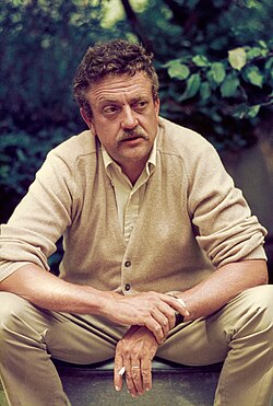
Kurt Vonnegut by Bernard Gotfryd (1965)
-
McCULLOCH, Hugh-Treasury (BEP engraved portrait)
-
Midnight at the glassworks2b
-
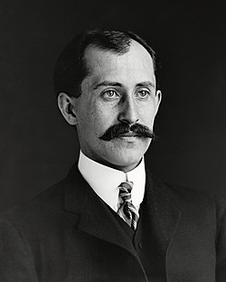
Orville Wright 1905-crop
-
Pach Brothers - Benjamin Harrison
-
US-NBN-IL-Lebanon-2057-Orig-1-400-C
-
Vernon E. Jordan working on a voter education project
-
Wilbur Wright-crop
.jpg)
.jpg)
.jpg)
.jpg)
.jpg)
.jpg)
WikiProjects
State facts
Indiana | |
|---|---|
| Country | United States |
| Admitted to the Union | December 11, 1816 (19th) |
| Capital | Indianapolis |
| Largest city | Indianapolis |
| Largest metro and urban areas | Indianapolis-Carmel MSA |
| Government | |
| • Governor | Eric Holcomb (R) (2017) |
| • Lieutenant Governor | Suzanne Crouch (R) (2017) |
| Legislature | Indiana General Assembly |
| • Upper house | Senate |
| • Lower house | House of Representatives |
| U.S. senators | Todd Young (R) Mike Braun (R) |
| Population | |
• Total | 6,080,485 |
| • Density | 169.5/sq mi (65.46/km2) |
| Language | |
| • Official language | English |
| Latitude | 37° 46′ N to 41° 46′ N |
| Longitude | 84° 47′ W to 88° 6′ W |
.JPG)
Things you can do
|
👁 Image |
Here are some tasks awaiting attention:
|
Associated Wikimedia
The following Wikimedia Foundation sister projects provide more on this subject:
-
Commons
Free media repository -
Wikibooks
Free textbooks and manuals -
Wikidata
Free knowledge base -
Wikinews
Free-content news -
Wikiquote
Collection of quotations -
Wikisource
Free-content library -
Wikiversity
Free learning tools -
Wikivoyage
Free travel guide -
Wiktionary
Dictionary and thesaurus
40°N 86°W / 40°N 86°W / 40; -86
- ^ a b "Elevations and Distances in the United States". U.S Geological Survey. 29 April 2005. Retrieved 2006-11-06.
{{cite web}}: CS1 maint: year (link)
- Pages using the Phonos extension
- Pages using gadget WikiMiniAtlas
- Portals with triaged subpages from June 2018
- All portals with triaged subpages
- Portals with no named maintainer
- Pages including recorded pronunciations
- Random portal component with 11–15 available image subpages
- Random portal component with 16–20 available subpages
- CS1 maint: year