
Geophysics (/ˌdʒiːoʊˈfɪzɪks/) is a physical science concerned with the processes and properties of Earth and its surrounding space environment, studied using quantitative and observational methods. It focuses primarily on Earth’s shape and its gravitational, magnetic, and electromagnetic fields. It also studies internal structure, composition, and dynamics, and their surface expression in tectonics, volcanism, and rock formation. Geophysics also encompasses a broader Earth-system and planetary perspective, including the oceans, atmosphere, cryosphere, ionosphere, magnetosphere, as well as solar–terrestrial interactions and analogous processes on the Moon, other planets, and their satellites.
It is one of the oldest sciences, dating back to antiquity with the development of early seismometers and magnetic compasses, and later extending to Newtonian analyses of tides, precession, and Earth’s physical properties. Today, geophysics is pursued for fundamental scientific understanding and practical applications, including the exploration of mineral and energy resources, assessment and mitigation of natural hazards, groundwater and environmental studies, archaeological investigations, and environmental monitoring. (Full article...)
Selected general articles
-
👁 Image 1 The Chandler wobble or Chandler variation of latitude is a small deviation in the Earth's axis of rotation relative to the solid earth, which was discovered by and named after American astronomer Seth Carlo Chandler in 1891. It amounts to change of about 9 metres (30 ft) in the point at which the axis intersects the Earth's surface and has a period of 433 days. This wobble, which is an astronomical nutation, combines with another wobble with a period of six years, so that the total polar motion varies with a period of about 7 years. The Chandler wobble is an example of the kind of motion that can occur for a freely rotating object that is not a sphere; this is called a free nutation. Somewhat confusingly, the direction of the Earth's rotation axis relative to the stars also varies with different periods, and these motions—caused by the tidal forces of the Moon and Sun—are also called nutations, except for the slowest, which are precessions of the equinoxes. (Full article...)The Chandler wobble or Chandler variation of latitude is a small deviation in the Earth's axis of rotation relative to the solid earth, which was discovered by and named after American astronomer Seth Carlo Chandler in 1891. It amounts to change of about 9 metres (30 ft) in the point at which the axis intersects the Earth's surface and has a period of 433 days. This wobble, which is an astronomical nutation, combines with another wobble with a period of six years, so that the total polar motion varies with a period of about 7 years.
The Chandler wobble is an example of the kind of motion that can occur for a freely rotating object that is not a sphere; this is called a free nutation. Somewhat confusingly, the direction of the Earth's rotation axis relative to the stars also varies with different periods, and these motions—caused by the tidal forces of the Moon and Sun—are also called nutations, except for the slowest, which are precessions of the equinoxes. (Full article...) -
👁 Image 2 Figure 1: Tidal interaction between the spiral galaxy NGC 169 and a smaller companion The tidal force or tide-generating force is the difference in gravitational attraction between different points in a gravitational field. It causes different parts of bodies to be pulled unevenly, those bodies as a result being stretched towards the attraction. It is the differential force of gravity, the net between gravitational forces, the derivative of gravitational potential, the gradient of gravitational fields. Therefore tidal forces are a residual force, a secondary effect of gravity, highlighting its spatial elements, making the closer near-side more attracted than the more distant far-side. (Full article...)
👁 Image Figure 1: Tidal interaction between the spiral galaxy NGC 169 and a smaller companion
The tidal force or tide-generating force is the difference in gravitational attraction between different points in a gravitational field. It causes different parts of bodies to be pulled unevenly, those bodies as a result being stretched towards the attraction.
It is the differential force of gravity, the net between gravitational forces, the derivative of gravitational potential, the gradient of gravitational fields. Therefore tidal forces are a residual force, a secondary effect of gravity, highlighting its spatial elements, making the closer near-side more attracted than the more distant far-side. (Full article...) -
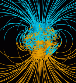
👁 Image 3 Computer simulation of Earth's field in a period of normal polarity between reversals. The lines represent magnetic field lines, blue when the field points towards the center and yellow when away. The dense clusters of lines are within Earth's core. Earth's magnetic field, also known as the geomagnetic field, is the magnetic field that extends from Earth's interior out into space, where it interacts with the solar wind, a stream of charged particles emanating from the Sun. The magnetic field is generated by electric currents due to the motion of convection currents of a mixture of molten iron and nickel in Earth's outer core: these convection currents are caused by heat escaping from the core, a natural process called a geodynamo. The magnitude of Earth's magnetic field at its surface ranges from 25 to 65 μT (0.25 to 0.65 G). As an approximation, it is represented by a field of a magnetic dipole currently tilted at an angle of about 11° with respect to Earth's rotational axis, as if there were an enormous bar magnet placed at that angle through the center of Earth. The North geomagnetic pole (Ellesmere Island, Nunavut, Canada) actually represents the South pole of Earth's magnetic field, and conversely the South geomagnetic pole corresponds to the north pole of Earth's magnetic field (because opposite magnetic poles attract and the north end of a magnet, like a compass needle, points toward Earth's South magnetic field.) (Full article...)
👁 Image Computer simulation of Earth's field in a period of normal polarity between reversals. The lines represent magnetic field lines, blue when the field points towards the center and yellow when away. The dense clusters of lines are within Earth's core.
Earth's magnetic field, also known as the geomagnetic field, is the magnetic field that extends from Earth's interior out into space, where it interacts with the solar wind, a stream of charged particles emanating from the Sun. The magnetic field is generated by electric currents due to the motion of convection currents of a mixture of molten iron and nickel in Earth's outer core: these convection currents are caused by heat escaping from the core, a natural process called a geodynamo.
The magnitude of Earth's magnetic field at its surface ranges from 25 to 65 μT (0.25 to 0.65 G). As an approximation, it is represented by a field of a magnetic dipole currently tilted at an angle of about 11° with respect to Earth's rotational axis, as if there were an enormous bar magnet placed at that angle through the center of Earth. The North geomagnetic pole (Ellesmere Island, Nunavut, Canada) actually represents the South pole of Earth's magnetic field, and conversely the South geomagnetic pole corresponds to the north pole of Earth's magnetic field (because opposite magnetic poles attract and the north end of a magnet, like a compass needle, points toward Earth's South magnetic field.) (Full article...) -
👁 Image 4 Radiometric dating, radioactive dating or radioisotope dating is a technique which is used to date materials such as rocks or carbon, in which trace radioactive impurities were selectively incorporated when they were formed. The method compares the abundance of a naturally occurring radioactive isotope within the material to the abundance of its decay products, which form at a known constant rate of decay. Radiometric dating of minerals and rocks was pioneered by Ernest Rutherford (1906) and Bertram Boltwood (1907). Radiometric dating is now the principal source of information about the absolute age of rocks and other geological features, including the age of fossilized life forms or the age of Earth itself, and can also be used to date a wide range of natural and man-made materials. Together with stratigraphic principles, radiometric dating methods are used in geochronology to establish the geologic time scale. Among the best-known techniques are radiocarbon dating, potassium–argon dating and uranium–lead dating. By allowing the establishment of geological timescales, it provides a significant source of information about the ages of fossils and the deduced rates of evolutionary change. Radiometric dating is also used to date archaeological materials, including ancient artifacts. (Full article...)Radiometric dating, radioactive dating or radioisotope dating is a technique which is used to date materials such as rocks or carbon, in which trace radioactive impurities were selectively incorporated when they were formed. The method compares the abundance of a naturally occurring radioactive isotope within the material to the abundance of its decay products, which form at a known constant rate of decay. Radiometric dating of minerals and rocks was pioneered by Ernest Rutherford (1906) and Bertram Boltwood (1907). Radiometric dating is now the principal source of information about the absolute age of rocks and other geological features, including the age of fossilized life forms or the age of Earth itself, and can also be used to date a wide range of natural and man-made materials.
Together with stratigraphic principles, radiometric dating methods are used in geochronology to establish the geologic time scale. Among the best-known techniques are radiocarbon dating, potassium–argon dating and uranium–lead dating. By allowing the establishment of geological timescales, it provides a significant source of information about the ages of fossils and the deduced rates of evolutionary change. Radiometric dating is also used to date archaeological materials, including ancient artifacts. (Full article...) -
👁 Image 5 A series of small volcanic earthquakes measuring less than 4.0 on the Richter magnitude scale took place in the sparsely populated Nazko area of the Central Interior of British Columbia, Canada, from October 9, 2007, to June 12, 2008. They occurred just west of Nazko Cone, a small tree-covered cinder cone that last erupted about 7,200 years ago. No damage or casualties resulted from the Nazko earthquakes, which were too small to be felt by people, but local seismographs recorded them. The earthquake swarm occurred at the eastern end of a known volcanic zone called the Anahim Volcanic Belt. This is an east–west trending line of volcanic formations extending from the Central Coast to the Central Interior of British Columbia. (Full article...)
👁 Image
A series of small volcanic earthquakes measuring less than 4.0 on the Richter magnitude scale took place in the sparsely populated Nazko area of the Central Interior of British Columbia, Canada, from October 9, 2007, to June 12, 2008. They occurred just west of Nazko Cone, a small tree-covered cinder cone that last erupted about 7,200 years ago.
No damage or casualties resulted from the Nazko earthquakes, which were too small to be felt by people, but local seismographs recorded them. The earthquake swarm occurred at the eastern end of a known volcanic zone called the Anahim Volcanic Belt. This is an east–west trending line of volcanic formations extending from the Central Coast to the Central Interior of British Columbia. (Full article...) -
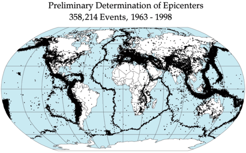
👁 Image 6 Earthquake epicenters occur mostly along tectonic plate boundaries, especially on the Pacific Ring of Fire. An earthquake, also called a quake, tremor, or temblor, is the shaking of the Earth's surface resulting from a sudden release of energy in the lithosphere that creates seismic waves. Earthquakes can range in intensity, from those so weak they cannot be felt, to those violent enough to propel objects and people into the air, damage critical infrastructure, and wreak destruction across entire cities. The seismic activity of an area is the frequency, type, and size of earthquakes experienced over a particular time. The seismicity at a particular location in the Earth is the average rate of seismic energy released per unit volume. In its most general sense, the word earthquake is used to describe any seismic event that generates seismic waves. Earthquakes can occur naturally or be induced by human activities, such as mining, fracking, and nuclear weapons testing. The initial point of rupture is called the hypocenter or focus, while the ground level directly above it is the epicenter. Earthquakes are primarily caused by geological faults, but also by volcanism, landslides, and other seismic events. (Full article...)
👁 Image Earthquake epicenters occur mostly along tectonic plate boundaries, especially on the Pacific Ring of Fire.
An earthquake, also called a quake, tremor, or temblor, is the shaking of the Earth's surface resulting from a sudden release of energy in the lithosphere that creates seismic waves. Earthquakes can range in intensity, from those so weak they cannot be felt, to those violent enough to propel objects and people into the air, damage critical infrastructure, and wreak destruction across entire cities. The seismic activity of an area is the frequency, type, and size of earthquakes experienced over a particular time. The seismicity at a particular location in the Earth is the average rate of seismic energy released per unit volume.
In its most general sense, the word earthquake is used to describe any seismic event that generates seismic waves. Earthquakes can occur naturally or be induced by human activities, such as mining, fracking, and nuclear weapons testing. The initial point of rupture is called the hypocenter or focus, while the ground level directly above it is the epicenter. Earthquakes are primarily caused by geological faults, but also by volcanism, landslides, and other seismic events. (Full article...) -
👁 Image 7 The Toronto Magnetic and Meteorological Observatory on the St. George campus of the University of Toronto The Toronto Magnetic and Meteorological Observatory, formally the Louis B. Stewart Observatory, is a historical observatory located on the St. George campus of the University of Toronto, in Toronto, Ontario, Canada. The original log building was constructed in 1840 as part of a worldwide research project run by Edward Sabine to determine the cause of fluctuations in magnetic declination. Measurements from the Toronto site demonstrated that sunspots were responsible for this effect on Earth's magnetic field. When this project concluded in 1853, the observatory was rebuilt in stone by the Canadian government and served as the country's primary meteorological station and official timekeeper for over fifty years. The observatory is considered the birthplace of Canadian astronomy. (Full article...)
👁 Image The Toronto Magnetic and Meteorological Observatory on the St. George campus of the University of Toronto
The Toronto Magnetic and Meteorological Observatory, formally the Louis B. Stewart Observatory, is a historical observatory located on the St. George campus of the University of Toronto, in Toronto, Ontario, Canada. The original log building was constructed in 1840 as part of a worldwide research project run by Edward Sabine to determine the cause of fluctuations in magnetic declination. Measurements from the Toronto site demonstrated that sunspots were responsible for this effect on Earth's magnetic field. When this project concluded in 1853, the observatory was rebuilt in stone by the Canadian government and served as the country's primary meteorological station and official timekeeper for over fifty years. The observatory is considered the birthplace of Canadian astronomy. (Full article...) -
👁 Image 8 Illustration of the dynamo mechanism that generates the Earth's magnetic field: convection currents of fluid metal in the Earth's outer core, driven by heat flow from the inner core, organized into rolls by the Coriolis force, generate circulating electric currents, which supports the magnetic field. In physics, the dynamo theory proposes a mechanism by which a celestial body such as Earth or a star generates a magnetic field. The dynamo theory describes the process through which a rotating, convecting, and electrically conducting fluid can maintain a magnetic field over astronomical time scales. A dynamo is thought to be the source of the Earth's magnetic field and the magnetic fields of Mercury and the Jovian planets. (Full article...)
👁 Image Illustration of the dynamo mechanism that generates the Earth's magnetic field: convection currents of fluid metal in the Earth's outer core, driven by heat flow from the inner core, organized into rolls by the Coriolis force, generate circulating electric currents, which supports the magnetic field.
In physics, the dynamo theory proposes a mechanism by which a celestial body such as Earth or a star generates a magnetic field. The dynamo theory describes the process through which a rotating, convecting, and electrically conducting fluid can maintain a magnetic field over astronomical time scales. A dynamo is thought to be the source of the Earth's magnetic field and the magnetic fields of Mercury and the Jovian planets. (Full article...) -
👁 Image 9 Cloud-to-ground lightning. Typically, lightning discharges 30,000 amperes, at up to 100 million volts, and emits light, radio waves, x-rays and even gamma rays. Plasma temperatures in lightning can approach 28,000 kelvins. Atmospheric electricity describes the electrical charges in the Earth's atmosphere (or that of another planet). The movement of charge between the Earth's surface, the atmosphere, and the ionosphere is known as the global atmospheric electrical circuit. Atmospheric electricity is an interdisciplinary topic with a long history, involving concepts from electrostatics, atmospheric physics, meteorology and Earth science. Thunderstorms act as a giant battery in the atmosphere, charging up the electrosphere to about 400,000 volts with respect to the surface. This sets up an electric field throughout the atmosphere, which decreases with increase in altitude. Atmospheric ions created by cosmic rays and natural radioactivity move in the electric field, so a very small current flows through the atmosphere, even away from thunderstorms. Near the surface of the Earth, the magnitude of the field is on average around 100 V/m, oriented such that it drives positive charges down. (Full article...)
👁 Image Cloud-to-ground lightning. Typically, lightning discharges 30,000 amperes, at up to 100 million volts, and emits light, radio waves, x-rays and even gamma rays. Plasma temperatures in lightning can approach 28,000 kelvins.
Atmospheric electricity describes the electrical charges in the Earth's atmosphere (or that of another planet). The movement of charge between the Earth's surface, the atmosphere, and the ionosphere is known as the global atmospheric electrical circuit. Atmospheric electricity is an interdisciplinary topic with a long history, involving concepts from electrostatics, atmospheric physics, meteorology and Earth science.
Thunderstorms act as a giant battery in the atmosphere, charging up the electrosphere to about 400,000 volts with respect to the surface. This sets up an electric field throughout the atmosphere, which decreases with increase in altitude. Atmospheric ions created by cosmic rays and natural radioactivity move in the electric field, so a very small current flows through the atmosphere, even away from thunderstorms. Near the surface of the Earth, the magnitude of the field is on average around 100 V/m, oriented such that it drives positive charges down. (Full article...) -
👁 Image 10 Precessional movement of Earth. Earth rotates (white arrows) about once a day around its rotational axis (red); this axis itself rotates slowly (white circle), completing a rotation in approximately 26,000 years In astronomy, axial precession is a gravity-induced, slow, and continuous change in the orientation of an astronomical body's rotational axis. In the absence of precession, the astronomical body's orbit would show axial parallelism. In particular, Earth's axial precession is the gradual shift in the orientation of Earth's axis of rotation. It has a cycle of approximately 26,000 years, tracing out a double cone with a half-aperture of about 23.4°, an angle known as the obliquity of the ecliptic. This is similar to the precession of a spinning top. The term "precession" typically refers only to this largest part of the motion; other changes in the alignment of Earth's axis—nutation and polar motion—are much smaller in magnitude. Earth's precession was historically called the precession of the equinoxes, because the equinoxes moved westward along the ecliptic relative to the fixed stars, opposite to the yearly motion of the Sun along the ecliptic. Historically, the discovery of the precession of the equinoxes is usually attributed in the West to the 2nd-century-BC astronomer Hipparchus. With improvements in the ability to calculate the gravitational force between planets during the first half of the nineteenth century, it was recognized that the ecliptic itself moved slightly, which was named planetary precession, as early as 1863, while the dominant component was named lunisolar precession. Their combination was named general precession, instead of precession of the equinoxes. (Full article...)
👁 Image Precessional movement of Earth. Earth rotates (white arrows) about once a day around its rotational axis (red); this axis itself rotates slowly (white circle), completing a rotation in approximately 26,000 years
In astronomy, axial precession is a gravity-induced, slow, and continuous change in the orientation of an astronomical body's rotational axis. In the absence of precession, the astronomical body's orbit would show axial parallelism. In particular, Earth's axial precession is the gradual shift in the orientation of Earth's axis of rotation. It has a cycle of approximately 26,000 years, tracing out a double cone with a half-aperture of about 23.4°, an angle known as the obliquity of the ecliptic. This is similar to the precession of a spinning top. The term "precession" typically refers only to this largest part of the motion; other changes in the alignment of Earth's axis—nutation and polar motion—are much smaller in magnitude.
Earth's precession was historically called the precession of the equinoxes, because the equinoxes moved westward along the ecliptic relative to the fixed stars, opposite to the yearly motion of the Sun along the ecliptic. Historically,
the discovery of the precession of the equinoxes is usually attributed in the West to the 2nd-century-BC astronomer Hipparchus. With improvements in the ability to calculate the gravitational force between planets during the first half of the nineteenth century, it was recognized that the ecliptic itself moved slightly, which was named planetary precession, as early as 1863, while the dominant component was named lunisolar precession. Their combination was named general precession, instead of precession of the equinoxes. (Full article...) -
👁 Image 11 A picture of Earth and the Moon from Mars. The presence of the Moon (which has about 1/81 the mass of Earth), is slowing Earth's rotation and extending the day by a little under 2 milliseconds every 100 years. Tidal acceleration is an effect of the tidal forces between an orbiting natural satellite (e.g. the Moon) and the primary planet that it orbits (e.g. Earth). The acceleration causes a gradual recession of a satellite in a prograde orbit (satellite moving to a higher orbit, away from the primary body, with a lower orbital speed and hence a longer orbital period), and a corresponding slowdown of the primary's rotation, known as tidal braking. See supersynchronous orbit. The process eventually leads to tidal locking, usually of the smaller body first, and later the larger body (e.g. theoretically with Earth-Moon system in 50 billion years). The Earth–Moon system is the best-studied case. The similar process of tidal deceleration occurs for satellites that have an orbital period that is shorter than the primary's rotational period, or that orbit in a retrograde direction. These satellites will have a higher and higher orbital velocity and a shorter and shorter orbital period, until a final collision with the primary. See subsynchronous orbit. (Full article...)
👁 Image A picture of Earth and the Moon from Mars. The presence of the Moon (which has about 1/81 the mass of Earth), is slowing Earth's rotation and extending the day by a little under 2 milliseconds every 100 years.
Tidal acceleration is an effect of the tidal forces between an orbiting natural satellite (e.g. the Moon) and the primary planet that it orbits (e.g. Earth). The acceleration causes a gradual recession of a satellite in a prograde orbit (satellite moving to a higher orbit, away from the primary body, with a lower orbital speed and hence a longer orbital period), and a corresponding slowdown of the primary's rotation, known as tidal braking. See supersynchronous orbit. The process eventually leads to tidal locking, usually of the smaller body first, and later the larger body (e.g. theoretically with Earth-Moon system in 50 billion years). The Earth–Moon system is the best-studied case.
The similar process of tidal deceleration occurs for satellites that have an orbital period that is shorter than the primary's rotational period, or that orbit in a retrograde direction. These satellites will have a higher and higher orbital velocity and a shorter and shorter orbital period, until a final collision with the primary. See subsynchronous orbit. (Full article...) -
👁 Image 12 The Hollow Moon and the closely related Spaceship Moon are pseudoscientific hypotheses that propose that Earth's Moon is either wholly hollow or otherwise contains a substantial interior space. No scientific evidence exists to support the idea; seismic observations and other data collected since spacecraft began to orbit or land on the Moon indicate that it has a solid, differentiated interior, with a thin crust, extensive mantle, and a dense core which is significantly smaller (in relative terms) than Earth's. While Hollow Moon hypotheses usually propose the hollow space as the result of natural processes, the related Spaceship Moon hypothesis holds that the Moon is an artifact created by an alien civilization; this belief usually coincides with beliefs in UFOs or ancient astronauts. This idea dates from 1970, when two Soviet authors published a short piece in the popular press speculating that the Moon might be "the creation of alien intelligence"; since then, it has occasionally been endorsed by conspiracy theorists like Jim Marrs and David Icke. (Full article...)The Hollow Moon and the closely related Spaceship Moon are pseudoscientific hypotheses that propose that Earth's Moon is either wholly hollow or otherwise contains a substantial interior space. No scientific evidence exists to support the idea; seismic observations and other data collected since spacecraft began to orbit or land on the Moon indicate that it has a solid, differentiated interior, with a thin crust, extensive mantle, and a dense core which is significantly smaller (in relative terms) than Earth's.
While Hollow Moon hypotheses usually propose the hollow space as the result of natural processes, the related Spaceship Moon hypothesis holds that the Moon is an artifact created by an alien civilization; this belief usually coincides with beliefs in UFOs or ancient astronauts. This idea dates from 1970, when two Soviet authors published a short piece in the popular press speculating that the Moon might be "the creation of alien intelligence"; since then, it has occasionally been endorsed by conspiracy theorists like Jim Marrs and David Icke. (Full article...) -
👁 Image 13 Automatic ground penetrating Radar (upGPR) near Swiss Camp (Greenland) Near-surface geophysics is the use of geophysical methods to investigate small-scale features in the shallow (tens of meters) subsurface. It is closely related to applied geophysics or exploration geophysics. Methods used include seismic refraction and reflection, gravity, magnetic, electric, and electromagnetic methods. Many of these methods were developed for oil and mineral exploration but are now used for a great variety of applications, including archaeology, environmental science, forensic science, military intelligence, geotechnical investigation, treasure hunting, and hydrogeology. In addition to the practical applications, near-surface geophysics includes the study of biogeochemical cycles. (Full article...)
👁 Image Automatic ground penetrating Radar (upGPR) near Swiss Camp (Greenland)
Near-surface geophysics is the use of geophysical methods to investigate small-scale features in the shallow (tens of meters) subsurface. It is closely related to applied geophysics or exploration geophysics. Methods used include seismic refraction and reflection, gravity, magnetic, electric, and electromagnetic methods. Many of these methods were developed for oil and mineral exploration but are now used for a great variety of applications, including archaeology, environmental science, forensic science, military intelligence, geotechnical investigation, treasure hunting, and hydrogeology. In addition to the practical applications, near-surface geophysics includes the study of biogeochemical cycles. (Full article...) -
👁 Image 14 In geodesy, the figure of the Earth is the size and shape used to model planet Earth. The kind of figure depends on application, including the precision needed for the model. A spherical Earth is a well-known historical approximation that is satisfactory for geography, astronomy and many other purposes. Several models with greater accuracy (including ellipsoid) have been developed so that coordinate systems can serve the precise needs of navigation, surveying, cadastre, land use, and various other concerns. (Full article...)In geodesy, the figure of the Earth is the size and shape used to model planet Earth. The kind of figure depends on application, including the precision needed for the model. A spherical Earth is a well-known historical approximation that is satisfactory for geography, astronomy and many other purposes. Several models with greater accuracy (including ellipsoid) have been developed so that coordinate systems can serve the precise needs of navigation, surveying, cadastre, land use, and various other concerns. (Full article...)
-
👁 Image 15 Mineral physics is the science of materials that compose the interior of planets, particularly the Earth. It overlaps with petrophysics, which focuses on whole-rock properties. It provides information that allows interpretation of surface measurements of seismic waves, gravity anomalies, geomagnetic fields and electromagnetic fields in terms of properties in the deep interior of the Earth. This information can be used to provide insights into plate tectonics, mantle convection, the geodynamo and related phenomena. Laboratory work in mineral physics require high pressure measurements. The most common tool is a diamond anvil cell, which uses diamonds to put a small sample under pressure that can approach the conditions in the Earth's interior. (Full article...)Mineral physics is the science of materials that compose the interior of planets, particularly the Earth. It overlaps with petrophysics, which focuses on whole-rock properties. It provides information that allows interpretation of surface measurements of seismic waves, gravity anomalies, geomagnetic fields and electromagnetic fields in terms of properties in the deep interior of the Earth. This information can be used to provide insights into plate tectonics, mantle convection, the geodynamo and related phenomena.
Laboratory work in mineral physics require high pressure measurements. The most common tool is a diamond anvil cell, which uses diamonds to put a small sample under pressure that can approach the conditions in the Earth's interior. (Full article...) -
👁 Image 16 A geomagnetic storm, also known as a magnetic storm, is a temporary disturbance of the Earth's magnetosphere that is driven by interactions between the magnetosphere and large-scale transient plasma and magnetic field structures that originate on or near the Sun. The structures that produce geomagnetic storms include interplanetary coronal mass ejections (CME) and corotating interaction regions (CIR). The former often originate from solar active regions, while the latter originate at the boundary between high- and low-speed streams of solar wind. The frequency of geomagnetic storms increases and decreases with the sunspot cycle. During solar maxima, geomagnetic storms occur more often, with the majority driven by CMEs. (Full article...)A geomagnetic storm, also known as a magnetic storm, is a temporary disturbance of the Earth's magnetosphere that is driven by interactions between the magnetosphere and large-scale transient plasma and magnetic field structures that originate on or near the Sun.
The structures that produce geomagnetic storms include interplanetary coronal mass ejections (CME) and corotating interaction regions (CIR). The former often originate from solar active regions, while the latter originate at the boundary between high- and low-speed streams of solar wind. The frequency of geomagnetic storms increases and decreases with the sunspot cycle. During solar maxima, geomagnetic storms occur more often, with the majority driven by CMEs. (Full article...) -
👁 Image 17 This marker indicating sea level is situated between Jerusalem and the Dead Sea. Mean sea level (MSL, often shortened to sea level) is an average surface level of one or more among Earth's coastal bodies of water from which heights such as elevation may be measured. The global MSL is a type of vertical datum – a standardised geodetic datum – that is used, for example, as a chart datum in cartography and marine navigation, or, in aviation, as the standard sea level at which atmospheric pressure is measured to calibrate altitude and, consequently, aircraft flight levels. A common and relatively straightforward mean sea-level standard is instead a long-term average of tide gauge readings at a particular reference location. The term above sea level generally refers to the height above mean sea level (AMSL). The term APSL means above present sea level, comparing sea levels in the past with the level today. (Full article...)
👁 Image This marker indicating sea level is situated between Jerusalem and the Dead Sea.
Mean sea level (MSL, often shortened to sea level) is an average surface level of one or more among Earth's coastal bodies of water from which heights such as elevation may be measured. The global MSL is a type of vertical datum – a standardised geodetic datum – that is used, for example, as a chart datum in cartography and marine navigation, or, in aviation, as the standard sea level at which atmospheric pressure is measured to calibrate altitude and, consequently, aircraft flight levels. A common and relatively straightforward mean sea-level standard is instead a long-term average of tide gauge readings at a particular reference location.
The term above sea level generally refers to the height above mean sea level (AMSL). The term APSL means above present sea level, comparing sea levels in the past with the level today. (Full article...) -
👁 Image 18 Magnetic stripes are the result of reversals of the Earth's field and seafloor spreading. New oceanic crust is magnetized as it forms and then it moves away from the ridge in both directions. The models show a ridge (a) about 5 million years ago (b) about 2 million years ago and (c) in the present. Paleomagnetism (occasionally palaeomagnetism) is the study of prehistoric Earth's magnetic fields recorded in rocks, sediment, or archeological materials. Geophysicists who specialize in paleomagnetism are called paleomagnetists. Certain magnetic minerals in rocks can record the direction and intensity of Earth's magnetic field at the time they formed. This record provides information on the past behavior of the geomagnetic field and the past location of tectonic plates. The record of geomagnetic reversals preserved in volcanic and sedimentary rock sequences (magnetostratigraphy) provides a time-scale that is used as a geochronologic tool. (Full article...)
👁 Image Magnetic stripes are the result of reversals of the Earth's field and seafloor spreading. New oceanic crust is magnetized as it forms and then it moves away from the ridge in both directions. The models show a ridge (a) about 5 million years ago (b) about 2 million years ago and (c) in the present.
Paleomagnetism (occasionally palaeomagnetism) is the study of prehistoric Earth's magnetic fields recorded in rocks, sediment, or archeological materials. Geophysicists who specialize in paleomagnetism are called paleomagnetists.
Certain magnetic minerals in rocks can record the direction and intensity of Earth's magnetic field at the time they formed. This record provides information on the past behavior of the geomagnetic field and the past location of tectonic plates. The record of geomagnetic reversals preserved in volcanic and sedimentary rock sequences (magnetostratigraphy) provides a time-scale that is used as a geochronologic tool. (Full article...) -
👁 Image 19 Simplified model of mantle convection: Whole-mantle convection Mantle convection is the very slow creep of Earth's solid silicate mantle as convection currents carry heat from the interior to the planet's surface. Mantle convection causes tectonic plates to move around the Earth's surface. The Earth's lithosphere rides atop the asthenosphere, and the two form the components of the upper mantle. The lithosphere is divided into tectonic plates that are continuously being created or consumed at plate boundaries. Accretion occurs as mantle is added to the growing edges of a plate, associated with seafloor spreading. Upwelling beneath the spreading centers is a shallow, rising component of mantle convection and in most cases not directly linked to the global mantle upwelling. The hot material added at spreading centers cools down by conduction and convection of heat as it moves away from the spreading centers. At the consumption edges of the plate, the material has thermally contracted to become dense, and it sinks under its own weight in the process of subduction usually at an oceanic trench. Subduction is the descending component of mantle convection. (Full article...)
👁 Image Simplified model of mantle convection: Whole-mantle convection
Mantle convection is the very slow creep of Earth's solid silicate mantle as convection currents carry heat from the interior to the planet's surface. Mantle convection causes tectonic plates to move around the Earth's surface.
The Earth's lithosphere rides atop the asthenosphere, and the two form the components of the upper mantle. The lithosphere is divided into tectonic plates that are continuously being created or consumed at plate boundaries. Accretion occurs as mantle is added to the growing edges of a plate, associated with seafloor spreading. Upwelling beneath the spreading centers is a shallow, rising component of mantle convection and in most cases not directly linked to the global mantle upwelling. The hot material added at spreading centers cools down by conduction and convection of heat as it moves away from the spreading centers. At the consumption edges of the plate, the material has thermally contracted to become dense, and it sinks under its own weight in the process of subduction usually at an oceanic trench. Subduction is the descending component of mantle convection. (Full article...) -
👁 Image 20 Animation of tsunami triggered by the 2004 Indian Ocean earthquake Seismology (/saɪzˈmɒlədʒi, saɪs-/; from Ancient Greek σεισμός (seismós), meaning 'earthquake', and -λογία (-logía), meaning 'study of') is the scientific study of earthquakes (or generally, quakes) and the generation and propagation of elastic waves through planetary bodies. It also includes studies of the environmental effects of earthquakes such as tsunamis; other seismic sources such as volcanoes, plate tectonics, glaciers, rivers, oceanic microseisms, and the atmosphere; and artificial processes such as explosions. Paleoseismology is a related field that uses geology to infer information regarding past earthquakes. A recording of Earth's motion as a function of time, created by a seismograph is called a seismogram. A seismologist is a scientist who works in basic or applied seismology. (Full article...)
👁 Image Animation of tsunami triggered by the 2004 Indian Ocean earthquake
Seismology (/saɪzˈmɒlədʒi,saɪs-/; from Ancient Greek σεισμός (seismós), meaning 'earthquake', and -λογία (-logía), meaning 'study of') is the scientific study of earthquakes (or generally, quakes) and the generation and propagation of elastic waves through planetary bodies. It also includes studies of the environmental effects of earthquakes such as tsunamis; other seismic sources such as volcanoes, plate tectonics, glaciers, rivers, oceanic microseisms, and the atmosphere; and artificial processes such as explosions.
Paleoseismology is a related field that uses geology to infer information regarding past earthquakes. A recording of Earth's motion as a function of time, created by a seismograph is called a seismogram. A seismologist is a scientist who works in basic or applied seismology. (Full article...) -
👁 Image 21 The Compton–Belkovich Thorium Anomaly, viewed from the Lunar Reconnaissance Orbiter in 2009 The Compton–Belkovich Thorium Anomaly is a volcanic complex on the far side of the Moon. It was found by a gamma-ray spectrometer in 1998 and is an area of concentrated thorium, a 'fertile' element. Lunar rock samples from the Apollo missions reveal that most lunar volcanism occurred around 3 to 4 billion years ago, but this feature could have formed as recently as 1 billion years ago due to the unknown history of the Moon's far side. (Full article...)
The Compton–Belkovich Thorium Anomaly is a volcanic complex on the far side of the Moon. It was found by a gamma-ray spectrometer in 1998 and is an area of concentrated thorium, a 'fertile' element. Lunar rock samples from the Apollo missions reveal that most lunar volcanism occurred around 3 to 4 billion years ago, but this feature could have formed as recently as 1 billion years ago due to the unknown history of the Moon's far side. (Full article...) -
👁 Image 22 Geodynamics is a subfield of geophysics dealing with dynamics of the Earth. It applies physics, chemistry and mathematics to the understanding of how mantle convection leads to plate tectonics and geologic phenomena such as seafloor spreading, mountain building, volcanoes, earthquakes, or faulting. It also attempts to probe the internal activity by measuring magnetic fields, gravity, and seismic waves, as well as the mineralogy of rocks and their isotopic composition. Methods of geodynamics are also applied to exploration of other planets. (Full article...)Geodynamics is a subfield of geophysics dealing with dynamics of the Earth. It applies physics, chemistry and mathematics to the understanding of how mantle convection leads to plate tectonics and geologic phenomena such as seafloor spreading, mountain building, volcanoes, earthquakes, or faulting. It also attempts to probe the internal activity by measuring magnetic fields, gravity, and seismic waves, as well as the mineralogy of rocks and their isotopic composition. Methods of geodynamics are also applied to exploration of other planets. (Full article...)
-
👁 Image 23 Temperature profile of inner Earth, schematic view (estimated). The red dashed line shows the minimum temperature for the respective mantle rock to melt. The geothermal gradient remains below the melting temperature of the rock, except in the asthenosphere. Sharp rises occur in the uppermost mantle and at the core–mantle boundary. Geothermal gradient is the rate of change in temperature with respect to increasing depth in Earth's interior. As a general rule, the crust temperature rises with depth due to the heat flow from the much hotter mantle; away from tectonic plate boundaries, temperature rises with depth at a rate of about 25–30 °C/km (72–87 °F/mi) near the surface in the continental crust. However, in some cases the temperature may drop with increasing depth, especially near the surface, a phenomenon known as inverse or negative geothermal gradient. The effects of weather and climate are shallow, only reaching a depth of roughly 10–20 m (33–66 ft).[contradictory] Strictly speaking, geo-thermal necessarily refers to Earth, but the concept may be applied to other planets. In SI units, the geothermal gradient is expressed in degree celsius per kilometre (°C/km), kelvin per kilometre (K/km), or millikelvin per metre (mK/m); these are all equivalent. (Full article...)
👁 Image Temperature profile of inner Earth, schematic view (estimated). The red dashed line shows the minimum temperature for the respective mantle rock to melt. The geothermal gradient remains below the melting temperature of the rock, except in the asthenosphere. Sharp rises occur in the uppermost mantle and at the core–mantle boundary.
Geothermal gradient is the rate of change in temperature with respect to increasing depth in Earth's interior. As a general rule, the crust temperature rises with depth due to the heat flow from the much hotter mantle; away from tectonic plate boundaries, temperature rises with depth at a rate of about 25–30 °C/km (72–87 °F/mi) near the surface in the continental crust. However, in some cases the temperature may drop with increasing depth, especially near the surface, a phenomenon known as inverse or negative geothermal gradient. The effects of weather and climate are shallow, only reaching a depth of roughly 10–20 m (33–66 ft).[contradictory]
Strictly speaking, geo-thermal necessarily refers to Earth, but the concept may be applied to other planets. In SI units, the geothermal gradient is expressed in degree celsius per kilometre (°C/km), kelvin per kilometre (K/km), or millikelvin per metre (mK/m); these are all equivalent. (Full article...) -
👁 Image 24 Earth's gravity measured by NASA GRACE mission, showing deviations from the theoretical gravity of an idealized, smooth Earth, the so-called Earth ellipsoid. Red shows the areas where gravity is stronger than the smooth, standard value, and blue reveals areas where gravity is weaker. The gravity of Earth, denoted by g, is the net acceleration that is imparted to objects due to the combined effect of gravitation (from mass distribution within Earth) and the centrifugal force (from the Earth's rotation). It is a vector quantity, whose direction coincides with a plumb bob and strength or magnitude is given by the norm '"`UNIQ--postMath-00000001-QINU`"'. In SI units, this acceleration is expressed in metres per second squared (in symbols, m/s2 or m·s−2) or equivalently in newtons per kilogram (N/kg or N·kg−1). Near Earth's surface, the acceleration due to gravity, accurate to 2 significant figures, is 9.8 m/s2 (32 ft/s2). This means that, ignoring the effects of air resistance, the vertical component of velocity of an object falling freely will increase in the downwards direction by about 9.8 metres per second (32 ft/s) every second. (Full article...)
👁 Image Earth's gravity measured by NASA GRACE mission, showing deviations from the theoretical gravity of an idealized, smooth Earth, the so-called Earth ellipsoid. Red shows the areas where gravity is stronger than the smooth, standard value, and blue reveals areas where gravity is weaker.
The gravity of Earth, denoted by g, is the net acceleration that is imparted to objects due to the combined effect of gravitation (from mass distribution within Earth) and the centrifugal force (from the Earth's rotation).
It is a vector quantity, whose direction coincides with a plumb bob and strength or magnitude is given by the norm 👁 {\displaystyle g=\|{\mathit {\mathbf {g} }}\|}
.
In SI units, this acceleration is expressed in metres per second squared (in symbols, m/s2 or m·s−2) or equivalently in newtons per kilogram (N/kg or N·kg−1). Near Earth's surface, the acceleration due to gravity, accurate to 2 significant figures, is 9.8 m/s2 (32 ft/s2). This means that, ignoring the effects of air resistance, the vertical component of velocity of an object falling freely will increase in the downwards direction by about 9.8 metres per second (32 ft/s) every second. (Full article...) -
👁 Image 25 Artist's impression of a magnetosphere In astronomy and planetary science, a magnetosphere is a region of space surrounding an astronomical object, such as a planet or other object, in which charged particles are affected by that object's magnetic field. It is created by a celestial body with an active interior dynamo. In the space environment close to a planetary body with a dipole magnetic field such as Earth, the field lines resemble a simple magnetic dipole. Farther out, field lines can be significantly distorted by the flow of electrically conducting plasma, as emitted from the Sun (i.e., the solar wind) or a nearby star. Planets having active magnetospheres, like the Earth, are capable of mitigating or blocking the effects of solar radiation or cosmic radiation. Interactions of particles and atmospheres with magnetospheres are studied under the specialized scientific subjects of plasma physics, space physics, and aeronomy. (Full article...)
👁 Image Artist's impression of a magnetosphere
In astronomy and planetary science, a magnetosphere is a region of space surrounding an astronomical object, such as a planet or other object, in which charged particles are affected by that object's magnetic field. It is created by a celestial body with an active interior dynamo.
In the space environment close to a planetary body with a dipole magnetic field such as Earth, the field lines resemble a simple magnetic dipole. Farther out, field lines can be significantly distorted by the flow of electrically conducting plasma, as emitted from the Sun (i.e., the solar wind) or a nearby star. Planets having active magnetospheres, like the Earth, are capable of mitigating or blocking the effects of solar radiation or cosmic radiation. Interactions of particles and atmospheres with magnetospheres are studied under the specialized scientific subjects of plasma physics, space physics, and aeronomy. (Full article...)
_near_Swiss_Camp_(Greenland)_1.jpg)
Selected geophysicist
-
👁 Image 1 Henry Cavendish (/ˈkævəndɪʃ/ KAV-ən-dish; 10 October 1731 – 24 February 1810) was an English experimental and theoretical chemist and physicist. He is noted for his discovery of hydrogen, which he termed "inflammable air". He described the density of inflammable air, which formed water on combustion, in a 1766 paper, On Factitious Airs. Antoine Lavoisier later reproduced Cavendish's experiment and gave the element its name. A shy man, Cavendish was distinguished for great accuracy and precision in his researches into the composition of atmospheric air, the properties of different gases, the synthesis of water, the law governing electrical attraction and repulsion, a mechanical theory of heat, and calculations of the density (and hence the mass) of the Earth. His experiment to measure the density of the Earth (which, in turn, allows the gravitational constant to be calculated) has come to be known as the Cavendish experiment. (Full article...)
👁 Image
Henry Cavendish (/ˈkævəndɪʃ/ KAV-ən-dish; 10 October 1731 – 24 February 1810) was an English experimental and theoretical chemist and physicist. He is noted for his discovery of hydrogen, which he termed "inflammable air". He described the density of inflammable air, which formed water on combustion, in a 1766 paper, On Factitious Airs. Antoine Lavoisier later reproduced Cavendish's experiment and gave the element its name.
A shy man, Cavendish was distinguished for great accuracy and precision in his researches into the composition of atmospheric air, the properties of different gases, the synthesis of water, the law governing electrical attraction and repulsion, a mechanical theory of heat, and calculations of the density (and hence the mass) of the Earth. His experiment to measure the density of the Earth (which, in turn, allows the gravitational constant to be calculated) has come to be known as the Cavendish experiment. (Full article...) -
👁 Image 2 Parker in 2019 Eugene Newman Parker (June 10, 1927 – March 15, 2022) was an American solar and plasma physicist, often called the "father" and "founder" of heliophysics. In 1958, he proposed the existence of the solar wind and predicted that the magnetic field in the outer Solar System would be in the shape of a Parker spiral—predictions initially rejected by reviewers and scientific community, but quickly confirmed by the Mariner 2 spacecraft in 1962. Multiple phenomena in solar and plasma physics bear his name, including the Parker instability, Parker equation, Sweet–Parker model of magnetic reconnection, Parker limit on magnetic monopoles, and Parker theorem. In 1988, he proposed that nanoflares could explain the coronal heating problem, a theory that remains a leading candidate. Parker obtained his PhD from Caltech in 1951 and spent four years at the University of Utah before joining the University of Chicago in 1955, where he spent the rest of his career at the Enrico Fermi Institute. He wrote more than 400 papers, mostly without co-authors, and received multiple awards including the National Medal of Science (1989), Gold Medal of the Royal Astronomical Society (1992), Kyoto Prize (2003), and Crafoord Prize (2020). In 2017, NASA renamed its Solar Probe Plus mission to Parker Solar Probe in his honor, the first NASA spacecraft named after a living person. (Full article...)
Eugene Newman Parker (June 10, 1927 – March 15, 2022) was an American solar and plasma physicist, often called the "father" and "founder" of heliophysics. In 1958, he proposed the existence of the solar wind and predicted that the magnetic field in the outer Solar System would be in the shape of a Parker spiral—predictions initially rejected by reviewers and scientific community, but quickly confirmed by the Mariner 2 spacecraft in 1962. Multiple phenomena in solar and plasma physics bear his name, including the Parker instability, Parker equation, Sweet–Parker model of magnetic reconnection, Parker limit on magnetic monopoles, and Parker theorem. In 1988, he proposed that nanoflares could explain the coronal heating problem, a theory that remains a leading candidate.
Parker obtained his PhD from Caltech in 1951 and spent four years at the University of Utah before joining the University of Chicago in 1955, where he spent the rest of his career at the Enrico Fermi Institute. He wrote more than 400 papers, mostly without co-authors, and received multiple awards including the National Medal of Science (1989), Gold Medal of the Royal Astronomical Society (1992), Kyoto Prize (2003), and Crafoord Prize (2020). In 2017, NASA renamed its Solar Probe Plus mission to Parker Solar Probe in his honor, the first NASA spacecraft named after a living person. (Full article...) -
👁 Image 3 Adam Marian Dziewoński (November 15, 1936 – March 1, 2016) was a Polish-American geophysicist who made seminal contributions to the determination of the large-scale structure of the Earth's interior and the nature of earthquakes using seismological methods. He spent most of his career at Harvard University, where he was the Frank B. Baird, Jr. Professor of Science. (Full article...)
👁 Image
Adam Marian Dziewoński (November 15, 1936 – March 1, 2016) was a Polish-American geophysicist who made seminal contributions to the determination of the large-scale structure of the Earth's interior and the nature of earthquakes using seismological methods. He spent most of his career at Harvard University, where he was the Frank B. Baird, Jr. Professor of Science. (Full article...) -
👁 Image 4 Charles Richter, c. 1970 Charles Francis Richter (/ˈrɪktər/; April 26, 1900 – September 30, 1985) was an American seismologist and physicist. He is the namesake and one of the creators of the Richter scale, which, until the development of the moment magnitude scale in 1979, was widely used to quantify the size of earthquakes. Inspired by Kiyoo Wadati's 1928 paper on shallow and deep earthquakes, Richter first used the scale in 1935 after developing it in collaboration with Beno Gutenberg; both worked at the California Institute of Technology. (Full article...)
Charles Francis Richter (/ˈrɪktər/; April 26, 1900 – September 30, 1985) was an American seismologist and physicist. He is the namesake and one of the creators of the Richter scale, which, until the development of the moment magnitude scale in 1979, was widely used to quantify the size of earthquakes. Inspired by Kiyoo Wadati's 1928 paper on shallow and deep earthquakes, Richter first used the scale in 1935 after developing it in collaboration with Beno Gutenberg; both worked at the California Institute of Technology. (Full article...) -
👁 Image 5 Bust of Shen at the Beijing Ancient Observatory Shen Kuo (Chinese: 沈括; 1031–1095) or Shen Gua, courtesy name Cunzhong (存中) and pseudonym Mengqi (now usually given as Mengxi) Weng (夢溪翁), was a Chinese polymath, scientist, and statesman of the Northern Song dynasty. Shen was a master in many fields of study including mathematics, optics, and horology. In his career as a civil servant, he became a finance minister, governmental state inspector, head official for the Bureau of Astronomy in the Song court, Assistant Minister of Imperial Hospitality, and also served as an academic chancellor. At court his political allegiance was to the Reformist faction known as the New Policies Group, headed by Chancellor Wang Anshi (1021–1085). In his Dream Pool Essays or Dream Torrent Essays (夢溪筆談; Mengxi Bitan) of 1088, Shen was the first to describe the magnetic needle compass, which would be used for navigation (first described in Europe by Alexander Neckam in 1187). Shen discovered the concept of true north in terms of magnetic declination towards the north pole, with experimentation of suspended magnetic needles and "the improved meridian determined by Shen's [astronomical] measurement of the distance between the pole star and true north". This was the decisive step in human history to make compasses more useful for navigation, and may have been a concept unknown in Europe for another four hundred years (evidence of German sundials made circa 1450 show markings similar to Chinese geomancers' compasses in regard to declination). (Full article...)
Shen Kuo (Chinese: 沈括; 1031–1095) or Shen Gua, courtesy name Cunzhong (存中) and pseudonym Mengqi (now usually given as Mengxi) Weng (夢溪翁), was a Chinese polymath, scientist, and statesman of the Northern Song dynasty. Shen was a master in many fields of study including mathematics, optics, and horology. In his career as a civil servant, he became a finance minister, governmental state inspector, head official for the Bureau of Astronomy in the Song court, Assistant Minister of Imperial Hospitality, and also served as an academic chancellor. At court his political allegiance was to the Reformist faction known as the New Policies Group, headed by Chancellor Wang Anshi (1021–1085).
In his Dream Pool Essays or Dream Torrent Essays (夢溪筆談; Mengxi Bitan) of 1088, Shen was the first to describe the magnetic needle compass, which would be used for navigation (first described in Europe by Alexander Neckam in 1187). Shen discovered the concept of true north in terms of magnetic declination towards the north pole, with experimentation of suspended magnetic needles and "the improved meridian determined by Shen's [astronomical] measurement of the distance between the pole star and true north". This was the decisive step in human history to make compasses more useful for navigation, and may have been a concept unknown in Europe for another four hundred years (evidence of German sundials made circa 1450 show markings similar to Chinese geomancers' compasses in regard to declination). (Full article...) -
👁 Image 6 Birch, c. 1970 Albert Francis Birch (August 22, 1903 – January 30, 1992) was an American geophysicist. He is considered one of the founders of solid Earth geophysics. He is also known for his part in the atomic bombing of Hiroshima and Nagasaki. During World War II, Birch participated in the Manhattan Project, working on the design and development of the gun-type nuclear weapon known as Little Boy. He oversaw its manufacture, and went to Tinian to supervise its assembly and loading into Enola Gay, the Boeing B-29 Superfortress tasked with dropping the bomb. (Full article...)
Albert Francis Birch (August 22, 1903 – January 30, 1992) was an American geophysicist. He is considered one of the founders of solid Earth geophysics. He is also known for his part in the atomic bombing of Hiroshima and Nagasaki.
During World War II, Birch participated in the Manhattan Project, working on the design and development of the gun-type nuclear weapon known as Little Boy. He oversaw its manufacture, and went to Tinian to supervise its assembly and loading into Enola Gay, the Boeing B-29 Superfortress tasked with dropping the bomb. (Full article...) -
👁 Image 7 Portrait by Joseph Duplessis, 1785 Benjamin Franklin (January 17, 1706 [O.S. January 6, 1705] – April 17, 1790) was an American polymath: a writer, scientist, inventor, statesman, diplomat, printer, publisher and political philosopher. Among the most influential intellectuals of his time, Franklin was one of the Founding Fathers of the United States; a drafter and signer of the Declaration of Independence; and the first postmaster general. Born in the Province of Massachusetts Bay, Franklin became a successful newspaper editor and printer in Philadelphia, the leading city in the colonies, publishing The Pennsylvania Gazette at age 23. He became wealthy publishing this and Poor Richard's Almanack, which he wrote under the pseudonym "Richard Saunders". After 1767, he was associated with the Pennsylvania Chronicle, a newspaper known for its revolutionary sentiments and criticisms of the policies of the British Parliament and the Crown. He pioneered and was the first president of the Academy and College of Philadelphia, which opened in 1751 and later became the University of Pennsylvania. He organized and was the first secretary of the American Philosophical Society and was elected its president in 1769. He was appointed deputy postmaster-general for the British colonies in 1753, which enabled him to set up the first national communications network. (Full article...)
Benjamin Franklin (January 17, 1706 [O.S. January 6, 1705] – April 17, 1790) was an American polymath: a writer, scientist, inventor, statesman, diplomat, printer, publisher and political philosopher. Among the most influential intellectuals of his time, Franklin was one of the Founding Fathers of the United States; a drafter and signer of the Declaration of Independence; and the first postmaster general.
Born in the Province of Massachusetts Bay, Franklin became a successful newspaper editor and printer in Philadelphia, the leading city in the colonies, publishing The Pennsylvania Gazette at age 23. He became wealthy publishing this and Poor Richard's Almanack, which he wrote under the pseudonym "Richard Saunders". After 1767, he was associated with the Pennsylvania Chronicle, a newspaper known for its revolutionary sentiments and criticisms of the policies of the British Parliament and the Crown. He pioneered and was the first president of the Academy and College of Philadelphia, which opened in 1751 and later became the University of Pennsylvania. He organized and was the first secretary of the American Philosophical Society and was elected its president in 1769. He was appointed deputy postmaster-general for the British colonies in 1753, which enabled him to set up the first national communications network. (Full article...) -
👁 Image 8 Wegener, c. 1924–1930 Alfred Lothar Wegener (/ˈveɪɡənər/; German: [ˈʔalfʁeːt ˈveːɡənɐ]; 1 November 1880 – November 1930) was a German climatologist, geologist, geophysicist, meteorologist, and polar researcher. During his lifetime he was primarily known for his achievements in meteorology and as a pioneer of polar research, but today he is most remembered as the originator of the continental drift hypothesis by suggesting in 1912 that the continents are slowly drifting around the Earth (German: Kontinentalverschiebung). (Full article...)
Alfred Lothar Wegener (/ˈveɪɡənər/; German: [ˈʔalfʁeːtˈveːɡənɐ]; 1 November 1880 – November 1930) was a German climatologist, geologist, geophysicist, meteorologist, and polar researcher.
During his lifetime he was primarily known for his achievements in meteorology and as a pioneer of polar research, but today he is most remembered as the originator of the continental drift hypothesis by suggesting in 1912 that the continents are slowly drifting around the Earth (German: Kontinentalverschiebung). (Full article...) -
👁 Image 9 Portrait by Joseph Karl Stieler (1843) Friedrich Wilhelm Heinrich Alexander von Humboldt (14 September 1769 – 6 May 1859) was a German polymath, geographer, naturalist, explorer, and proponent of Romantic philosophy and science. He was the younger brother of the Prussian minister, philosopher, and linguist Wilhelm von Humboldt (1767–1835). Humboldt's quantitative work on botanical geography laid the foundation for the field of biogeography, while his advocacy of long-term systematic geophysical measurement pioneered modern geomagnetic and meteorological monitoring. Humboldt and Carl Ritter are both regarded as the founders of modern geography as they established it as an independent scientific discipline. Between 1799 and 1804, Humboldt travelled extensively in the Americas, exploring and describing them for the first time from a non-Spanish European scientific point of view. On these travels, along with French explorer Aimé Bonpland, he traversed thousands of miles through some of the most difficult and little-known places on Earth, to include identifying the source of the Orinoco River and in 1802 climbing the highest mountain in Ecuador to a height of 19,286 feet, at the time a world record altitude for a Westerner. His description of the journey was written up and published in several volumes over 21 years. (Full article...)
Friedrich Wilhelm Heinrich Alexander von Humboldt (14 September 1769 – 6 May 1859) was a German polymath, geographer, naturalist, explorer, and proponent of Romantic philosophy and science. He was the younger brother of the Prussian minister, philosopher, and linguist Wilhelm von Humboldt (1767–1835). Humboldt's quantitative work on botanical geography laid the foundation for the field of biogeography, while his advocacy of long-term systematic geophysical measurement pioneered modern geomagnetic and meteorological monitoring. Humboldt and Carl Ritter are both regarded as the founders of modern geography as they established it as an independent scientific discipline.
Between 1799 and 1804, Humboldt travelled extensively in the Americas, exploring and describing them for the first time from a non-Spanish European scientific point of view. On these travels, along with French explorer Aimé Bonpland, he traversed thousands of miles through some of the most difficult and little-known places on Earth, to include identifying the source of the Orinoco River and in 1802 climbing the highest mountain in Ecuador to a height of 19,286 feet, at the time a world record altitude for a Westerner. His description of the journey was written up and published in several volumes over 21 years. (Full article...) -
👁 Image 10 Broecker c. 2010 Wallace "Wally" Smith Broecker (November 29, 1931 – February 18, 2019) was an American geochemist. He was the Newberry Professor in the Department of Earth and Environmental Sciences at Columbia University, a scientist at Columbia's Lamont–Doherty Earth Observatory and a sustainability fellow at Arizona State University. He developed the idea of a global "conveyor belt" linking the circulation of the global ocean and made major contributions to the science of the carbon cycle and the use of chemical tracers and isotope dating in oceanography. Broecker popularized the term "global warming". He received the Crafoord Prize and the Vetlesen Prize. (Full article...)
Wallace "Wally" Smith Broecker (November 29, 1931 – February 18, 2019) was an American geochemist. He was the Newberry Professor in the Department of Earth and Environmental Sciences at Columbia University, a scientist at Columbia's Lamont–Doherty Earth Observatory and a sustainability fellow at Arizona State University. He developed the idea of a global "conveyor belt" linking the circulation of the global ocean and made major contributions to the science of the carbon cycle and the use of chemical tracers and isotope dating in oceanography. Broecker popularized the term "global warming". He received the Crafoord Prize and the Vetlesen Prize. (Full article...) -
👁 Image 11 Richard Dixon Oldham Richard Dixon Oldham FRS (/ˈoʊldəm/; 31 July 1858 – 15 July 1936) was a British geologist who made the first clear identification of the separate arrivals of P-waves, S-waves and surface waves on seismograms and the first clear evidence that the Earth has a central core. (Full article...)
Richard Dixon Oldham FRS (/ˈoʊldəm/; 31 July 1858 – 15 July 1936) was a British geologist who made the first clear identification of the separate arrivals of P-waves, S-waves and surface waves on seismograms and the first clear evidence that the Earth has a central core. (Full article...) -
👁 Image 12 A statue depicting Zhang Heng at his tomb in Nanyang, Henan province, China Zhang Heng (Chinese: 張衡; AD 78 – 139), courtesy name Pingzi, formerly romanized Chang Heng, was a Chinese polymathic scientist and statesman who lived during the Eastern Han dynasty. Educated in the capital cities of Luoyang and Chang'an, he achieved success as an astronomer, mathematician, seismologist, hydraulic engineer, inventor, geographer, cartographer, ethnographer, artist, poet, philosopher, politician, and literary scholar. Zhang Heng began his career as a minor civil servant in Nanyang. Eventually, he became Chief Astronomer, Prefect of the Majors for Official Carriages, and then Palace Attendant at the imperial court. His uncompromising stance on historical and calendrical issues led to his becoming a controversial figure, preventing him from rising to the status of Grand Historian. His political rivalry with the palace eunuchs during the reign of Emperor Shun (r. 125–144) led to his decision to retire from the central court to serve as an administrator of Hejian Kingdom in present-day Hebei. Zhang returned home to Nanyang for a short time, before being recalled to serve in the capital once more in 138. He died there a year later, in 139. (Full article...)
Zhang Heng (Chinese: 張衡; AD 78 – 139), courtesy name Pingzi, formerly romanized Chang Heng, was a Chinese polymathic scientist and statesman who lived during the Eastern Han dynasty. Educated in the capital cities of Luoyang and Chang'an, he achieved success as an astronomer, mathematician, seismologist, hydraulic engineer, inventor, geographer, cartographer, ethnographer, artist, poet, philosopher, politician, and literary scholar.
Zhang Heng began his career as a minor civil servant in Nanyang. Eventually, he became Chief Astronomer, Prefect of the Majors for Official Carriages, and then Palace Attendant at the imperial court. His uncompromising stance on historical and calendrical issues led to his becoming a controversial figure, preventing him from rising to the status of Grand Historian. His political rivalry with the palace eunuchs during the reign of Emperor Shun (r. 125–144) led to his decision to retire from the central court to serve as an administrator of Hejian Kingdom in present-day Hebei. Zhang returned home to Nanyang for a short time, before being recalled to serve in the capital once more in 138. He died there a year later, in 139. (Full article...) -
👁 Image 13 Richard Doell (1923 – March 6, 2008) was an American geophysicist, known for developing the time scale for geomagnetic reversals with Allan V. Cox and Brent Dalrymple. This work was a major step in the development of plate tectonics. Doell shared the Vetlesen Prize with Cox and Dalrymple. (Full article...)Richard Doell (1923 – March 6, 2008) was an American geophysicist, known for developing the time scale for geomagnetic reversals with Allan V. Cox and Brent Dalrymple. This work was a major step in the development of plate tectonics. Doell shared the Vetlesen Prize with Cox and Dalrymple. (Full article...)
-
👁 Image 14 John Tuzo Wilson in 1992 John Tuzo Wilson (October 24, 1908 – April 15, 1993) was a Canadian geophysicist, geologist and professor at the University of Toronto who achieved worldwide acclaim for his contributions to the theory of plate tectonics. He added the concept of hot spots, a volcanic region hotter than the surrounding mantle (as in the Hawaii hotspot). He also conceived of the transform fault, a major plate boundary where two plates move past each other horizontally (e.g., the San Andreas Fault). His name was given to two young Canadian submarine volcanoes called the Tuzo Wilson Seamounts. The Wilson cycle of seabed expansion and contraction (associated with the Supercontinent cycle) bears his name. One of the two large low-shear-velocity provinces was given the name Tuzo after him, the other being named Jason after W. Jason Morgan, who furthered Wilson's work into plume theory. (Full article...)
John Tuzo Wilson (October 24, 1908 – April 15, 1993) was a Canadian geophysicist, geologist and professor at the University of Toronto who achieved worldwide acclaim for his contributions to the theory of plate tectonics. He added the concept of hot spots, a volcanic region hotter than the surrounding mantle (as in the Hawaii hotspot). He also conceived of the transform fault, a major plate boundary where two plates move past each other horizontally (e.g., the San Andreas Fault).
His name was given to two young Canadian submarine volcanoes called the Tuzo Wilson Seamounts. The Wilson cycle of seabed expansion and contraction (associated with the Supercontinent cycle) bears his name. One of the two large low-shear-velocity provinces was given the name Tuzo after him, the other being named Jason after W. Jason Morgan, who furthered Wilson's work into plume theory. (Full article...) -
👁 Image 15 Van Allen at the National Air and Space Museum, 1977 James Alfred Van Allen (September 7, 1914 – August 9, 2006) was an American space physicist at the University of Iowa who was instrumental in establishing the field of magnetospheric research in space. His discovery of the Van Allen radiation belts in 1958, zones of energetic charged particles trapped by Earth's magnetic field, was the first major scientific finding of the Space Age. As principal investigator for scientific instruments on 24 Earth satellites and planetary missions, Van Allen provided the first in situ measurements of the magnetospheres of Jupiter and Saturn, pioneered the use of energetic particle absorption signatures to detect planetary rings and satellites, and carried out a multi-decade program of cosmic ray observations that established the radial gradient of galactic cosmic ray intensity from 1 AU to beyond 65 AU in the heliosphere. A member of the National Academy of Sciences (elected 1959), the American Philosophical Society, and the American Academy of Arts and Sciences, Van Allen received the National Medal of Science (1987), the Crafoord Prize from the Royal Swedish Academy of Sciences (1989), the Gold Medal of the Royal Astronomical Society (1978), and the Vannevar Bush Award (1991). Time magazine named him one of its Men of the Year in 1960. He led the scientific community in putting research instruments on space satellites and was a leading advocate for unmanned planetary exploration, chairing the Outer Space Panel that developed the scientific rationale for the Pioneer 10 and Pioneer 11 missions to the outer planets. He was also an outspoken critic of human spaceflight programs, arguing that robotic spacecraft yielded far greater scientific returns per dollar spent. (Full article...)
James Alfred Van Allen (September 7, 1914 – August 9, 2006) was an American space physicist at the University of Iowa who was instrumental in establishing the field of magnetospheric research in space. His discovery of the Van Allen radiation belts in 1958, zones of energetic charged particles trapped by Earth's magnetic field, was the first major scientific finding of the Space Age. As principal investigator for scientific instruments on 24 Earth satellites and planetary missions, Van Allen provided the first in situ measurements of the magnetospheres of Jupiter and Saturn, pioneered the use of energetic particle absorption signatures to detect planetary rings and satellites, and carried out a multi-decade program of cosmic ray observations that established the radial gradient of galactic cosmic ray intensity from 1 AU to beyond 65 AU in the heliosphere.
A member of the National Academy of Sciences (elected 1959), the American Philosophical Society, and the American Academy of Arts and Sciences, Van Allen received the National Medal of Science (1987), the Crafoord Prize from the Royal Swedish Academy of Sciences (1989), the Gold Medal of the Royal Astronomical Society (1978), and the Vannevar Bush Award (1991). Time magazine named him one of its Men of the Year in 1960. He led the scientific community in putting research instruments on space satellites and was a leading advocate for unmanned planetary exploration, chairing the Outer Space Panel that developed the scientific rationale for the Pioneer 10 and Pioneer 11 missions to the outer planets. He was also an outspoken critic of human spaceflight programs, arguing that robotic spacecraft yielded far greater scientific returns per dollar spent. (Full article...) -
👁 Image 16 William Gilbert William Gilbert (/ˈɡɪlbərt/; 24 May 1544? – 30 November 1603), also known as Gilberd, was an English physician, physicist and natural philosopher. He passionately rejected both the prevailing Aristotelian philosophy and the Scholastic method of university teaching. He is remembered today largely for his book De Magnete (1600). A unit of magnetomotive force, also known as magnetic potential, was named the Gilbert in his honour; it has now been superseded by the Ampere-turn. (Full article...)
William Gilbert (/ˈɡɪlbərt/; 24 May 1544? – 30 November 1603), also known as Gilberd, was an English physician, physicist and natural philosopher. He passionately rejected both the prevailing Aristotelian philosophy and the Scholastic method of university teaching. He is remembered today largely for his book De Magnete (1600).
A unit of magnetomotive force, also known as magnetic potential, was named the Gilbert in his honour; it has now been superseded by the Ampere-turn. (Full article...) -
👁 Image 17 Portrait by Asta Nørregaard, 1900 Kristian Olaf Bernhard Birkeland (born 13 December 1867 – 15 June 1917) was a Norwegian space physicist, inventor, and professor of physics at the Royal Fredriks University in Oslo. He is best remembered for his theories of atmospheric electric currents that elucidated the nature of the aurora borealis. In order to fund his research on the aurorae, he invented the electromagnetic cannon and the Birkeland–Eyde process of fixing nitrogen from the air. Birkeland was nominated for the Nobel Prize seven times. (Full article...)
Kristian Olaf Bernhard Birkeland (born 13 December 1867 – 15 June 1917) was a Norwegian space physicist, inventor, and professor of physics at the Royal Fredriks University in Oslo. He is best remembered for his theories of atmospheric electric currents that elucidated the nature of the aurora borealis. In order to fund his research on the aurorae, he invented the electromagnetic cannon and the Birkeland–Eyde process of fixing nitrogen from the air. Birkeland was nominated for the Nobel Prize seven times. (Full article...) -
👁 Image 18 Portrait by Christian Albrecht Jensen, 1840 (copy from Gottlieb Biermann, 1887) Johann Carl Friedrich Gauss (/ɡaʊs/ ⓘ; German: Gauß; [kaʁl ˈfʁiːdʁɪç ˈɡaʊs] ⓘ; Latin: Carolus Fridericus Gauss; 30 April 1777 – 23 February 1855) was a German mathematician, astronomer, geodesist, and physicist, who contributed to many fields in mathematics and science. His mathematical contributions spanned the branches of number theory, algebra, analysis, geometry, statistics, and probability. Gauss was director of the Göttingen Observatory in Germany and professor of astronomy from 1807 until his death in 1855. From an early age, Gauss was known as a child prodigy in mathematics. While studying at the University of Göttingen, he propounded several mathematical theorems. As an independent scholar, he wrote the masterpieces Disquisitiones Arithmeticae and Theoria motus corporum coelestium. Gauss produced the second and third complete proofs of the fundamental theorem of algebra. He also introduced the triple bar symbol (≡) for congruence. In number theory, he made numerous contributions, such as the composition law, the law of quadratic reciprocity, and proved the triangular case of the Fermat polygonal number theorem. He also contributed to the theory of binary and ternary quadratic forms, and the theory of hypergeometric series. When Gauss was only 19 years old, he proved the construction of the heptadecagon, the first progress in regular polygon construction in over 2000 years. He also introduced the concept of Gaussian curvature and proved its key properties, especially with his Theorema Egregium. Gauss was the first to prove Gauss's inequality. Further, he was instrumental in the development of the arithmetic–geometric mean. Due to Gauss's extensive and fundamental contributions to science and mathematics, more than 100 mathematical and scientific concepts are named after him. (Full article...)
Johann Carl Friedrich Gauss (/ɡaʊs/ ⓘ; German: Gauß; [kaʁlˈfʁiːdʁɪçˈɡaʊs] ⓘ; Latin: Carolus Fridericus Gauss; 30 April 1777 – 23 February 1855) was a German mathematician, astronomer, geodesist, and physicist, who contributed to many fields in mathematics and science. His mathematical contributions spanned the branches of number theory, algebra, analysis, geometry, statistics, and probability. Gauss was director of the Göttingen Observatory in Germany and professor of astronomy from 1807 until his death in 1855.
From an early age, Gauss was known as a child prodigy in mathematics. While studying at the University of Göttingen, he propounded several mathematical theorems. As an independent scholar, he wrote the masterpieces Disquisitiones Arithmeticae and Theoria motus corporum coelestium. Gauss produced the second and third complete proofs of the fundamental theorem of algebra. He also introduced the triple bar symbol (≡) for congruence. In number theory, he made numerous contributions, such as the composition law, the law of quadratic reciprocity, and proved the triangular case of the Fermat polygonal number theorem. He also contributed to the theory of binary and ternary quadratic forms, and the theory of hypergeometric series. When Gauss was only 19 years old, he proved the construction of the heptadecagon, the first progress in regular polygon construction in over 2000 years. He also introduced the concept of Gaussian curvature and proved its key properties, especially with his Theorema Egregium. Gauss was the first to prove Gauss's inequality. Further, he was instrumental in the development of the arithmetic–geometric mean. Due to Gauss's extensive and fundamental contributions to science and mathematics, more than 100 mathematical and scientific concepts are named after him. (Full article...) -
👁 Image 19 Blackett in 1948 Patrick Maynard Stuart Blackett, Baron Blackett of Chelsea (18 November 1897 – 13 July 1974), was an English experimental physicist and life peer who received the 1948 Nobel Prize in Physics. In 1925, he was the first person to prove that radioactivity could cause the nuclear transmutation of one chemical element to another. He also made major contributions to the Allied war effort in World War II, advising on military strategy and developing operational research. In the war's aftermath, Blackett continued his scientific work, but also became outspoken on political matters. He advocated for restraints on the military use of atomic energy. He was a proponent for Third World development and for reducing the gap between rich and poor. In the 1950s and '60s, he was a key advisor to the Labour Party on science and technology policy. By the time of his death in 1974, Blackett had become controversial to the point that the Times obituary referred to him as the "Radical Nobel-Prize Winning Physicist." (Full article...)
Patrick Maynard Stuart Blackett, Baron Blackett of Chelsea (18 November 1897 – 13 July 1974), was an English experimental physicist and life peer who received the 1948 Nobel Prize in Physics. In 1925, he was the first person to prove that radioactivity could cause the nuclear transmutation of one chemical element to another. He also made major contributions to the Allied war effort in World War II, advising on military strategy and developing operational research.
In the war's aftermath, Blackett continued his scientific work, but also became outspoken on political matters. He advocated for restraints on the military use of atomic energy. He was a proponent for Third World development and for reducing the gap between rich and poor. In the 1950s and '60s, he was a key advisor to the Labour Party on science and technology policy. By the time of his death in 1974, Blackett had become controversial to the point that the Times obituary referred to him as the "Radical Nobel-Prize Winning Physicist." (Full article...) -
👁 Image 20 Portrait of Andrija Mohorovičić Andrija Mohorovičić (23 January 1857 – 18 December 1936) was a Croatian geophysicist and academic. He is best known for the eponymous Mohorovičić discontinuity and is considered one of the founders of modern seismology. He is also considered among the greatest Croatian natural scientists. (Full article...)
Andrija Mohorovičić (23 January 1857 – 18 December 1936) was a Croatian geophysicist and academic. He is best known for the eponymous Mohorovičić discontinuity and is considered one of the founders of modern seismology. He is also considered among the greatest Croatian natural scientists. (Full article...)
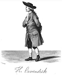
.jpg)
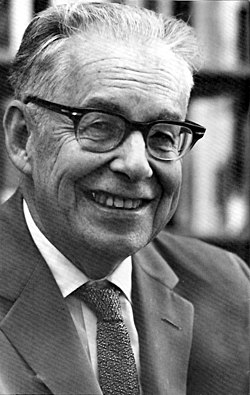
.jpg)
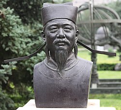
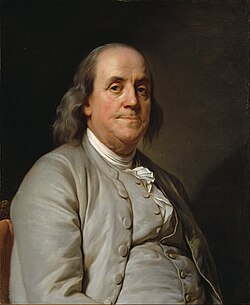
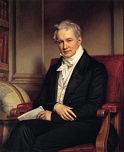
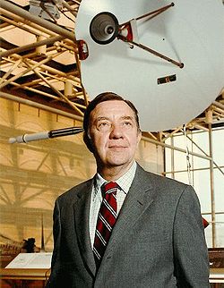
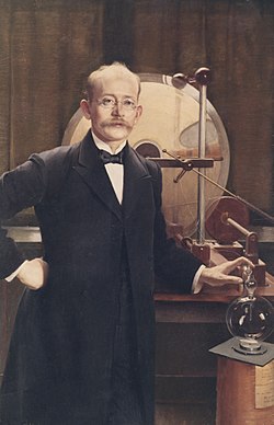
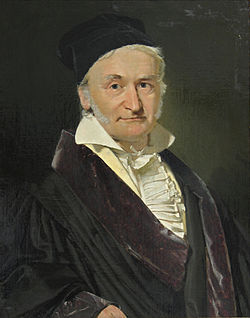
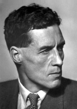
Selected images
-
👁 Image 1Variations in virtual axial dipole moment since the last reversal (from Earth's magnetic field)Variations in virtual axial dipole moment since the last reversal (from Earth's magnetic field)
-
Intensity (from Earth's magnetic field)
-
Lightning sequence (Duration: 0.32 seconds) (from Atmospheric electricity)
-
👁 Image 5Geological cross section of Earth, showing the different layers of the interior. (from Internal structure of Earth)Geological cross section of Earth, showing the different layers of the interior. (from Internal structure of Earth)
-
👁 Image 6An artist's rendering of the structure of a magnetosphere. 1) Bow shock. 2) Magnetosheath. 3) Magnetopause. 4) Magnetosphere. 5) Northern tail lobe. 6) Southern tail lobe. 7) Plasmasphere. (from Earth's magnetic field)An artist's rendering of the structure of a magnetosphere. 1) Bow shock. 2) Magnetosheath. 3) Magnetopause. 4) Magnetosphere. 5) Northern tail lobe. 6) Southern tail lobe. 7) Plasmasphere. (from Earth's magnetic field)
-
👁 Image 8Estimated declination contours by year, 1590 to 1990 (click to see variation) (from Earth's magnetic field)Estimated declination contours by year, 1590 to 1990 (click to see variation) (from Earth's magnetic field)
-
👁 Image 10Schematic representation of spherical harmonics on a sphere and their nodal lines. Pℓ m is equal to 0 along m great circles passing through the poles, and along ℓ-m circles of equal latitude. The function changes sign each ℓtime it crosses one of these lines. (from Earth's magnetic field)Schematic representation of spherical harmonics on a sphere and their nodal lines. Pℓ m is equal to 0 along m great circles passing through the poles, and along ℓ-m circles of equal latitude. The function changes sign each ℓtime it crosses one of these lines. (from Earth's magnetic field)
-
👁 Image 11A concordia diagram as used in uranium–lead dating, with data from the Pfunze Belt, Zimbabwe. All the samples show loss of lead isotopes, but the intercept of the errorchron (straight line through the sample points) and the concordia (curve) shows the correct age of the rock. (from Radiometric dating)A concordia diagram as used in uranium–lead dating, with data from the Pfunze Belt, Zimbabwe. All the samples show loss of lead isotopes, but the intercept of the errorchron (straight line through the sample points) and the concordia (curve) shows the correct age of the rock. (from Radiometric dating)
-
👁 Image 12Thermal ionization mass spectrometer used in radiometric dating. (from Radiometric dating)Thermal ionization mass spectrometer used in radiometric dating. (from Radiometric dating)
-
Apatite crystals are widely used in fission track dating. (from Radiometric dating)
-
👁 Image 14Earth's crust and mantle, Mohorovičić discontinuity between bottom of crust and solid uppermost mantle (from Internal structure of Earth)Earth's crust and mantle, Mohorovičić discontinuity between bottom of crust and solid uppermost mantle (from Internal structure of Earth)
-
Installation for a temporary seismic station, north Iceland highland. (from Seismology)
-
👁 Image 16Strength of the axial dipole component of Earth's magnetic field from 1600 to 2020 (from Earth's magnetic field)Strength of the axial dipole component of Earth's magnetic field from 1600 to 2020 (from Earth's magnetic field)
-
👁 Image 17Computer simulation of the Earth's magnetic field in a period of normal polarity between reversals (from Geophysics)Computer simulation of the Earth's magnetic field in a period of normal polarity between reversals (from Geophysics)
-
👁 Image 18A schematic illustrating the relationship between motion of conducting fluid, organized into rolls by the Coriolis force, and the magnetic field the motion generates. (from Earth's magnetic field)A schematic illustrating the relationship between motion of conducting fluid, organized into rolls by the Coriolis force, and the magnetic field the motion generates. (from Earth's magnetic field)
-
👁 Image 19Background: a set of traces from magnetic observatories showing a magnetic storm in 2000. Globe: map showing locations of observatories and contour lines giving horizontal magnetic intensity in μ T. (from Earth's magnetic field)Background: a set of traces from magnetic observatories showing a magnetic storm in 2000.
Globe: map showing locations of observatories and contour lines giving horizontal magnetic intensity in μ T. (from Earth's magnetic field) -
👁 Image 20World map showing frequency of lightning strikes, in flashes per km2 per year (equal-area projection). Lightning strikes most frequently in the Democratic Republic of the Congo. Combined 1995–2003 data from the Optical Transient Detector and 1998–2003 data from the Lightning Imaging Sensor. (from Atmospheric electricity)World map showing frequency of lightning strikes, in flashes per km2 per year (equal-area projection). Lightning strikes most frequently in the Democratic Republic of the Congo. Combined 1995–2003 data from the Optical Transient Detector and 1998–2003 data from the Lightning Imaging Sensor. (from Atmospheric electricity)
-
👁 Image 21A model of short-wavelength features of Earth's magnetic field, attributed to lithospheric anomalies (from Earth's magnetic field)A model of short-wavelength features of Earth's magnetic field, attributed to lithospheric anomalies (from Earth's magnetic field)
-
👁 Image 22Example of a quadrupole field. This can also be constructed by moving two dipoles together. (from Earth's magnetic field)Example of a quadrupole field. This can also be constructed by moving two dipoles together. (from Earth's magnetic field)
-
👁 Image 23Cloud-to-ground lightning. Typically, lightning discharges 30,000 amperes, at up to 100 million volts, and emits light, radio waves, x-rays and even gamma rays. Plasma temperatures in lightning can approach 28,000 kelvins. (from Atmospheric electricity)Cloud-to-ground lightning. Typically, lightning discharges 30,000 amperes, at up to 100 million volts, and emits light, radio waves, x-rays and even gamma rays. Plasma temperatures in lightning can approach 28,000 kelvins. (from Atmospheric electricity)
-
👁 Image 24Common coordinate systems used for representing the Earth's magnetic field (from Earth's magnetic field)Common coordinate systems used for representing the Earth's magnetic field (from Earth's magnetic field)
-
A photograph of Earth taken by the crew of Apollo 17 in 1972. A processed version became widely known as The Blue Marble. (from Internal structure of Earth)
-
👁 Image 26Geomagnetic polarity during the late Cenozoic Era. Dark areas denote periods where the polarity matches today's polarity, light areas denote periods where that polarity is reversed. (from Earth's magnetic field)Geomagnetic polarity during the late Cenozoic Era. Dark areas denote periods where the polarity matches today's polarity, light areas denote periods where that polarity is reversed. (from Earth's magnetic field)
-
👁 Image 27A depiction of atmospheric electricity in a Martian dust storm, which has been suggested as a possible explanation for enigmatic chemistry results from Mars (see also Viking lander biological experiments) (from Atmospheric electricity)A depiction of atmospheric electricity in a Martian dust storm, which has been suggested as a possible explanation for enigmatic chemistry results from Mars (see also Viking lander biological experiments) (from Atmospheric electricity)
-
👁 Image 28Relationship between Earth's poles. A1 and A2 are the geographic poles; B1 and B2 are the geomagnetic poles; C1 (south) and C2 (north) are the magnetic poles. (from Earth's magnetic field)Relationship between Earth's poles. A1 and A2 are the geographic poles; B1 and B2 are the geomagnetic poles; C1 (south) and C2 (north) are the magnetic poles. (from Earth's magnetic field)
-
Inclination (from Earth's magnetic field)
-
👁 Image 30The movement of Earth's North Magnetic Pole across the North Pole (from Earth's magnetic field)The movement of Earth's North Magnetic Pole across the North Pole (from Earth's magnetic field)
-
👁 Image 31Lu-Hf isochrons plotted of meteorite samples. The age is calculated from the slope of the isochron (line) and the original composition from the intercept of the isochron with the y-axis. (from Radiometric dating)Lu-Hf isochrons plotted of meteorite samples. The age is calculated from the slope of the isochron (line) and the original composition from the intercept of the isochron with the y-axis. (from Radiometric dating)
-
Declination (from Earth's magnetic field)
-
👁 A diagram of Earth's geodynamo and magnetic field, which could have been driven in Earth's early history by the crystallization of magnesium oxide, silicon dioxide, and iron(II) oxide. Convection of Earth's outer core is displayed alongside magnetic field lines.A diagram of Earth's geodynamo and magnetic field, which could have been driven in Earth's early history by the crystallization of magnesium oxide, silicon dioxide, and iron(II) oxide (from Internal structure of Earth)
-
👁 Image 34Schematic view of Earth's interior structure. continental crust oceanic crust upper mantle lower mantle outer core inner core Mohorovičić discontinuity core–mantle boundary outer core–inner core boundary (from Internal structure of Earth)Schematic view of Earth's interior structure.
- upper mantle
- lower mantle
(from Internal structure of Earth)- Mohorovičić discontinuity
- core–mantle boundary
- outer core–inner core boundary
-
👁 Image 35Ale's Stones at Kåseberga, around ten kilometres south east of Ystad, Sweden were dated back to approximately 1,400 years ago using the carbon-14 method on organic material found at the site. (from Radiometric dating)Ale's Stones at Kåseberga, around ten kilometres south east of Ystad, Sweden were dated back to approximately 1,400 years ago using the carbon-14 method on organic material found at the site. (from Radiometric dating)
-
👁 Image 36Computer simulation of Earth's field in a period of normal polarity between reversals. The lines represent magnetic field lines, blue when the field points towards the center and yellow when away. The dense clusters of lines are within Earth's core. (from Earth's magnetic field)Computer simulation of Earth's field in a period of normal polarity between reversals. The lines represent magnetic field lines, blue when the field points towards the center and yellow when away. The dense clusters of lines are within Earth's core. (from Earth's magnetic field)
-
👁 Image 37Example of a radioactive decay chain from lead-212 (212Pb) to lead-208 (208Pb) . Each parent nuclide spontaneously decays into a daughter nuclide (the decay product) via an α decay or a β− decay. The final decay product, lead-208 (208Pb), is stable and can no longer undergo spontaneous radioactive decay. (from Radiometric dating)Example of a radioactive decay chain from lead-212 (212Pb) to lead-208 (208Pb) . Each parent nuclide spontaneously decays into a daughter nuclide (the decay product) via an α decay or a β− decay. The final decay product, lead-208 (208Pb), is stable and can no longer undergo spontaneous radioactive decay. (from Radiometric dating)
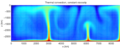
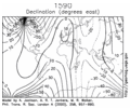
.svg)
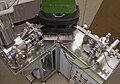
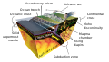
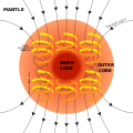
.jpg)
_The_role_of_phosphates_for_the_Lu%E2%80%93Hf_chronology_of_meteorites.gif)
Subcategories
Did you know ...?
- ... that the World Digital Magnetic Anomaly Map depicts features such as the Richat Structure, Atlantic ridge, Paris Basin and Chicxulub crater (pictured)?
- ... that as rocks are compressed, sinking down into an oceanic trench, they release water that causes volcanoes to form above?
- ... that the North geomagnetic pole is not the same as the magnetic North Pole, and that a compass points at neither?
- ... that Suiyo Seamount, a seamount near Japan, was thought to be extinct until a hydrothermal event in 1991 was brought to light?
- ... that Karl Bernhard Zoeppritz was a German geophysicist whose equations use seismic waves to map underground features?
In the news
- 5 December 2019: Earthquakes on the Cascadia Fault may trigger earthquakes on the San Andreas Fault (Nature)
- 10 December 2019/ 20 January 2020: New evidence suggests Earth's magnetic field was present 3.7 billion years ago (Nature) - or perhaps even 4.2 billion years ago (Science)
- 13 January 2020: Brazil opens "spectacular" research base in Antarctica (Science)
Subtopics
Related portals
Associated Wikimedia
The following Wikimedia Foundation sister projects provide more on this subject:
-
Commons
Free media repository -
Wikibooks
Free textbooks and manuals -
Wikidata
Free knowledge base -
Wikinews
Free-content news -
Wikiquote
Collection of quotations -
Wikisource
Free-content library -
Wikiversity
Free learning tools -
Wiktionary
Dictionary and thesaurus
- Pages with German IPA
- Pages using the Phonos extension
- Pages including recorded pronunciations
- Manually maintained portal pages from May 2019
- All manually maintained portal pages
- Portals with triaged subpages from May 2019
- All portals with triaged subpages
- Portals with named maintainer
- Automated article-slideshow portals with 31–40 articles in article list
- Automated article-slideshow portals with 16–20 articles in article list
- Portals missing display of featured content
- Portals needing placement of incoming links