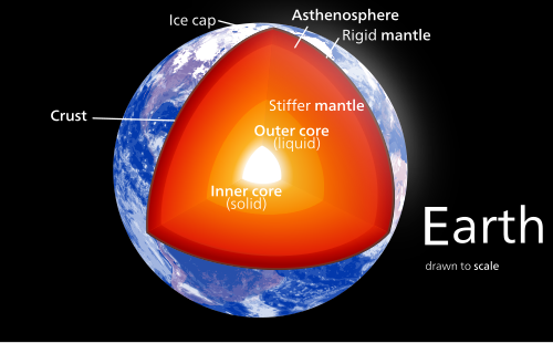
Geology describes the structure of the Earth on and beneath its surface and the processes that have shaped that structure. Geologists study the mineralogical composition of rocks in order to get insight into their history of formation. Geology determines the relative ages of rocks found at a given location; geochemistry (a branch of geology) determines their absolute ages. By combining various petrological, crystallographic, and paleontological tools, geologists are able to chronicle the geological history of the Earth as a whole. One aspect is to demonstrate the age of the Earth. Geology provides evidence for plate tectonics, the evolutionary history of life, and the Earth's past climates.
In a volcanic eruption, lava, volcanic bombs, ash, and various gases are expelled from a volcanic vent and fissure. While many eruptions only pose dangers to the immediately surrounding area, Earth's largest eruptions can have a major regional or even global impact, with some affecting the climate and contributing to mass extinctions. Volcanic eruptions can generally be characterized as either explosive eruptions, sudden ejections of rock and ash, or effusive eruptions, relatively gentle outpourings of lava. A separate list is given below for each type.
There have probably been many such eruptions during Earth's history beyond those shown in these lists. However erosion and plate tectonics have taken their toll, and many eruptions have not left enough evidence for geologists to establish their size. Even for the eruptions listed here, estimates of the volume erupted can be subject to considerable uncertainty. (Full article...)
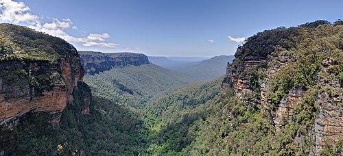
The geology of the Grand Canyon area includes one of the most complete and studied sequences of rock on Earth. The nearly 40 major sedimentary rock layers exposed in the Grand Canyon and in the Grand Canyon National Park area range in age from about 200 million to nearly 2 billion years old. Most were deposited in warm, shallow seas and near ancient, long-gone sea shores in western North America. Both marine and terrestrial sediments are represented, including lithifiedsand dunes from an extinct desert. There are at least 14 known unconformities in the geologic record found in the Grand Canyon.
Uplift of the region started about 75 million years ago during the Laramide orogeny; a mountain-building event that is largely responsible for creating the Rocky Mountains to the east. In total, the Colorado Plateau was uplifted an estimated 2 miles (3.2 km). The adjacent Basin and Range Province to the west started to form about 18 million years ago as the result of crustal stretching. A drainage system that flowed through what is today the eastern Grand Canyon emptied into the now lower Basin and Range province. The opening of the Gulf of California around 6 million years ago enabled a large river to cut its way northeast from the gulf. The new river captured the older drainage to form the ancestral Colorado River, which in turn started to form the Grand Canyon. (Full article...)
The Volcano with thick black scoria in the foreground
The Volcano, also known as Lava Fork volcano, is a small cinder cone in the Boundary Ranges of the Coast Mountains in northwestern British Columbia, Canada. It is located approximately 60 kilometres (40 miles) northwest of the small community of Stewart near the head of Lava Fork. With an elevation of 1,656 metres (5,433 feet) and a topographic prominence of 311 m (1,020 ft), it rises above the surrounding rugged landscape on a remote mountain ridge that represents the northern flank of a glaciated U-shaped valley.
Lava Fork volcano is associated with a small group of volcanoes called the Iskut volcanic field. This forms part of the much larger Northern Cordilleran Volcanic Province, which extends from the Alaska–Yukon border to near the port city of Prince Rupert, British Columbia. Eruptive activity at The Volcano is relatively young compared to most other volcanoes in the Northern Cordilleran Volcanic Province. Geologic studies have shown that The Volcano and its eruptive products were emplaced in the last 400 years; this is well after the last glacial period, which ended about 10,000 years ago. (Full article...)
The first magmatic cycle took place between 7.5 and 6 million years ago and is represented by the Raspberry, Little Iskut and Armadillo formations, each of which is the product of a different eruptive period. Three distinct periods of eruptive activity also characterized the second magmatic cycle between 6 and 1 million years ago; they are represented by the Nido, Spectrum and Pyramid geological formations. The third magmatic cycle about 1 million years ago is represented by the Ice Peak, Pillow Ridge and Edziza geological formations, each of which is also the product of a distinct eruptive period. Three distinct periods of eruptive activity also characterized the fourth magmatic cycle between 0.8 and 0.2 million years ago which are represented by the Arctic Lake, Klastline and Kakiddi geological formations. The fifth magmatic cycle began at least 20,000 years ago and may be ongoing; the single distinct eruptive period of this magmatic cycle is represented by the Big Raven Formation. (Full article...)
The earthquake had a maximum perceived intensity of VII (Very strong) on the Mercalli intensity scale. It caused minor damage, reports of which were confined to Kansas, Iowa, and Missouri, according to the United States Geological Survey. Felt over an area of 200,000 square miles (520,000 km2), the earthquake reached the states of Indiana, Illinois, and possibly Ohio, though the latter reports have been questioned. (Full article...)
Anning searched for fossils in the area's Blue Lias and Charmouth Mudstone cliffs, particularly during the winter months when landslides exposed new fossils that had to be collected quickly before they were lost to the sea. Her discoveries included the first correctly identified ichthyosaur skeleton when she was twelve years old; the first two nearly complete plesiosaur skeletons; the first pterosaur skeleton located outside Germany; and fish fossils. Her observations played a key role in the discovery that coprolites, known as bezoar stones at the time, were fossilised faeces, and she also discovered that belemnite fossils contained fossilised ink sacs like those of modern cephalopods. (Full article...)
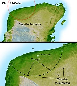
Imaging from NASA's Shuttle Radar Topography Mission STS-99 reveals part of the diameter ring of the crater in the form of a shallow circular trough. Numerous cenotes (sinkholes) cluster around the trough marking the inner crater rim.
The Chicxulub crater is an impact crater buried underneath the Yucatán Peninsula in Mexico. Its center is offshore, but the crater is named after the onshore community of Chicxulub Pueblo (not to be confused with the larger coastal town of Chicxulub Puerto). It was formed slightly over 66 million years ago when an asteroid, about ten kilometers (six miles) in diameter, struck Earth. The crater is estimated to be 200 kilometers (120 miles) in diameter and is buried to a depth of about 1 kilometer (0.62 miles) beneath younger sedimentary rocks. It is one of the largest impact structures on Earth, alongside the much older Sudbury and Vredefort impact structures, and the only one whose peak ring is intact and directly accessible for scientific research.
The crater was discovered by Antonio Camargo and Glen Penfield, geophysicists who had been looking for petroleum in the Yucatán Peninsula during the late 1970s. Penfield was initially unable to obtain evidence that the geological feature was a crater and gave up his search. Later, through contact with Alan R. Hildebrand in 1990, Penfield obtained samples that suggested it was an impact feature. Evidence for the crater's impact origin includes shocked quartz, a gravity anomaly, and tektites in surrounding areas. (Full article...)
👁 Image An earthquake struck northern Iran's Khorasan Province in the vicinity of Qaen on May 10, 1997, at 07:57 UTC (12:57 local time). The largest in the area since 1990, the earthquake registered 7.3 on the moment magnitude scale and was centered approximately 270 kilometers (170 mi) south of Mashhad on the village of Ardekul. The third earthquake that year to cause severe damage, it devastated the Birjand–Qayen region, killing 1,567 and injuring more than 2,300. The earthquake—which left 50,000 homeless and damaged or destroyed over 15,000 homes—was described as the deadliest of 1997 by the United States Geological Survey. Some 155 aftershocks caused further destruction and drove away survivors. The earthquake was later discovered to have been caused by a rupture along a fault that runs underneath the Iran–Afghanistan border.
Damage was eventually estimated at $100 million, and many countries responded to the emergency with donations of blankets, tents, clothing, and food. Rescue teams were also dispatched to assist local volunteers in finding survivors trapped under the debris. The destruction around the earthquake's epicenter was, in places, almost total; this has been attributed to poor construction practices in rural areas, and imparted momentum to a growing movement for changes in building codes for earthquake-safe buildings. With 1 in 3,000 deaths in Iran attributable to earthquakes, a US geophysicist has suggested that a country-wide rebuilding program would be needed to address the ongoing public safety concerns. (Full article...)
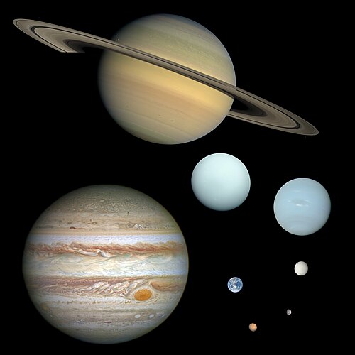
The word planet comes from the Greek πλανήται (planḗtai) 'wanderers'. In antiquity, this word referred to the Sun, Moon, and five points of light visible to the naked eye that moved across the background of the stars—namely, Mercury, Venus, Mars, Jupiter, and Saturn. Planets have historically had religious associations: multiple cultures identified celestial bodies with gods, and these connections with mythology and folklore persist in the schemes for naming newly discovered Solar System bodies. Earth itself was recognized as a planet when heliocentrism supplanted geocentrism during the 16th and 17th centuries. (Full article...)
In 1257, a catastrophic eruption occurred at Samalas, a volcano on the Indonesian island of Lombok. The event had a probable Volcanic Explosivity Index of 7, making it one of the largest volcanic eruptions during the Holocene epoch. It left behind a large caldera that contains Lake Segara Anak. Later volcanic activity created more volcanic centres in the caldera, including the Barujari cone, which remains active. (Full article...)
... that Frederick Murray Trotter had a distinguished career as a field geologist despite losing a part of his skull and an eye to shrapnel during World War I?
... that English amateur geologist Charlotte Eyton wrote a number of papers and pamphlets on the geology of the Wrekin, a part of Shropshire, between 1862 and 1870?
Top 10 WikiProject Geology Popular articles of the month
👁 Image Animated, colour-coded map showing four to seven continents – depending on the convention and model, some continents may be consolidated or subdivided.
A continent is any of several large terrestrial geographical regions. Continents are generally identified by convention rather than any strict criteria. A continent could be a single large landmass, a landmass and nearby islands either on or beyond its continental shelf, or a part of a larger landmass, as in the case of Asia and Europe within Eurasia. Due to these varying definitions, the number of continents varies, up to seven or as few as four. Most English-speaking countries recognize seven continents. In order from largest to smallest in area, these seven are Asia, Africa, North America, South America, Antarctica, Europe, and Australia (or sometimes Oceania or Australasia). Different variations with fewer continents merge some of these regions; examples of this are merging Asia and Europe into Eurasia, North America and South America into the Americas (or simply America), and Africa, Asia, and Europe into Afro-Eurasia. (Full article...)
Mount Everest (known locally as Sagarmāthā in Nepal and Qomolangma in Tibet) is Earth's highest mountain above sea level. It lies in the Mahalangur Himal sub-range of the Himalayas and marks part of the China–Nepal border at its summit. Its height was most recently measured in 2020 by Chinese and Nepali authorities as 8,848.86 m (29,031 ft 8+1⁄2 in). (Full article...)
Imaging from NASA's Shuttle Radar Topography Mission STS-99 reveals part of the diameter ring of the crater in the form of a shallow circular trough. Numerous cenotes (sinkholes) cluster around the trough marking the inner crater rim.
The Chicxulub crater is an impact crater buried underneath the Yucatán Peninsula in Mexico. Its center is offshore, but the crater is named after the onshore community of Chicxulub Pueblo (not to be confused with the larger coastal town of Chicxulub Puerto). It was formed slightly over 66 million years ago when an asteroid, about ten kilometers (six miles) in diameter, struck Earth. The crater is estimated to be 200 kilometers (120 miles) in diameter and is buried to a depth of about 1 kilometer (0.62 miles) beneath younger sedimentary rocks. It is one of the largest impact structures on Earth, alongside the much older Sudbury and Vredefort impact structures, and the only one whose peak ring is intact and directly accessible for scientific research. (Full article...)
The Mariana Trench is an oceanic trench located in the western Pacific Ocean, about 200 kilometres (124 mi) east of the Mariana Islands; it is the deepest oceanic trench on Earth. It is crescent-shaped and measures about 2,550 km (1,580 mi) in length and 69 km (43 mi) in width. The maximum known depth is 10,984 ± 25 metres (36,037 ± 82 ft; 6,006 ± 14 fathoms; 6.825 ± 0.016 mi) at the southern end of a small slot-shaped valley in its floor known as the Challenger Deep. The deepest point of the trench is more than 2 km (1.2 mi) farther from sea level than the peak of Mount Everest. (Full article...)
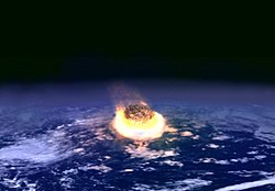
👁 Image The Cretaceous–Paleogene (K–Pg) extinction event, formerly known as the Cretaceous-Tertiary (K–T) extinction event, was a major mass extinction of three-quarters of the plant and animal species on Earth which occurred approximately 66 million years ago. The event caused the extinction of all of the non-avian dinosaurs and most other tetrapods weighing more than 25 kg (55 lb), with the exception of some ectothermic species such as sea turtles and crocodilians. It marked the end of the Cretaceous period, and with it the Mesozoic era, while heralding the beginning of the current geological era, the Cenozoic Era. In the geologic record, the K–Pg event is marked by a thin layer of sediment called the K–Pg boundary or K–T boundary, which can be found throughout the world in marine and terrestrial rocks. The boundary clay shows unusually high levels of the metal iridium, which is more common in asteroids than in the Earth's crust. (Full article...)
A geological map of Yosemite National Park (full size), showing the Cathedral Peak Granodiorite, the largest unit in the Tuolumne Intrusive Suite, which in turn is the largest granitic suite in the park. Cathedral Peak Granodiorite Rest of the Tuolumne Intrusive Suite
Curiosity is a car-sized rover designed to explore the crater Gale on Mars as part of NASA's Mars Science Laboratory mission. It was launched from Cape Canaveral in November 2011 and landed on Aeolis Palus inside Gale on August 6, 2012, at 05:17 UTC. Curiosity's landing site, nicknamed Bradbury Landing, was less than 2.4 km (1.5 mi) from the center of the rover's touchdown target after a 560-million km (350-million mi) journey. The rover's goals include an investigation of the Martian climate and geology; assessment of whether the selected field site inside Gale has ever offered environmental conditions favorable for microbial life, including investigation of the role of water; as well as planetary habitability studies in preparation for human exploration.
This picture is a self-portrait of Curiosity on Mars at the "Big Sky" drilling site, where it collected a rock sample at the foothills of Aeolis Mons (Mount Sharp) in October 2015. The photograph combines dozens of images taken by the Mars Hand Lens Imager (MAHLI) camera at the end of the rover's robotic arm; the arm itself is not included, although its shadow is visible on the ground. Wrist motions and turret rotations on the arm allowed MAHLI to acquire the mosaic's component images.
This false-color mosaic showing compositional variations in the geology of the Moon was constructed from a series of 53 images taken through three spectral filters by the imaging system of the Galileo spacecraft. Bright pinkish areas are highlands materials, such as those surrounding the oval lava-filled Mare Crisiumimpact basin toward the bottom. Blue to orange shades indicate volcanic lava flows. To the left of Crisium, the dark blue Mare Tranquillitatis is richer in titanium than the green and orange maria above it. Thin mineral-rich soils associated with relatively recent impacts are represented by light blue colors. The monochrome band on the right edge shows the unretouched surface of the moon.
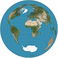
The Lambert azimuthal equal-area projection is a projection used for mapping a sphere to a disk. It accurately represents area in all regions of the sphere, but it does not accurately represent angles. It is used in scientific disciplines such as geology for plotting the orientations of lines in three-dimensional space, and by the National Atlas of the US in its online map-making application.

.jpg)
.svg)
.svg)
.png)