
The Oceans Portal
A portal dedicated to oceans, seas, oceanography and related topics
– Hover over image and scroll to middle for controls to see more selected panorama images –
-
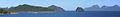
👁 Image
A view of the South China Sea, Bacuit Archipelago, municipality of El Nido, Palawan, Philippines -
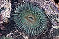
👁 Image
A sea anemone in the Pacific Ocean, Baja California, Mexico -
👁 Image
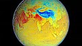
Satellite view of the Pacific Ocean and the main windward Hawaiian Islands -
👁 Image
Caesio teres in the South Pacific Ocean in Fiji -
👁 A view of Filfla and the Mediterranean Sea. Filfla is a small, mostly barren, uninhabited islet 4.5 kilometres (2.8 miles) south of Malta.👁 Image
A view of Filfla and the Mediterranean Sea. Filfla is a small, mostly barren, uninhabited islet 4.5 kilometres (2.8 miles) south of Malta. -
👁 Image
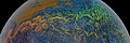
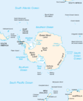
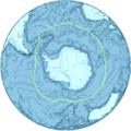
Clouds over the Southern Ocean, with continent labels -
👁 Image
A mother sperm whale and her calf in the Indian Ocean off the coast of Mauritius -
👁 A view of the Southern Ocean from Great Ocean Road, Port Campbell, Princetown, Victoria, Australia👁 Image
A view of the Southern Ocean from Great Ocean Road, Port Campbell, Princetown, Victoria, Australia -
👁 Image
Icebergs broken off from glaciers in northern Baffin Bay, Cape York, Greenland -
👁 Image
Orca (Orcinus orca) hunting a Weddell seal in the Southern Ocean -
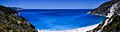
👁 Image
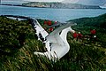
A view of Myrtos Beach and the Ionian Sea, Cephalonia, Ionian Islands, Greece -
👁 Image
A panorama of Zanzibar, Tanzania, particularly the Stone Town, taken from the Indian Ocean -
👁 A surfer in the Pacific Ocean at the 2010 Mavericks competition, village of Princeton-by-the-Sea, northern California👁 Image
A surfer in the Pacific Ocean at the 2010 Mavericks competition, village of Princeton-by-the-Sea, northern California
.jpg)
.jpeg)
Introduction
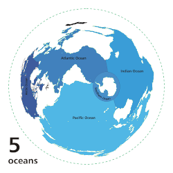
| Earth's ocean |
|---|
|
Main five oceans division: Further subdivision: Marginal seas |
The ocean is the body of salt water that covers approximately 70.8% of Earth. The ocean is conventionally divided into large bodies of water, which are also referred to as oceans (in descending order by area: the Pacific Ocean, the Atlantic Ocean, the Indian Ocean, the Antarctic/Southern Ocean, and the Arctic Ocean), and are themselves mostly divided into seas, gulfs and subsequent bodies of water. The ocean contains 97% of Earth's water and is the primary component of Earth's hydrosphere, acting as a huge reservoir of heat for Earth's energy budget, as well as for its carbon cycle and water cycle, forming the basis for climate and weather patterns worldwide. The ocean is essential to life on Earth, harbouring most of Earth's animals and protist life, originating photosynthesis and therefore Earth's atmospheric oxygen, still supplying half of it. (Full article...)
A sea is a large body of salt water. There are particular seas and the sea. The sea commonly refers to the ocean, the interconnected body of seawaters that spans most of Earth. Particular seas are either marginal seas, second-order sections of the oceanic sea (e.g. the Mediterranean Sea), or certain large, nearly landlocked bodies of water. (Full article...)
Oceanography (from Ancient Greek ὠκεανός (ōkeanós) 'ocean' and γραφή (graphḗ) 'writing'), also known as oceanology, sea science, ocean science, and marine science, is the scientific study of the ocean, including its physics, chemistry, biology, and geology. (Full article...)
Selected article - show another
Marine mammals are mammals that rely on marine ecosystems for their existence. They include animals such as cetaceans, pinnipeds, sirenians, marine otters, sea otters and polar bears. They are an informal group, unified only by their reliance on marine environments for feeding and survival.
Marine mammal adaptation to an aquatic lifestyle varies considerably between species. Both cetaceans and sirenians are fully aquatic and therefore are obligate water dwellers. Pinnipeds are semiaquatic; they spend the majority of their time in the water but need to return to land for important activities such as mating, breeding and molting. Sea otters tend to live in kelp forests and estuaries. In contrast, the polar bear is mostly terrestrial and only goes into the water on occasions of necessity, and are thus much less adapted to aquatic living. The diets of marine mammals vary considerably as well; some eat zooplankton, others eat fish, squid, shellfish, or seagrass, and a few eat other mammals. While the number of marine mammals is small compared to those found on land, their roles in various ecosystems are large, especially concerning the maintenance of marine ecosystems, through processes including the regulation of prey populations. This role in maintaining ecosystems makes them of particular concern as 23% of marine mammal species are currently threatened. (Full article...)
Interesting facts - show different entries
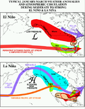
- The National Oceanic and Atmospheric Administration began reanalyzing Atlantic hurricane data in 2006 to correct errors in the hurricane database dating back to the Apollo Program
- Hurricane Alberto of 2000 completed the largest loop ever observed over the Atlantic Ocean.
- Underwater explosions produce ocean surface waves that are similar to tsunamis.
Selected list articles and Marine habitat topics
| Marine habitats |
|---|
| Coastal habitats |
| Ocean surface |
| Open ocean |
| Sea floor |
- List of oceans
- List of ancient oceans
- List of seas
- List of circumnavigations
- List of cruise lines
- List of largest lakes and seas in the Solar System
- List of marine biologists
- List of marine ecoregions
- List of maritime explorers
- List of naval battles
- List of ocean liners
- List of oceanographic institutions and programs
- List of oldest surviving ships
- List of rogue waves
- List of seafood dishes
- List of submarine topographical features
Tasks
General images - show new batch
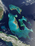
-
Bahama Banks (from Atlantic Ocean)
-
👁 Image 2A Chagossian on Diego Garcia in 1971, before the British expelled the islanders. He spoke a French-based creole language and his ancestors were likely brought as slaves in the 19th century. (from Indian Ocean)A Chagossian on Diego Garcia in 1971, before the British expelled the islanders. He spoke a French-based creole language and his ancestors were likely brought as slaves in the 19th century. (from Indian Ocean)
-
👁 Image 3Made in 1529, the Diogo Ribeiro map was the first to show the Pacific at about its proper size (from Pacific Ocean)Made in 1529, the Diogo Ribeiro map was the first to show the Pacific at about its proper size (from Pacific Ocean)
-
👁 Image 4According to the Coastal hypothesis, modern humans spread from Africa along the northern rim of the Indian Ocean. (from Indian Ocean)According to the Coastal hypothesis, modern humans spread from Africa along the northern rim of the Indian Ocean. (from Indian Ocean)
-
👁 Image 5Model of a Fijian drua, an example of an Austronesian vessel with a double-canoe (catamaran) hull and a crab claw sail (from Pacific Ocean)Model of a Fijian drua, an example of an Austronesian vessel with a double-canoe (catamaran) hull and a crab claw sail (from Pacific Ocean)
-
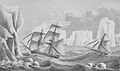
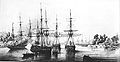
👁 Image 6James Weddell's second expedition in 1823, depicting the brig Jane and the cutter Beaufroy (from Southern Ocean)James Weddell's second expedition in 1823, depicting the brig Jane and the cutter Beaufroy (from Southern Ocean)
-
👁 Image 7"Southern Ocean" as alternative to the Aethiopian Ocean, 18th century (from Southern Ocean)"Southern Ocean" as alternative to the Aethiopian Ocean, 18th century (from Southern Ocean)
-
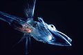
👁 Image 8Fish of the Notothenioidei suborder, such as this young icefish, are mostly restricted to the Antarctic and Subantarctic. (from Southern Ocean)Fish of the Notothenioidei suborder, such as this young icefish, are mostly restricted to the Antarctic and Subantarctic. (from Southern Ocean)
-
👁 Image 9The Antarctic Circumpolar Current (ACC) is the strongest current system in the world oceans, linking the Atlantic, Indian and Pacific basins. (from Southern Ocean)The Antarctic Circumpolar Current (ACC) is the strongest current system in the world oceans, linking the Atlantic, Indian and Pacific basins. (from Southern Ocean)
-
👁 Image 10Universalis Cosmographia, also known as the Waldseemüller map, dated 1507, was the first map to show the Americas separating two distinct oceans. South America was generally considered the New World and shows the name "America" for the first time, after Amerigo Vespucci (from Pacific Ocean)Universalis Cosmographia, also known as the Waldseemüller map, dated 1507, was the first map to show the Americas separating two distinct oceans. South America was generally considered the New World and shows the name "America" for the first time, after Amerigo Vespucci (from Pacific Ocean)
-
USS Vincennes at Disappointment Bay, Antarctica in early 1840 (from Southern Ocean)
-
👁 Image 12Map of the Pacific Ocean during European Exploration, circa 1702–1707 (from Pacific Ocean)Map of the Pacific Ocean during European Exploration, circa 1702–1707 (from Pacific Ocean)
-
👁 Visualisation of the Gulf Stream stretching from the Gulf of Mexico to Western Europe (from Atlantic Ocean)As the Gulf Stream meanders across the North Atlantic from the North American east coast to Western Europe its temperature drops by 20 °C (36 °F).
-
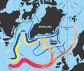
👁 Image 14In the subpolar gyre of the North Atlantic warm subtropical waters are transformed into colder subpolar and polar waters. In the Labrador Sea this water flows back to the subtropical gyre. (from Atlantic Ocean)In the subpolar gyre of the North Atlantic warm subtropical waters are transformed into colder subpolar and polar waters. In the Labrador Sea this water flows back to the subtropical gyre. (from Atlantic Ocean)
-
Capture of Atlantic northwest cod in million tons (from Atlantic Ocean)
-
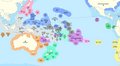
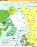
👁 Image 18The Arctic region showing the Northeast Passage, the Northern Sea Route within it, and the Northwest Passage via Canadian Inland Waters. (from Arctic Ocean)The Arctic region showing the Northeast Passage, the Northern Sea Route within it, and the Northwest Passage via Canadian Inland Waters. (from Arctic Ocean)
-
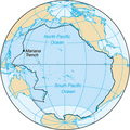
👁 Image 19The bathyscaphe Trieste before her record dive to the bottom of the Mariana Trench, 23 January 1960 (from Pacific Ocean)The bathyscaphe Trieste before her record dive to the bottom of the Mariana Trench, 23 January 1960 (from Pacific Ocean)
-
1928 delineation (from Southern Ocean)
-
Minke whale (from Arctic Ocean)
-
Pacific Ocean currents have created three islands of debris. (from Pacific Ocean)
-
Map of the Pacific Ocean during European Exploration, circa 1754. (from Pacific Ocean)
-
Continents and islands of the Southern Ocean (from Southern Ocean)
-
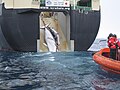
👁 Image 26An adult and sub-adult Minke whale are dragged aboard the Japanese whaling vessel Nisshin Maru. (from Southern Ocean)An adult and sub-adult Minke whale are dragged aboard the Japanese whaling vessel Nisshin Maru. (from Southern Ocean)
-
False color map of ocean depth in the Atlantic basin (from Atlantic Ocean)
-
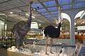
👁 Image 28Madagascar's elephant bird, Mauritius's dodo bird and ostrich (from left to right) (from Indian Ocean)Madagascar's elephant bird, Mauritius's dodo bird and ostrich (from left to right) (from Indian Ocean)
-
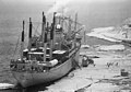
👁 Image 29Severe cracks in an ice pier in use for four seasons at McMurdo Station slowed cargo operations in 1983 and proved a safety hazard. (from Southern Ocean)Severe cracks in an ice pier in use for four seasons at McMurdo Station slowed cargo operations in 1983 and proved a safety hazard. (from Southern Ocean)
-
"Terres Australes" [sic] label without any charted landmass (from Southern Ocean)
-
An exclusive economic zone (EEZ) map of the Pacific (from Pacific Ocean)
-
👁 Image 32MS Explorer in Antarctica in January 1999. She sank on 23 November 2007 after hitting an iceberg. (from Southern Ocean)MS Explorer in Antarctica in January 1999. She sank on 23 November 2007 after hitting an iceberg. (from Southern Ocean)
-
👁 Image 33Embarked and disembarked slaves in the Atlantic slave trade 1525–1863 (first and last slave voyages) (from Atlantic Ocean)Embarked and disembarked slaves in the Atlantic slave trade 1525–1863 (first and last slave voyages) (from Atlantic Ocean)
-
👁 Image 35The Antarctic Ocean, as delineated by the draft 4th edition of the International Hydrographic Organization's Limits of Oceans and Seas (2002) (from Southern Ocean)The Antarctic Ocean, as delineated by the draft 4th edition of the International Hydrographic Organization's Limits of Oceans and Seas (2002) (from Southern Ocean)
-
👁 Image 36A Ring of Fire; the Pacific is ringed by many volcanoes and oceanic trenches. This map does not show the Cascadia subduction zone along part of the west coast of North America, whose trench is completely buried in sediments. (from Pacific Ocean)A Ring of Fire; the Pacific is ringed by many volcanoes and oceanic trenches. This map does not show the Cascadia subduction zone along part of the west coast of North America, whose trench is completely buried in sediments. (from Pacific Ocean)
-
👁 Image 37The Austronesian maritime trade network was the first trade routes in the Indian Ocean. (from Indian Ocean)The Austronesian maritime trade network was the first trade routes in the Indian Ocean. (from Indian Ocean)
-
Walruses on Arctic ice floe (from Arctic Ocean)
-
👁 Map of Caribbean showing seven approximately parallel westward-pointing arrows that extend from east of the Virgin Islands to Cuba. The southern arrows bend northward just east of the Dominican Republic before straightening out again. (from Atlantic Ocean)Waves in the trade winds in the Atlantic Ocean – areas of converging winds that move along the same track as the prevailing wind – create instabilities in the atmosphere that may lead to the formation of hurricanes.
-
Agulhas Bank (from Atlantic Ocean)
-
👁 Image 42The International Hydrographic Organization's delineation of the "Southern Ocean" has moved steadily southward since the original 1928 edition of its Limits of Oceans and Seas. (from Southern Ocean)The International Hydrographic Organization's delineation of the "Southern Ocean" has moved steadily southward since the original 1928 edition of its Limits of Oceans and Seas. (from Southern Ocean)
-
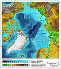
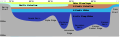
👁 Image 43Distribution of the major water mass in the Arctic Ocean. The section sketches the different water masses along a vertical section from Bering Strait over the geographic North Pole to Fram Strait. As the stratification is stable, deeper water masses are denser than the layers above. (from Arctic Ocean)Distribution of the major water mass in the Arctic Ocean. The section sketches the different water masses along a vertical section from Bering Strait over the geographic North Pole to Fram Strait. As the stratification is stable, deeper water masses are denser than the layers above. (from Arctic Ocean)
-
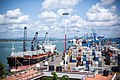
Mombasa Port on Kenya's Indian Ocean coast (from Indian Ocean)
-
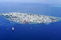
👁 Image 45Malé's population has increased from 20,000 people in 1987 to more than 220,000 people in 2020. (from Indian Ocean)Malé's population has increased from 20,000 people in 1987 to more than 220,000 people in 2020. (from Indian Ocean)
-
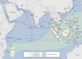
👁 Image 47Major ocean trade routes in the world include the northern Indian Ocean. (from Indian Ocean)Major ocean trade routes in the world include the northern Indian Ocean. (from Indian Ocean)
-
👁 Image 48Famous official portrait of Captain James Cook who proved that waters encompassed the southern latitudes of the globe. "He holds his own chart of the Southern Ocean on the table and his right hand points to the east coast of Australia on it." (from Southern Ocean)Famous official portrait of Captain James Cook who proved that waters encompassed the southern latitudes of the globe. "He holds his own chart of the Southern Ocean on the table and his right hand points to the east coast of Australia on it." (from Southern Ocean)
-
👁 Image 49The Atlantic Gyres influenced the Portuguese discoveries and trading port routes, here shown in the India Run ("Carreira da Índia"), which would be developed in subsequent years. (from Atlantic Ocean)The Atlantic Gyres influenced the Portuguese discoveries and trading port routes, here shown in the India Run ("Carreira da Índia"), which would be developed in subsequent years. (from Atlantic Ocean)
-
👁 Image 50Maris Pacifici by Ortelius (1589). One of the first printed maps to show the Pacific Ocean (from Pacific Ocean)Maris Pacifici by Ortelius (1589). One of the first printed maps to show the Pacific Ocean (from Pacific Ocean)
-
1911 South Polar Regions exploration map (from Southern Ocean)
-
👁 Image 52Based on the medieval Íslendingasögur sagas, including the Grœnlendinga saga, this interpretative map of the "Norse World" shows that Norse knowledge of the Americas and the Atlantic remained limited. (from Atlantic Ocean)Based on the medieval Íslendingasögur sagas, including the Grœnlendinga saga, this interpretative map of the "Norse World" shows that Norse knowledge of the Americas and the Atlantic remained limited. (from Atlantic Ocean)
-
👁 Image 53In 2020, Japanese Prime Minister Suga declined to drink the bottle of Fukushima's treated radioactive water that he was holding, which would otherwise be discharged to the Pacific. (from Pacific Ocean)In 2020, Japanese Prime Minister Suga declined to drink the bottle of Fukushima's treated radioactive water that he was holding, which would otherwise be discharged to the Pacific. (from Pacific Ocean)
-
👁 Image 54Weddell seals (Leptonychotes weddellii) are the most southerly of Antarctic mammals. (from Southern Ocean)Weddell seals (Leptonychotes weddellii) are the most southerly of Antarctic mammals. (from Southern Ocean)
-
👁 Image 55A map of Australia's official interpretation of the names and limits of oceans and seas around Australia (from Southern Ocean)A map of Australia's official interpretation of the names and limits of oceans and seas around Australia (from Southern Ocean)
-
👁 Image 56The British invasion of Isle de France on 29 November 1810 during the Napoleonic Wars (from Indian Ocean)The British invasion of Isle de France on 29 November 1810 during the Napoleonic Wars (from Indian Ocean)
-
Coral reefs of the Maldives (from Indian Ocean)
-
Excavation of the Ertebølle middens in 1880 (from Atlantic Ocean)
-
Admiral von Bellingshausen (from Southern Ocean)
-
👁 Image 63Area inside the black line indicates the area constituting the Pacific Ocean prior to 2002; darker blue areas are its informal current borders following the recreation of the Southern Ocean and the reinclusion of marginal seas. (from Southern Ocean)Area inside the black line indicates the area constituting the Pacific Ocean prior to 2002; darker blue areas are its informal current borders following the recreation of the Southern Ocean and the reinclusion of marginal seas. (from Southern Ocean)
-
Location of the Southern Ocean gyres (from Southern Ocean)
-
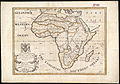
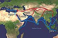
👁 Image 66The economically important Silk Road was blocked from Europe by the Ottoman Empire in c. 1453 with the fall of the Byzantine Empire. This spurred exploration, and a new sea route around Africa was found, triggering the Age of Discovery. (from Indian Ocean)The economically important Silk Road was blocked from Europe by the Ottoman Empire in c. 1453 with the fall of the Byzantine Empire. This spurred exploration, and a new sea route around Africa was found, triggering the Age of Discovery. (from Indian Ocean)
-
Typhoon Tip at global peak intensity on 12 October 1979 (from Pacific Ocean)
-
Banks of the northeast Atlantic (from Atlantic Ocean)
-
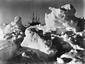
👁 Image 69Frank Hurley: As time wore on it became more and more evident that the ship was doomed (Endurance trapped in pack ice), National Library of Australia. (from Southern Ocean)Frank Hurley: As time wore on it became more and more evident that the ship was doomed (Endurance trapped in pack ice), National Library of Australia. (from Southern Ocean)
-
👁 Image 70The three major cultural areas of the Pacific Ocean islands: Micronesia, Melanesia and Polynesia (from Pacific Ocean)The three major cultural areas of the Pacific Ocean islands: Micronesia, Melanesia and Polynesia (from Pacific Ocean)
-
Cod fishery in Norway (from Atlantic Ocean)
-
👁 Image 72For most of the 16th century, the Portuguese dominated the Indian Ocean trade. (from Indian Ocean)For most of the 16th century, the Portuguese dominated the Indian Ocean trade. (from Indian Ocean)
-
The island geography of the Pacific Ocean Basin (from Pacific Ocean)
-
👁 Image 74Greco-Roman trade with ancient India according to the Periplus of the Erythraean Sea 1st century CE (from Indian Ocean)Greco-Roman trade with ancient India according to the Periplus of the Erythraean Sea 1st century CE (from Indian Ocean)
-
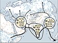
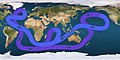
👁 Map displaying a looping line with arrows indicating that water flows eastward in the far Southern Ocean, angling northeast of Australia, turning sough-after passing Alaska, then crossing the mid-Pacific to flow north of Australia, continuing west below Africa, then turning northwest until reaching eastern Canada, then angling east to southern Europe, then finally turning south just below Greenland and flowing down the Americas' eastern coast, and resuming its flow eastward to complete the circle (from Atlantic Ocean)Path of the thermohaline circulation. Purple paths represent deep-water currents, while blue paths represent surface currents.
-
👁 Image 77On the sea ice of the Arctic Ocean temporary logistic stations may be installed. Here, a Twin Otter is refueled on the pack ice at 86°N, 76°43‘W. on April 16, 1990 during a flight to the North Pole (from Arctic Ocean)On the sea ice of the Arctic Ocean temporary logistic stations may be installed. Here, a Twin Otter is refueled on the pack ice at 86°N, 76°43‘W. on April 16, 1990 during a flight to the North Pole (from Arctic Ocean)
-
👁 Image 78The Arctic Ocean, with borders as delineated by the International Hydrographic Organization (IHO), including Hudson Bay (some of which is south of 57°N latitude, off the map) and all other marginal seas. (from Arctic Ocean)The Arctic Ocean, with borders as delineated by the International Hydrographic Organization (IHO), including Hudson Bay (some of which is south of 57°N latitude, off the map) and all other marginal seas. (from Arctic Ocean)
-
Seas that are parts of the Southern Ocean (from Southern Ocean)
-
👁 Image 81Marine debris strewn over the beaches of the South Atlantic Inaccessible Island (from Atlantic Ocean)Marine debris strewn over the beaches of the South Atlantic Inaccessible Island (from Atlantic Ocean)
-
👁 Image 83Sea cover in the Arctic Ocean, showing the median, 2005 and 2007 coverage (from Arctic Ocean)Sea cover in the Arctic Ocean, showing the median, 2005 and 2007 coverage (from Arctic Ocean)
-
Manganese nodule (from Southern Ocean)
-
👁 Image 85The Arctic region; of note, the region's southerly border on this map is depicted by a red isotherm, with all territory to the north having an average temperature of less than 10 °C (50 °F) in July. (from Arctic Ocean)The Arctic region; of note, the region's southerly border on this map is depicted by a red isotherm, with all territory to the north having an average temperature of less than 10 °C (50 °F) in July. (from Arctic Ocean)
-
The Kennedy Channel. (from Arctic Ocean)
-
👁 Image 87The 1564 Typus Orbis Terrarum, a map by Abraham Ortelius, showed the imagined link between the proposed continent of Antarctica and South America. (from Southern Ocean)The 1564 Typus Orbis Terrarum, a map by Abraham Ortelius, showed the imagined link between the proposed continent of Antarctica and South America. (from Southern Ocean)
-
1937 delineation (from Southern Ocean)
-
Banks of the northwest Atlantic (from Atlantic Ocean)
-
Sunset in Monterey County, California, U.S. (from Pacific Ocean)
-
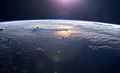
👁 Image 91Sunset over the Pacific Ocean as seen from the International Space Station. Tops of thunderclouds are also visible. (from Pacific Ocean)Sunset over the Pacific Ocean as seen from the International Space Station. Tops of thunderclouds are also visible. (from Pacific Ocean)
-
👁 Image 92An iceberg being pushed out of a shipping lane by (L to R) USS Burton Island, USS Atka, and USS Glacier near McMurdo Station, Antarctica, 1965 (from Southern Ocean)An iceberg being pushed out of a shipping lane by (L to R) USS Burton Island, USS Atka, and USS Glacier near McMurdo Station, Antarctica, 1965 (from Southern Ocean)
-
Iceberg A22A in the South Atlantic Ocean (from Atlantic Ocean)
-
A female warty squid (Moroteuthis ingens) (from Southern Ocean)
-
👁 Image 95A general delineation of the Antarctic Convergence, sometimes used by scientists as the demarcation of the Southern Ocean (from Southern Ocean)A general delineation of the Antarctic Convergence, sometimes used by scientists as the demarcation of the Southern Ocean (from Southern Ocean)
-
Emanuel Bowen's 1780s map of the Arctic features a "Northern Ocean". (from Arctic Ocean)
-
👁 Image 98During summer, warm continental masses draw moist air from the Indian Ocean, producing heavy rainfall. The process is reversed during winter, resulting in dry conditions. (from Indian Ocean)During summer, warm continental masses draw moist air from the Indian Ocean, producing heavy rainfall. The process is reversed during winter, resulting in dry conditions. (from Indian Ocean)
-
Upwelling in the Southern Ocean(from Southern Ocean)
-
👁 Image 100Density structure of the upper 1,200 m (3,900 ft) in the Arctic Ocean. Profiles of temperature and salinity for the Amundsen Basin, the Canadian Basin and the Greenland Sea are sketched. (from Arctic Ocean)Density structure of the upper 1,200 m (3,900 ft) in the Arctic Ocean. Profiles of temperature and salinity for the Amundsen Basin, the Canadian Basin and the Greenland Sea are sketched. (from Arctic Ocean)
-
👁 Image 101Air pollution in South Asia spread over the Bay of Bengal and beyond. (from Indian Ocean)Air pollution in South Asia spread over the Bay of Bengal and beyond. (from Indian Ocean)
-
A copepod (from Arctic Ocean)
-
👁 Image 103The Andaman Negritos are thought to be the first inhabitants of the Andaman Islands, having emigrated from the mainland tens of thousands of years ago. (from Indian Ocean)The Andaman Negritos are thought to be the first inhabitants of the Andaman Islands, having emigrated from the mainland tens of thousands of years ago. (from Indian Ocean)
-
Thule archaeological site (from Arctic Ocean)
.jpg)
_over_the_Marianas_Trench,_23_January_1960_(NH_96797).jpg)
.jpg)
![👁 Image 30"Terres Australes" [sic] label without any charted landmass (from Southern Ocean)](https://upload.wikimedia.org/wikipedia/commons/thumb/8/8e/Geography_world_map.jpeg/120px-Geography_world_map.jpeg)
.jpg)
.jpg)
.jpg)
.jpg)
.jpg)
.png)
.jpg)
Related portals
In the news
- 1 April 2026 – Middle Eastern crisis
- Red Sea crisis
- 29 March 2026 – Middle Eastern crisis
- Bahrain imposes a nighttime maritime curfew from 6:00pm to 4:00am to restrict sea traffic and strengthen coastal security following reported attacks attributed to Iran. (AFP via L'Orient Today)
- 28 March 2026 – Middle Eastern crisis
- Red Sea crisis
- 28 March 2026 –
- Twenty-two bodies are recovered from a vessel found adrift off the coast of Crete, Greece, according to the Greek coast guard. Twenty-six people are rescued by Frontex. Several survivors said some people were also thrown overboard into the Mediterranean Sea on the orders of a human trafficker during the journey. (Reuters)
- 26 March 2026 –
- Mexico's navy launches a search and rescue operation in the Caribbean Sea for two sailboats, which departed from Isla Mujeres with nine crew members, carrying humanitarian aid to Cuba after they failed to arrive in Havana as scheduled and lost communication. (Reuters)
WikiProjects
Topics
.svg)
Categories
Associated Wikimedia
The following Wikimedia Foundation sister projects provide more on this subject:
-
Commons
Free media repository -
Wikibooks
Free textbooks and manuals -
Wikidata
Free knowledge base -
Wikinews
Free-content news -
Wikiquote
Collection of quotations -
Wikisource
Free-content library -
Wikiversity
Free learning tools -
Wiktionary
Dictionary and thesaurus
Admiralty law
| Admiralty and maritime law |
|---|
| 👁 Image |
| History |
| Features |
| Contract of carriage / charterparty |
| Parties |
| Judiciaries |
| International organizations |
| International conventions |
|
| International Codes |
Need assistance?
Do you have a question about oceans, seas or oceanography that you can't find the answer to? Consider asking it at the Wikipedia reference desk.
External media
- World Ocean Database and World Ocean Atlas Series – from the U.S. National Centers for Environmental Information, National Oceanic and Atmospheric Administration. Includes the World Ocean Atlas.
- European Atlas of the Seas – the European Atlas of the Seas, from the European Commission
- NOAA Research – NOAA research news, Oceanic and Atmospheric Research (OAR)
- Ocean Research – from The World Ocean Observatory
- Ocean Biodiversity Information System – "a global open-access data and information clearing-house on marine biodiversity for science, conservation and sustainable development"