
The world is the totality of entities, the whole of reality, or everything that exists. The nature of the world has been conceptualized differently in different fields. Some conceptions see the world as unique, while others talk of a "plurality of worlds". Some treat the world as one simple object, while others analyze the world as a complex made up of parts.
In scientific cosmology, the world or universe is commonly defined as "the totality of all space and time; all that is, has been, and will be". Theories of modality talk of possible worlds as complete and consistent ways how things could have been. Phenomenology, starting from the horizon of co-given objects present in the periphery of every experience, defines the world as the biggest horizon, or the "horizon of all horizons". In philosophy of mind, the world is contrasted with the mind as that which is represented by the mind.
Theology conceptualizes the world in relation to God, for example, as God's creation, as identical to God, or as the two being interdependent. In religions, there is a tendency to downgrade the material or sensory world in favor of a spiritual world to be sought through religious practice. A comprehensive representation of the world and our place in it, as is found in religions, is known as a worldview. Cosmogony is the field that studies the origin or creation of the world, while eschatology refers to the science or doctrine of the last things or of the end of the world.
In various contexts, the term "world" takes a more restricted meaning associated, for example, with the Earth and all life on it, with humanity as a whole, or with an international or intercontinental scope. In this sense, world history refers to the history of humanity as a whole, and world politics is the discipline of political science studying issues that transcend nations and continents. Other examples include terms such as "world religion", "world language", "world government", "world war", "world population", "world economy", or "world championship". (Full article...)
Selected articles - show another
-
👁 Image 1 Post-Kyoto negotiations refers to high level talks attempting to address global warming by limiting greenhouse gas emissions. Generally part of the United Nations Framework Convention on Climate Change (UNFCCC), these talks concern the period after the first "commitment period" of the Kyoto Protocol, which expired at the end of 2012. Negotiations have been mandated by the adoption of the Bali Road Map and Decision 1/CP.13 ("The Bali Action Plan"). UNFCCC negotiations are conducted within two subsidiary bodies, the Ad Hoc Working Group on Long-term Cooperative Action under the Convention (AWG-LCA) and the Ad Hoc Working Group on Further Commitments for Annex I Parties under the Kyoto Protocol (AWG-KP) and were expected to culminate in the United Nations Climate Change Conference taking place in December 2009 in Copenhagen (COP-15); negotiations are supported by a number of external processes, including the G8 process, a number of regional meetings and the Major Economies Forum on Energy and Climate that was launched by US President Barack Obama in March 2009. High level talks were held at the meeting of the G8+5 Climate Change Dialogue in February 2007 and at a number of subsequent G8 meetings, most recently leading to the adoption of the G8 leaders declaration "Responsible Leadership for a Sustainable Future" during the G8 summit in L´Aquila, Italy, in July 2009. (Full article...)Post-Kyoto negotiations refers to high level talks attempting to address global warming by limiting greenhouse gas emissions. Generally part of the United Nations Framework Convention on Climate Change (UNFCCC), these talks concern the period after the first "commitment period" of the Kyoto Protocol, which expired at the end of 2012. Negotiations have been mandated by the adoption of the Bali Road Map and Decision 1/CP.13 ("The Bali Action Plan").
UNFCCC negotiations are conducted within two subsidiary bodies, the Ad Hoc Working Group on Long-term Cooperative Action under the Convention (AWG-LCA) and the Ad Hoc Working Group on Further Commitments for Annex I Parties under the Kyoto Protocol (AWG-KP) and were expected to culminate in the United Nations Climate Change Conference taking place in December 2009 in Copenhagen (COP-15); negotiations are supported by a number of external processes, including the G8 process, a number of regional meetings and the Major Economies Forum on Energy and Climate that was launched by US President Barack Obama in March 2009. High level talks were held at the meeting of the G8+5 Climate Change Dialogue in February 2007 and at a number of subsequent G8 meetings, most recently leading to the adoption of the G8 leaders declaration "Responsible Leadership for a Sustainable Future" during the G8 summit in L´Aquila, Italy, in July 2009. (Full article...) -
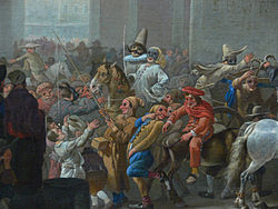
👁 Image 2 1866 cartoon by Honoré Daumier, L’Equilibre Européen, representing the balance of power as soldiers of different nations teeter the earth on bayonets The balance of power theory in international relations suggests that states may secure their survival by preventing any one state from gaining enough military power to dominate all others. If one state becomes much stronger, the theory predicts it will take advantage of its weaker neighbors, thereby driving them to unite in a defensive coalition. Some realists maintain that a balance-of-power system is more stable than one with a dominant state, as aggression is unprofitable when there is equilibrium of power between rival coalitions. When threatened, states may seek safety either by balancing, allying with others against the prevailing threat; or bandwagoning, aligning themselves with the threatening power. Other alliance tactics include buck passing and chain-ganging. Realists have long debated how the polarity of a system impacts the choice of tactics; however, it is generally agreed that in bipolar systems, each great power has no choice but to directly confront the other. Along with debates between realists about the prevalence of balancing in alliance patterns, other schools of international relations, such as constructivists, are also critical of the balance of power theory, disputing core realist assumptions regarding the international system and the behavior of states. (Full article...)
👁 Image 1866 cartoon by Honoré Daumier, L’Equilibre Européen, representing the balance of power as soldiers of different nations teeter the earth on bayonets
The balance of power theory in international relations suggests that states may secure their survival by preventing any one state from gaining enough military power to dominate all others. If one state becomes much stronger, the theory predicts it will take advantage of its weaker neighbors, thereby driving them to unite in a defensive coalition. Some realists maintain that a balance-of-power system is more stable than one with a dominant state, as aggression is unprofitable when there is equilibrium of power between rival coalitions.
When threatened, states may seek safety either by balancing, allying with others against the prevailing threat; or bandwagoning, aligning themselves with the threatening power. Other alliance tactics include buck passing and chain-ganging. Realists have long debated how the polarity of a system impacts the choice of tactics; however, it is generally agreed that in bipolar systems, each great power has no choice but to directly confront the other. Along with debates between realists about the prevalence of balancing in alliance patterns, other schools of international relations, such as constructivists, are also critical of the balance of power theory, disputing core realist assumptions regarding the international system and the behavior of states. (Full article...) -
👁 Image 3 Intangible cultural heritage (ICH)—as opposed to a place's tangible cultural heritage, cultural properties such as historic sites, monuments, and artifacts—comprises manifestations of intellectual wealth such as customs, beliefs, traditions, folklore, language, and knowledge, as expressed in particular through craftsmanship and performance. Responding to the perceived over-representation of Western Europe among World Heritage Sites, to help valorize cultural diversity, and following on from earlier related measures in Japan (1950) and in South Korea (1962), in 2001, UNESCO made a survey among states and NGOs to try to agree on a definition, and the Convention for the Safeguarding of the Intangible Cultural Heritage was drafted in 2003 for its protection and promotion. (Full article...)Intangible cultural heritage (ICH)—as opposed to a place's tangible cultural heritage, cultural properties such as historic sites, monuments, and artifacts—comprises manifestations of intellectual wealth such as customs, beliefs, traditions, folklore, language, and knowledge, as expressed in particular through craftsmanship and performance.
Responding to the perceived over-representation of Western Europe among World Heritage Sites, to help valorize cultural diversity, and following on from earlier related measures in Japan (1950) and in South Korea (1962), in 2001, UNESCO made a survey among states and NGOs to try to agree on a definition, and the Convention for the Safeguarding of the Intangible Cultural Heritage was drafted in 2003 for its protection and promotion. (Full article...) -
👁 Image 4 The League of Nations (LN or LoN; French: Société des Nations [sɔsjete de nɑsjɔ̃], SdN) was the first worldwide intergovernmental organisation whose principal mission was to maintain world peace. It was founded on 10 January 1920 by the Paris Peace Conference that ended the First World War. The main organization ceased operations on 18 April 1946 when many of its components were relocated into the new United Nations (UN) which was created in the aftermath of the Second World War. The League of Nations was the precursor organization to the United Nations. The League's primary goals were stated in its eponymous Covenant. They included preventing wars through collective security and disarmament and settling international disputes through negotiation and arbitration. Its other concerns included labour conditions, just treatment of native inhabitants, human and drug trafficking, the arms trade, global health, prisoners of war, and protection of minorities in Europe. The Covenant of the League of Nations was signed on 28 June 1919 as Part I of the Treaty of Versailles, and it became effective with the rest of the Treaty on 10 January 1920. Australia was granted the right to participate as an autonomous member nation, marking the start of Australian independence on the global stage. The first meeting of the Council of the League took place on 16 January 1920, and the first meeting of the Assembly of the League took place on 15 November 1920. In 1919, U.S. president Woodrow Wilson won the Nobel Peace Prize for his role as the leading architect of the League. Despite this, he was ultimately unsuccessful in getting his country to join it. (Full article...)
👁 Image
The League of Nations (LN or LoN; French: Société des Nations [sɔsjetedenɑsjɔ̃], SdN) was the first worldwide intergovernmental organisation whose principal mission was to maintain world peace. It was founded on 10 January 1920 by the Paris Peace Conference that ended the First World War. The main organization ceased operations on 18 April 1946 when many of its components were relocated into the new United Nations (UN) which was created in the aftermath of the Second World War. The League of Nations was the precursor organization to the United Nations.
The League's primary goals were stated in its eponymous Covenant. They included preventing wars through collective security and disarmament and settling international disputes through negotiation and arbitration. Its other concerns included labour conditions, just treatment of native inhabitants, human and drug trafficking, the arms trade, global health, prisoners of war, and protection of minorities in Europe. The Covenant of the League of Nations was signed on 28 June 1919 as Part I of the Treaty of Versailles, and it became effective with the rest of the Treaty on 10 January 1920. Australia was granted the right to participate as an autonomous member nation, marking the start of Australian independence on the global stage. The first meeting of the Council of the League took place on 16 January 1920, and the first meeting of the Assembly of the League took place on 15 November 1920. In 1919, U.S. president Woodrow Wilson won the Nobel Peace Prize for his role as the leading architect of the League. Despite this, he was ultimately unsuccessful in getting his country to join it. (Full article...) -
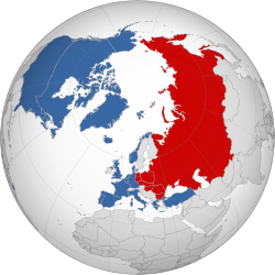
👁 Image 5 NATO and Warsaw Pact states in 1988 The Cold War was a period of international geopolitical rivalry between the United States (US) and the Soviet Union (USSR) and their respective allies, the capitalist Western Bloc and communist Eastern Bloc. It began in the aftermath of the Second World War and ended with the dissolution of the Soviet Union in 1991. The term cold war is used because there was no direct fighting between the two superpowers, though each supported opposing sides in regional conflicts known as proxy wars. In addition to the struggle for ideological and economic influence and an arms race in both conventional and nuclear weapons, the Cold War was expressed through technological rivalries such as the Space Race, espionage, propaganda campaigns, embargoes, and sports diplomacy. After the end of the Second World War in 1945, during which the US and USSR had been allies, the USSR installed satellite governments in its occupied territories in Eastern Europe and North Korea by 1949, resulting in the political division of Europe (and Germany) by an "Iron Curtain". The USSR tested its first nuclear weapon in 1949, four years after their use by the US on Hiroshima and Nagasaki, and allied with the People's Republic of China, founded in 1949. The US declared the Truman Doctrine of "containment" of communism in 1947, launched the Marshall Plan in 1948 to assist Western Europe's economic recovery, and founded the NATO military alliance in 1949 (matched by the Soviet-led Warsaw Pact in 1955). The Berlin Blockade of 1948 to 1949 was an early confrontation, as was the Korean War of 1950 to 1953, which ended in a stalemate. (Full article...)
The Cold War was a period of international geopolitical rivalry between the United States (US) and the Soviet Union (USSR) and their respective allies, the capitalist Western Bloc and communist Eastern Bloc. It began in the aftermath of the Second World War and ended with the dissolution of the Soviet Union in 1991. The term cold war is used because there was no direct fighting between the two superpowers, though each supported opposing sides in regional conflicts known as proxy wars. In addition to the struggle for ideological and economic influence and an arms race in both conventional and nuclear weapons, the Cold War was expressed through technological rivalries such as the Space Race, espionage, propaganda campaigns, embargoes, and sports diplomacy.
After the end of the Second World War in 1945, during which the US and USSR had been allies, the USSR installed satellite governments in its occupied territories in Eastern Europe and North Korea by 1949, resulting in the political division of Europe (and Germany) by an "Iron Curtain". The USSR tested its first nuclear weapon in 1949, four years after their use by the US on Hiroshima and Nagasaki, and allied with the People's Republic of China, founded in 1949. The US declared the Truman Doctrine of "containment" of communism in 1947, launched the Marshall Plan in 1948 to assist Western Europe's economic recovery, and founded the NATO military alliance in 1949 (matched by the Soviet-led Warsaw Pact in 1955). The Berlin Blockade of 1948 to 1949 was an early confrontation, as was the Korean War of 1950 to 1953, which ended in a stalemate. (Full article...) -
👁 Image 6 Human security is a paradigm for understanding global vulnerabilities whose proponents challenge the traditional notion of national security through military security by arguing that the proper referent for security should be at the human rather than the national level, and that a people- centered view of security is necessary for national, regional and global stability. The concept emerged from a multi-disciplinary understanding of security which involves a number of research fields, including development studies, international relations, strategic studies, and human rights. The United Nations Development Programme's 1994 Human Development Report is considered a milestone publication in the field of human security, with its argument that ensuring "freedom from want" and "freedom from fear" for all persons is the best path to tackle the problem of global insecurity. Critics of the concept argue that its vagueness undermines its effectiveness, that it has become little more than a vehicle for activists wishing to promote certain causes, and that it does not help the research community understand what security means or help decision-makers to formulate good policies. Alternatively, other scholars have argued that the concept of human security should be broadened to encompass military security: 'In other words, if this thing called 'human security' has the concept of 'the human' embedded at the heart of it, then let us address the question of the human condition directly. Thus understood, human security would no longer be the vague amorphous add-on to harder-edged areas of security such as military security or state security.' (Full article...)Human security is a paradigm for understanding global vulnerabilities whose proponents challenge the traditional notion of national security through military security by arguing that the proper referent for security should be at the human rather than the national level, and that a people- centered view of security is necessary for national, regional and global stability. The concept emerged from a multi-disciplinary understanding of security which involves a number of research fields, including development studies, international relations, strategic studies, and human rights. The United Nations Development Programme's 1994 Human Development Report is considered a milestone publication in the field of human security, with its argument that ensuring "freedom from want" and "freedom from fear" for all persons is the best path to tackle the problem of global insecurity.
Critics of the concept argue that its vagueness undermines its effectiveness, that it has become little more than a vehicle for activists wishing to promote certain causes, and that it does not help the research community understand what security means or help decision-makers to formulate good policies. Alternatively, other scholars have argued that the concept of human security should be broadened to encompass military security: 'In other words, if this thing called 'human security' has the concept of 'the human' embedded at the heart of it, then let us address the question of the human condition directly. Thus understood, human security would no longer be the vague amorphous add-on to harder-edged areas of security such as military security or state security.' (Full article...) -
👁 Image 7 The Vendée Globe (French: [vɑ̃de glɔb]) is a single-handed (solo) non-stop, unassisted round the world yacht race. The race was founded by Philippe Jeantot in 1989, and since 1992 has taken place every four years. It is named after the department of Vendée, in France, where the race starts and ends. The Vendée Globe is considered an extreme quest of individual endurance and the ultimate test in ocean racing. (Full article...)The Vendée Globe (French: [vɑ̃deglɔb]) is a single-handed (solo) non-stop, unassisted round the world yacht race. The race was founded by Philippe Jeantot in 1989, and since 1992 has taken place every four years. It is named after the department of Vendée, in France, where the race starts and ends. The Vendée Globe is considered an extreme quest of individual endurance and the ultimate test in ocean racing. (Full article...)
.svg)
.svg)
General images - load new batch
-
Cuneiform inscription, eastern Turkey
-
Last Moon landing: Apollo 17 (1972)
-
👁 Image 3An impression of the Archean, the eon after Earth's formation, featuring round stromatolites, which are early oxygen-producing forms of life from billions of years ago. After the Late Heavy Bombardment, Earth's crust had cooled, its water-rich barren surface is marked by continents and volcanoes, with the Moon still orbiting Earth half as far as it is today, appearing 2.8 times larger and producing strong tides. (from Earth)An impression of the Archean, the eon after Earth's formation, featuring round stromatolites, which are early oxygen-producing forms of life from billions of years ago. After the Late Heavy Bombardment, Earth's crust had cooled, its water-rich barren surface is marked by continents and volcanoes, with the Moon still orbiting Earth half as far as it is today, appearing 2.8 times larger and producing strong tides. (from Earth)
-
Geologic map of North America, color-coded by age. From most recent to oldest, age is indicated by yellow, green, blue, and red. The reds and pinks indicate rock from the Archean.
-
👁 Image 5Earth's history with time-spans of the eons to scale. Ma means "million years ago", Ga means "billion years ago". (from History of Earth)Earth's history with time-spans of the eons to scale. Ma means "million years ago", Ga means "billion years ago". (from History of Earth)
-
Battle during the 1281 Mongol invasion of Japan
-
Machu Picchu, Inca Empire, Peru
-
👁 Image 8Artist's impression of the enormous collision that probably formed the Moon (from History of Earth)Artist's impression of the enormous collision that probably formed the Moon (from History of Earth)
-
The first airplane, the Wright Flyer, flew on 17 December 1903.
-
👁 The graph from 1880 to 2020 shows natural drivers exhibiting fluctuations of about 0.3 degrees Celsius. Human drivers steadily increase by 0.3 degrees over 100 years to 1980, then steeply by 0.8 degrees more over the past 40 years.Change in average surface air temperature and drivers for that change. Human activity has caused increased temperatures, with natural forces adding some variability. (from Earth)
-
Japanese depiction of a Portuguese carrack, a result of globalizing maritime trade
-
👁 Image 13Earth's night-side upper atmosphere appearing from the bottom as bands of afterglow illuminating the troposphere in orange with silhouettes of clouds, and the stratosphere in white and blue. Next the mesosphere (pink area) extends to the orange and faintly green line of the lowest airglow, at about one hundred kilometers at the edge of space and the lower edge of the thermosphere (invisible). Continuing with green and red bands of aurorae stretching over several hundred kilometers. (from Earth)Earth's night-side upper atmosphere appearing from the bottom as bands of afterglow illuminating the troposphere in orange with silhouettes of clouds, and the stratosphere in white and blue. Next the mesosphere (pink area) extends to the orange and faintly green line of the lowest airglow, at about one hundred kilometers at the edge of space and the lower edge of the thermosphere (invisible). Continuing with green and red bands of aurorae stretching over several hundred kilometers. (from Earth)
-
👁 Image 14Dinosaurs were the dominant terrestrial vertebrates throughout most of the Mesozoic (from History of Earth)Dinosaurs were the dominant terrestrial vertebrates throughout most of the Mesozoic (from History of Earth)
-
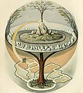
👁 Image 16Yggdrasil, an attempt to reconstruct the Norse world tree which connects the heavens, the world, and the underworld. (from World)Yggdrasil, an attempt to reconstruct the Norse world tree which connects the heavens, the world, and the underworld. (from World)
-
A reconstruction of Pannotia (550 Ma). (from History of Earth)
-
👁 Image 18Portrait of Alfraganus in the Compilatio astronomica, 1493. Islamic astronomers began just before the 9th century to collect and translate Indian, Persian and Greek astronomical texts, adding their own astronomy and enabling later, particularly European astronomy to build on. Symbolic for the post-classical period, a period of an increasing trans-regional literary culture, particularly in the sciences, spreading and building on methods of science. (from Human history)Portrait of Alfraganus in the Compilatio astronomica, 1493. Islamic astronomers began just before the 9th century to collect and translate Indian, Persian and Greek astronomical texts, adding their own astronomy and enabling later, particularly European astronomy to build on. Symbolic for the post-classical period, a period of an increasing trans-regional literary culture, particularly in the sciences, spreading and building on methods of science. (from Human history)
-
👁 Three large pyramids in the desert, together with subsidiary pyramids and the remains of other structures (from Human history)Great Pyramids of Giza, Egypt
-
👁 Image 20Artist's impression of a Hadean landscape with the relatively newly formed Moon still looming closely over Earth and both bodies sustaining strong volcanism. (from History of Earth)Artist's impression of a Hadean landscape with the relatively newly formed Moon still looming closely over Earth and both bodies sustaining strong volcanism. (from History of Earth)
-
👁 Image 22A view of Earth with different layers of its atmosphere visible: the troposphere with its clouds casting shadows, a band of stratospheric blue sky at the horizon, and a line of green airglow of the lower thermosphere around an altitude of 100 km, at the edge of space (from Earth)A view of Earth with different layers of its atmosphere visible: the troposphere with its clouds casting shadows, a band of stratospheric blue sky at the horizon, and a line of green airglow of the lower thermosphere around an altitude of 100 km, at the edge of space (from Earth)
-
Satellite time lapse imagery of Earth's rotation showing axis tilt (from Earth)
-
Chloroplasts in the cells of a moss (from History of Earth)
-
👁 Image 26Pangaea was a supercontinent that existed from about 300 to 180 Ma. The outlines of the modern continents and other landmasses are indicated on this map. (from History of Earth)Pangaea was a supercontinent that existed from about 300 to 180 Ma. The outlines of the modern continents and other landmasses are indicated on this map. (from History of Earth)
-
A pillar at Neolithic Göbekli Tepe
-
👁 Image 28Pale orange dot, an impression of Early Earth, featuring its tinted orange methane-rich early atmosphere (from Earth)Pale orange dot, an impression of Early Earth, featuring its tinted orange methane-rich early atmosphere (from Earth)
-
Image of the physical world, captured by the Hubble Space Telescope (from World)
-
👁 Image 31Vitruvian Man, c. 1490 by Leonardo da Vinci, epitomizes the advances in art and science seen during the Renaissance. (from History of Earth)Vitruvian Man, c. 1490 by Leonardo da Vinci, epitomizes the advances in art and science seen during the Renaissance. (from History of Earth)
-
Cross-section through a liposome (from History of Earth)
-
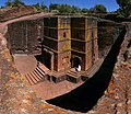
👁 Image 33One of the eleven Rock-hewn Churches of Lalibela constructed during the Zagwe dynasty in Ethiopia (from Human history)One of the eleven Rock-hewn Churches of Lalibela constructed during the Zagwe dynasty in Ethiopia (from Human history)
-
👁 Image 34The pale orange dot, an artist's impression of the early Earth which might have appeared orange through its hazy methane rich prebiotic second atmosphere. Earth's atmosphere at this stage was somewhat comparable to today's atmosphere of Titan. (from History of Earth)The pale orange dot, an artist's impression of the early Earth which might have appeared orange through its hazy methane rich prebiotic second atmosphere. Earth's atmosphere at this stage was somewhat comparable to today's atmosphere of Titan. (from History of Earth)
-
Pillar erected by Ashoka, a Mauryan Emperor in India
-
👁 Image 36Artist's conception of Hadean Eon Earth, when it was much hotter and inhospitable to all forms of life. (from History of Earth)Artist's conception of Hadean Eon Earth, when it was much hotter and inhospitable to all forms of life. (from History of Earth)
-
👁 Image 37A depiction of the early Solar System's protoplanetary disk from which Earth and other Solar System bodies were formed (from Earth)A depiction of the early Solar System's protoplanetary disk from which Earth and other Solar System bodies were formed (from Earth)
-
👁 Image 38A banded iron formation from the 3.15 Ga Moodies Group, Barberton Greenstone Belt, South Africa. Red layers represent the times when oxygen was available; gray layers were formed in anoxic circumstances. (from History of Earth)A banded iron formation from the 3.15 Ga Moodies Group, Barberton Greenstone Belt, South Africa. Red layers represent the times when oxygen was available; gray layers were formed in anoxic circumstances. (from History of Earth)
-
👁 Diagram showing the magnetic field lines of Earth's magnetosphere. The lines are swept back in the anti-solar direction under the influence of the solar wind.A schematic view of Earth's magnetosphere with solar wind flowing from left to right (from Earth)
-
👁 Image 40Tiktaalik, a fish with limb-like fins and a predecessor of tetrapods. Reconstruction from fossils about 375 million years old. (from History of Earth)Tiktaalik, a fish with limb-like fins and a predecessor of tetrapods. Reconstruction from fossils about 375 million years old. (from History of Earth)
-
👁 Image 42A computer-generated image mapping the prevalence of artificial satellites and space debris around Earth in geosynchronous and low Earth orbit (from Earth)A computer-generated image mapping the prevalence of artificial satellites and space debris around Earth in geosynchronous and low Earth orbit (from Earth)
-
👁 Image 43Earth's western hemisphere showing topography relative to Earth's center instead of to mean sea level, as in common topographic maps (from Earth)Earth's western hemisphere showing topography relative to Earth's center instead of to mean sea level, as in common topographic maps (from Earth)
-
👁 Image 44A map of heat flow from Earth's interior to the surface of Earth's crust, mostly along the oceanic ridges (from Earth)A map of heat flow from Earth's interior to the surface of Earth's crust, mostly along the oceanic ridges (from Earth)
-
A composite image of artificial light emissions at night on a map of Earth (from Earth)
-
Earth's land use for human agriculture in 2019 (from Earth)
-
An artist's impression of ice age Earth at glacial maximum. (from History of Earth)
-
Fall of the Berlin Wall, 1989
-
👁 Image 51A composite image of Earth, with its different types of surface discernible: Earth's surface dominating Ocean (blue), Africa with lush (green) to dry (brown) land and Earth's polar ice in the form of Antarctic sea ice (grey) covering the Antarctic or Southern Ocean and the Antarctic ice sheet (white) covering Antarctica. (from Earth)A composite image of Earth, with its different types of surface discernible: Earth's surface dominating Ocean (blue), Africa with lush (green) to dry (brown) land and Earth's polar ice in the form of Antarctic sea ice (grey) covering the Antarctic or Southern Ocean and the Antarctic ice sheet (white) covering Antarctica. (from Earth)
-
Carving of Persian and Median soldiers, Persepolis, Achaemenid Empire, 5th century BCE
-
👁 Image 54Lithified stromatolites on the shores of Lake Thetis, Western Australia. Archean stromatolites are the first direct fossil traces of life on Earth. (from History of Earth)Lithified stromatolites on the shores of Lake Thetis, Western Australia. Archean stromatolites are the first direct fossil traces of life on Earth. (from History of Earth)
-
A reconstruction of human history based on fossil data. (from History of Earth)
-
👁 Image 56Trilobites first appeared during the Cambrian period and were among the most widespread and diverse groups of Paleozoic organisms. (from History of Earth)Trilobites first appeared during the Cambrian period and were among the most widespread and diverse groups of Paleozoic organisms. (from History of Earth)
-
Chennakesava Temple, Belur, India
-
Notre-Dame de Paris, France
-
👁 Image 59A 580 million year old fossil of Spriggina floundensi, an animal from the Ediacaran period. Such life forms could have been ancestors to the many new forms that originated in the Cambrian Explosion. (from History of Earth)A 580 million year old fossil of Spriggina floundensi, an animal from the Ediacaran period. Such life forms could have been ancestors to the many new forms that originated in the Cambrian Explosion. (from History of Earth)
-
👁 Image 60Successive dispersals of Homo erectus (yellow), Homo neanderthalensis (ochre) during Out of Africa I and Homo sapiens (red, Out of Africa II), with the numbers of years since they appeared before present. (from Human history)Successive dispersals of Homo erectus (yellow), Homo neanderthalensis (ochre) during Out of Africa I and Homo sapiens (red, Out of Africa II), with the numbers of years since they appeared before present. (from Human history)
-
European migrations by mostly Germanic peoples, 2nd–6th centuries (from Human history)
-
Benin Bronze head from Nigeria
-
👁 A miniature depicting a tonsured man, a fully armored man wearing a shield, and a man who holds a spade (from Human history)13th-century French historiated initial with the three classes of medieval society: those who prayed (the clergy), those who fought (the knights), and those who worked (the peasantry)
-
👁 Image 64Earth's axial tilt causing different angles of seasonal illumination at different orbital positions around the Sun (from Earth)Earth's axial tilt causing different angles of seasonal illumination at different orbital positions around the Sun (from Earth)
-
👁 Image 66Artist's impression of Earth during the later Archean, the largely cooled planetary crust and water-rich barren surface, marked by volcanoes and continents, features already round microbialites. The Moon, still orbiting Earth much closer than today and still dominating Earth's sky, produced strong tides. (from History of Earth)Artist's impression of Earth during the later Archean, the largely cooled planetary crust and water-rich barren surface, marked by volcanoes and continents, features already round microbialites. The Moon, still orbiting Earth much closer than today and still dominating Earth's sky, produced strong tides. (from History of Earth)
-
👁 Image 69Graph showing range of estimated partial pressure of atmospheric oxygen through geologic time (from History of Earth)Graph showing range of estimated partial pressure of atmospheric oxygen through geologic time (from History of Earth)
-
Obelisk of Axum, Ethiopia
-
Olmec colossal head, now at the Museo de Antropología de Xalapa
-
👁 Image 72Artist's rendition of an oxinated fully-frozen Snowball Earth with no remaining liquid surface water. (from History of Earth)Artist's rendition of an oxinated fully-frozen Snowball Earth with no remaining liquid surface water. (from History of Earth)
-
👁 Image 73An animation of the changing density of productive vegetation on land (low in brown; heavy in dark green) and phytoplankton at the ocean surface (low in purple; high in yellow) (from Earth)An animation of the changing density of productive vegetation on land (low in brown; heavy in dark green) and phytoplankton at the ocean surface (low in purple; high in yellow) (from Earth)
-
👁 Image 75A view of Earth with its global ocean and cloud cover, which dominate Earth's surface and hydrosphere; at Earth's polar regions, its hydrosphere forms larger areas of ice cover. (from Earth)A view of Earth with its global ocean and cloud cover, which dominate Earth's surface and hydrosphere; at Earth's polar regions, its hydrosphere forms larger areas of ice cover. (from Earth)
-
An artist's rendering of a protoplanetary disk (from History of Earth)
-
👁 Image 77The replicator in virtually all known life is deoxyribonucleic acid. DNA is far more complex than the original replicator and its replication systems are highly elaborate. (from History of Earth)The replicator in virtually all known life is deoxyribonucleic acid. DNA is far more complex than the original replicator and its replication systems are highly elaborate. (from History of Earth)
-
Artist's conception of Devonian flora (from History of Earth)
-
Florence, birthplace of the Italian Renaissance
-
Angkor Wat temple complex, Cambodia, early 12th century
-
Standing Buddha from Gandhara, 2nd century CE
-
Ming dynasty section, Great Wall of China
-
Taj Mahal, Mughal Empire, India
-
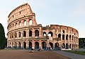
The Colosseum in Rome (from Human history)
-
COVID-19 pandemic, 2020 (from Human history)
.png)
.jpg)
.svg)
.jpg)
.jpeg)
Megacities of the world - show another
São Paulo (/ˌsaʊ(m)ˈpaʊloʊ/; Portuguese: [sɐ̃wˈpawlu] ⓘ; Portuguese for 'Saint Paul') is the capital city of the state of São Paulo, as well as the most populous city in Brazil and South America. The city exerts international influence in commerce, finance, culture, gastronomy, arts, fashion, technology, entertainment and media, having been listed by UNESCO's Creative Cities Network as a "City of Film" and the title of "World Capital of Gastronomy", and by the Globalization and World Cities Research Network (GaWC) as an alpha global city. It is the largest urban area by population outside Asia and the most populous Portuguese-speaking city in the world. The city's name "São Paulo" honors Paul the Apostle and people from the city are known as paulistanos. The city's Latin motto is Non ducor, duco, which translates as "I am not led, I lead".
Founded in 1554 by Jesuit priests, São Paulo is one of the oldest continuously inhabited cities on the American continent. It played a strategic role during the Brazilian colonial period, serving as the center and starting point for the expeditions of the Paulista bandeirantes (pioneers) settlers for the territorial and economic expansion of the country; however, its economic opulence was consolidated during the Brazilian coffee cycle in the mid-19th century. From that period onward, it became the stage for landmark events in Brazilian history, such as the Cry of Ipiranga, the Modern Art Week, the 1932 Revolution, and the Diretas Já (Direct Elections Now) movement. In the 20th century, it consolidated its role as the main national economic hub with industrialization in Brazil, which made the city a cosmopolitan melting pot, home to the largest Arab, Italian, and Japanese diasporas in the world, with ethnic neighborhoods like Bixiga, Bom Retiro, and Liberdade, and people from more than 200 other countries. The city's metropolitan area, Greater São Paulo, is home to more than 20 million inhabitants and ranks as the most populous in Brazil and one of the most populous in the world. The process of conurbation between the metropolitan areas around Greater São Paulo also created the São Paulo Macrometropolis, the first megalopolis in the Southern Hemisphere, with more than 30 million inhabitants. (Full article...)
Did you know - load new batch
- ... that the Hotel Normandie supported the Leaders of the World?
- ... that English missionary Reverend Thomas Sparshott co-wrote a book in Swahili, and his daughter Margaret Elwyn Sparshott was responsible as matron for 22 hospitals in World War I?
- ... that King Hussein of Jordan gifted an ancient Roman column to New York City for the 1964–65 World's Fair?
- ... that Patrick Gottsch, the founder of RFD-TV and The Cowboy Channel, led the effort to break the Guinness World Record for the largest parade of pickup trucks?
- ... that Alexander Langmuir created the Epidemic Intelligence Service to send epidemiologists across the world?
- ... that Actinote zikani is one of only two butterflies on the IUCN's list of the 100 most threatened species?
- ... that after losing a Shanghai mansion to the Empire of Japan in World War II, British hotelier Victor Sassoon abandoned repossession plans following a communist takeover?
- ... that Femke Bol's time of [[2024 World Athletics Indoor Championships –
Countries of the world - show another
Armenia, officially the Republic of Armenia, is a landlocked country in the Armenian highlands of West Asia. It is a part of the Caucasus region and is bordered by Turkey to the west, Georgia to the north, Azerbaijan to the east, and Iran and the Azerbaijani exclave of Nakhchivan to the south. Yerevan is the capital, largest city and financial center.
The Armenian highlands have been home to the Hayasa-Azzi, Shupria, and Nairi peoples. By at least 600 BC, an archaic form of Proto-Armenian, an Indo-European language, had diffused into the Armenian highlands. The first Armenian state of Urartu was established in 860 BC, and by the 6th century BC it was replaced by the Satrapy of Armenia. The Kingdom of Armenia reached its height under Tigranes the Great in the 1st century BC and in AD 301 became the first state in the world to adopt Christianity as its official religion. Armenia still recognises the Armenian Apostolic Church, the world's oldest national church, as the country's primary religious establishment. The ancient Armenian kingdom was split between the Byzantine and Sasanian Empires around the early 5th century. Under the Bagratuni dynasty, the Bagratid Kingdom of Armenia was restored in the 9th century before falling in 1045. Cilician Armenia, an Armenian principality and later a kingdom, was located on the coast of the Mediterranean Sea between the 11th and 14th centuries. (Full article...)
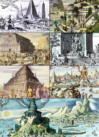
Various lists of the Wonders of the World have been compiled from antiquity to the present day, in order to catalogue the world's most spectacular natural features and human-built structures.
The Seven Wonders of the Ancient World is the oldest known list of this type, documenting the most iconic and remarkable human-made creations of classical antiquity; the canonical list was established in the 1572 Octo Mundi Miracula, based on classical sources which varied widely. The classical sources only include works located around the Mediterranean rim and in the ancient Near East. The number seven was chosen because the Greeks believed it represented perfection and plenty, and because it reflected the number of planets known in ancient times (five) plus the Sun and Moon. (Full article...)
Related portals
.svg)
.svg)
.svg)
.svg)
.jpg)
Protected areas of the world - load new batch
-
👁 Image 1 Protected areas of Eswatini include any geographical area protected for a specific use inside the landlocked country of Eswatini, in southern Africa. Within Eswatini there is a mix of national, private and community-owned protected areas. They include national parks, nature reserves, wildlife sanctuaries and game reserves. (Full article...)Protected areas of Eswatini include any geographical area protected for a specific use inside the landlocked country of Eswatini, in southern Africa.
Within Eswatini there is a mix of national, private and community-owned protected areas. They include national parks, nature reserves, wildlife sanctuaries and game reserves. (Full article...) -
👁 Image 2 Flamingos at the Ras Al Khor Wildlife Sanctuary This is a list of protected areas of United Arab Emirates: Abu Dhabi Mangrove and Coastal Wetland Reserve Ain al Faydah National Park Al Awir Nature Reserve Al Khawanij Nature Reserve Al Maha Nature Reserve Al Marmoom Desert Conservation Reserve Al Wohoosh Desert Conservation Reserve Dubai Desert Conservation Reserve National Park Hatta Nature Reserve Jabal Ali Wildlife Sanctuary Khor Kalba Nature Reserve Marawah Marine Protected Area Mushrif National Park Nadd Al Sheba Nature Reserve Rams Lagoon Reserve Ras Al Khor Wildlife Sanctuary Wadi Wurayah National Park Zirkuh Island Bird Sanctuary (Full article...)
👁 Image Flamingos at the Ras Al Khor Wildlife Sanctuary
This is a list of protected areas of United Arab Emirates:- Abu Dhabi Mangrove and Coastal Wetland Reserve
- Ain al Faydah National Park
- Al Awir Nature Reserve
- Al Khawanij Nature Reserve
- Al Maha Nature Reserve
- Al Marmoom Desert Conservation Reserve
- Al Wohoosh Desert Conservation Reserve
- Dubai Desert Conservation Reserve National Park
- Hatta Nature Reserve
- Jabal Ali Wildlife Sanctuary
- Khor Kalba Nature Reserve
- Marawah Marine Protected Area
- Mushrif National Park
- Nadd Al Sheba Nature Reserve
- Rams Lagoon Reserve
- Ras Al Khor Wildlife Sanctuary
- Wadi Wurayah National Park
- Zirkuh Island Bird Sanctuary
-
👁 Image 3 This is a list of protected areas of Cambodia. A total of 8 forms of protected areas are recognized under the Cambodian Protected Area Law of 2008. These are: (Full article...)This is a list of protected areas of Cambodia.
A total of 8 forms of protected areas are recognized under the Cambodian Protected Area Law of 2008. These are: (Full article...) -
👁 Image 4 The protected areas of Bhutan are its national parks, nature preserves, and wildlife sanctuaries. Most of these protected areas were first set aside in the 1960s, originally covering most of the northern and southern regions of Bhutan. Today, protected areas cover more than 42% of the kingdom, mostly in the northern regions. Protected areas also line most of Bhutan's international borders with China and India. (Full article...)
👁 Image
The protected areas of Bhutan are its national parks, nature preserves, and wildlife sanctuaries. Most of these protected areas were first set aside in the 1960s, originally covering most of the northern and southern regions of Bhutan. Today, protected areas cover more than 42% of the kingdom, mostly in the northern regions. Protected areas also line most of Bhutan's international borders with China and India. (Full article...) -
👁 Image 5 Protected areas of the Caribbean are significant in a region of particular ecological vulnerability, including the impact of climate change and the impact of tourism. The University of the West Indies' "Caribbean Protected Areas Gateway" supports informational resources for the 16 Caribbean member states of the Organisation of African, Caribbean and Pacific States. It forms the regional component of the ACP's Biodiversity and Protected Areas Management program, building on the World Database on Protected Areas. (Full article...)Protected areas of the Caribbean are significant in a region of particular ecological vulnerability, including the impact of climate change and the impact of tourism.
The University of the West Indies' "Caribbean Protected Areas Gateway" supports informational resources for the 16 Caribbean member states of the Organisation of African, Caribbean and Pacific States. It forms the regional component of the ACP's Biodiversity and Protected Areas Management program, building on the World Database on Protected Areas. (Full article...) -
👁 Image 6 The mountain of Stob Binnein lies in the Loch Lomond and The Trossachs National Park. Many parts of Scotland are protected in accordance with a number of national and international designations because of their environmental, historical or cultural value. Protected areas can be divided according to the type of resource which each seeks to protect. NatureScot has various roles in the delivery of many environmental designations in Scotland, i.e. those aimed at protecting flora and fauna, scenic qualities and geological features. Historic Environment Scotland is responsible for designations that protect sites of historic and cultural importance. Some international designations, such as World Heritage Sites, can cover both categories of site. The various designations overlap considerably with many protected areas being covered by multiple designations with different boundaries. (Full article...)
👁 Image The mountain of Stob Binnein lies in the Loch Lomond and The Trossachs National Park.
Many parts of Scotland are protected in accordance with a number of national and international designations because of their environmental, historical or cultural value. Protected areas can be divided according to the type of resource which each seeks to protect. NatureScot has various roles in the delivery of many environmental designations in Scotland, i.e. those aimed at protecting flora and fauna, scenic qualities and geological features. Historic Environment Scotland is responsible for designations that protect sites of historic and cultural importance. Some international designations, such as World Heritage Sites, can cover both categories of site.
The various designations overlap considerably with many protected areas being covered by multiple designations with different boundaries. (Full article...) -
👁 Image 7 The protected areas of South Africa include national parks and marine protected areas managed by the national government, public nature reserves managed by provincial and local governments, and private nature reserves managed by private landowners. Most protected areas are intended for the conservation of flora and fauna. National parks are maintained by South African National Parks (SANParks). A number of national parks have been incorporated in transfrontier conservation areas. Protected areas may also be protected for their value and importance as historical, cultural heritage or scientific sites. More information on these can be found in the list of heritage sites in South Africa. (Full article...)The protected areas of South Africa include national parks and marine protected areas managed by the national government, public nature reserves managed by provincial and local governments, and private nature reserves managed by private landowners. Most protected areas are intended for the conservation of flora and fauna. National parks are maintained by South African National Parks (SANParks). A number of national parks have been incorporated in transfrontier conservation areas.
Protected areas may also be protected for their value and importance as historical, cultural heritage or scientific sites. More information on these can be found in the list of heritage sites in South Africa. (Full article...) -
👁 Image 8 Emerald Network of Ukraine [uk] in 2019, the Ukrainian equivalent of Natura 2000, both part of the Emerald network of the Berne Convention on the Conservation of European Wildlife and Natural Habitats. Protected areas of Ukraine (Ukrainian: охоронні території) are special areas of Ukraine established with the goal of protecting the natural and cultural heritage of the country from excessive changes as a result of human activity. The protection of the areas is the responsibility of the government of Ukraine, specifically the Cabinet of Ministers of Ukraine. Ukraine has several categories of protected areas of Ukraine and the protected areas include: (Full article...)
👁 Image Emerald Network of Ukraine [uk] in 2019, the Ukrainian equivalent of Natura 2000, both part of the Emerald network of the Berne Convention on the Conservation of European Wildlife and Natural Habitats.
Protected areas of Ukraine (Ukrainian: охоронні території) are special areas of Ukraine established with the goal of protecting the natural and cultural heritage of the country from excessive changes as a result of human activity. The protection of the areas is the responsibility of the government of Ukraine, specifically the Cabinet of Ministers of Ukraine.
Ukraine has several categories of protected areas of Ukraine and the protected areas include: (Full article...) -
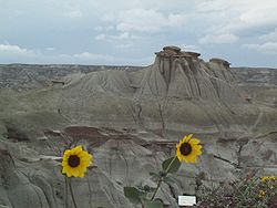
👁 Image 9 Dinosaur Provincial Park This is a list of protected areas of Alberta. Protected areas are managed by the Government of Canada or the Government of Alberta. The provincial government owns 60% of Alberta's landmass but most of this has not been formally protected. The total protected area throughout Alberta including federal and provincial protected areas is approximately 90,700 km2 (35,000 sq mi). (Full article...)
👁 Image Dinosaur Provincial Park
This is a list of protected areas of Alberta. Protected areas are managed by the Government of Canada or the Government of Alberta. The provincial government owns 60% of Alberta's landmass but most of this has not been formally protected. The total protected area throughout Alberta including federal and provincial protected areas is approximately 90,700 km2 (35,000 sq mi). (Full article...) -
👁 Image 10 Protected areas of Norway include: National parks of Norway About 17 percent of the mainland of Norway is protected. Of this, ca. 8.3 percent is national parks, 1.3 percent is nature reserves and 4.7 percent otherwise protected. (Full article...)Protected areas of Norway include:
About 17 percent of the mainland of Norway is protected. Of this, ca. 8.3 percent is national parks, 1.3 percent is nature reserves and 4.7 percent otherwise protected. (Full article...) -
👁 Image 11 Ludaš Lake is a shallow lake in the province of Vojvodina in northern Serbia, near the city of Subotica. It is a special natural preserve and, since 1977, designated as a swamp area of international significance by the Ramsar Convention. Protected areas cover around 5% of the territory of Serbia. The Law on the Protection of the Nature defines these categories of protected areas: Strict nature reserve — Area of unmodified natural features with representative ecosystems set aside for the preservation of its biodiversity and for scientific research and monitoring. Special nature reserve — Area of unmodified or slightly modified natural features of great importance due to uniqueness and rarity which includes the habitats of endangered species set aside for the preservation of its unique features, education, limited tourism and for scientific research and monitoring. National park — Area with large number of diverse ecosystems of national value, with outstanding natural features and/or cultural heritage set aside for the preservation of its natural resources and for educational, scientific and tourist use. Natural monument — Small unmodified or slightly modified natural feature, object or phenomenon, easily detectable and unique, with unique natural attributes. Protected habitat — Area which includes habitats of one or more wildlife species. Landscape of outstanding features — Area of remarkable appearance with important natural and cultural value. Nature park — Area of well-preserved natural values with preserved natural ecosystems and picturesque landscape set aside for the preservation of biodiversity and for educational, tourist, recreational and scientific use. (Full article...)
👁 Image Ludaš Lake is a shallow lake in the province of Vojvodina in northern Serbia, near the city of Subotica. It is a special natural preserve and, since 1977, designated as a swamp area of international significance by the Ramsar Convention.
Protected areas cover around 5% of the territory of Serbia. The Law on the Protection of the Nature defines these categories of protected areas:- Strict nature reserve — Area of unmodified natural features with representative ecosystems set aside for the preservation of its biodiversity and for scientific research and monitoring.
- Special nature reserve — Area of unmodified or slightly modified natural features of great importance due to uniqueness and rarity which includes the habitats of endangered species set aside for the preservation of its unique features, education, limited tourism and for scientific research and monitoring.
- National park — Area with large number of diverse ecosystems of national value, with outstanding natural features and/or cultural heritage set aside for the preservation of its natural resources and for educational, scientific and tourist use.
- Natural monument — Small unmodified or slightly modified natural feature, object or phenomenon, easily detectable and unique, with unique natural attributes.
- Protected habitat — Area which includes habitats of one or more wildlife species.
- Landscape of outstanding features — Area of remarkable appearance with important natural and cultural value.
- Nature park — Area of well-preserved natural values with preserved natural ecosystems and picturesque landscape set aside for the preservation of biodiversity and for educational, tourist, recreational and scientific use.
-
👁 Image 12 Protected areas of Sri Lanka are administrated by Department of Forest Conservation and Department of Wildlife Conservation of Sri Lanka.There are 501 protected areas in Sri Lanka. The protected areas that fall under supervision of the Department of Forest Conservation include forests defined in National Heritage Wilderness Area Act in 1988, forest reservations, and forests managed for sustainability. Sinharaja Forest Reserve is an example for a National Heritage forest (it is also a World Heritage Site). There are 32 forests categorized as conservation forests including Knuckles Mountain Range. Strict nature reserves, national parks, nature reserves, forest corridors, and sanctuaries recognized under the Flora and Fauna Protection Ordinance are managed by Department of Wildlife Conservation. Total of all protected areas is 1,767,000 ha. Protected areas in Sri Lanka account for 26.5 percent of the total area. This is a higher percentage of protected areas than in all of Asia and much of the World. (Full article...)Protected areas of Sri Lanka are administrated by Department of Forest Conservation and Department of Wildlife Conservation of Sri Lanka.There are 501 protected areas in Sri Lanka. The protected areas that fall under supervision of the Department of Forest Conservation include forests defined in National Heritage Wilderness Area Act in 1988, forest reservations, and forests managed for sustainability. Sinharaja Forest Reserve is an example for a National Heritage forest (it is also a World Heritage Site). There are 32 forests categorized as conservation forests including Knuckles Mountain Range. Strict nature reserves, national parks, nature reserves, forest corridors, and sanctuaries recognized under the Flora and Fauna Protection Ordinance are managed by Department of Wildlife Conservation. Total of all protected areas is 1,767,000 ha. Protected areas in Sri Lanka account for 26.5 percent of the total area. This is a higher percentage of protected areas than in all of Asia and much of the World. (Full article...)
-
👁 Image 13 Viru bog in Lahemaa National Park Protected areas in Estonia are national parks, nature reserves and landscape protection areas (nature parks). Estonia has five national parks, 167 nature reserves and 152 landscape conservation areas. In addition, there are 116 (118) protected areas with an old (Soviet-era) protection regulation and 537 parks. In total, 18.1% of Estonia are protected nature areas, with Lääne County having the highest percentage (32%) and Põlva County the lowest percentage of protected areas, about 9%. (Full article...)
👁 Image Viru bog in Lahemaa National Park
Protected areas in Estonia are national parks, nature reserves and landscape protection areas (nature parks).
Estonia has five national parks, 167 nature reserves and 152 landscape conservation areas. In addition, there are 116 (118) protected areas with an old (Soviet-era) protection regulation and 537 parks. In total, 18.1% of Estonia are protected nature areas, with Lääne County having the highest percentage (32%) and Põlva County the lowest percentage of protected areas, about 9%. (Full article...) -
👁 Image 14 Protected areas of Turkmenistan include nine nature reserves (zapovednik) and 13 sanctuaries (zakaznik) with a total area of 19,750 km2 or more than 4% of Turkmenistan's territory. (Full article...)Protected areas of Turkmenistan include nine nature reserves (zapovednik) and 13 sanctuaries (zakaznik) with a total area of 19,750 km2 or more than 4% of Turkmenistan's territory. (Full article...)
-
👁 Image 15 The state of Johor in Malaysia is noted for its national parks and forest reserves which preserve virgin rainforests known for its biodiversity and endangered species of animals. Mangrove swamps and coral reefs are also protected within these parks. (Full article...)The state of Johor in Malaysia is noted for its national parks and forest reserves which preserve virgin rainforests known for its biodiversity and endangered species of animals.
Mangrove swamps and coral reefs are also protected within these parks. (Full article...)
Selected world maps
-
👁 Image 1The world map by Gerardus Mercator (1569), the first map in the well-known Mercator projectionThe world map by Gerardus Mercator (1569), the first map in the well-known Mercator projection
-
United Nations Human Development Index map by country (2016)
-
👁 Image 3The Goode homolosine projection is a pseudocylindrical, equal-area, composite map projection used for world maps.The Goode homolosine projection is a pseudocylindrical, equal-area, composite map projection used for world maps.
-
Index map from the International Map of the World (1:1,000,000 scale)
-
1516 map of the world by Martin Waldseemüller
-
A plate tectonics map with volcano locations indicated with red circles
-
Time zones of the world
-
Mollweide projection of the world
-
👁 Image 9Only a few of the largest large igneous provinces appear (coloured dark purple) on this geological map, which depicts crustal geologic provinces as seen in seismic refraction dataOnly a few of the largest large igneous provinces appear (coloured dark purple) on this geological map, which depicts crustal geologic provinces as seen in seismic refraction data
World records
- List of Olympic records in athletics
- List of world records in athletics
- List of junior world records in athletics
- List of world records in masters athletics
- List of world youth bests in athletics
- List of IPC world records in athletics
- List of world records in canoeing
- List of world records in chess
- List of cycling records
- List of world records in track cycling
- List of world records in finswimming
- List of world records in juggling
- List of world records in rowing
- List of world records in speed skating
- List of world records in swimming
- List of IPC world records in swimming
- List of world records in Olympic weightlifting
Topics
.jpg)
Categories
Wikimedia
The following Wikimedia Foundation sister projects provide more on this subject:
-
Commons
Free media repository -
Wikibooks
Free textbooks and manuals -
Wikidata
Free knowledge base -
Wikinews
Free-content news -
Wikiquote
Collection of quotations -
Wikisource
Free-content library -
Wikispecies
Directory of species -
Wikiversity
Free learning tools -
Wikivoyage
Free travel guide -
Wiktionary
Dictionary and thesaurus
More portals
- Pages with French IPA
- Pages using the Phonos extension
- Portals with undated maintenance templates
- Manually maintained portal pages with no date
- All manually maintained portal pages
- Portals with triaged subpages
- All portals with triaged subpages
- Portals with named maintainer
- Automated article-slideshow portals with 201–500 articles in article list
- Pages with Portuguese IPA
- Pages including recorded pronunciations
- Pages with Langnf omitting second positional parameter
- Automated article-slideshow portals with 101–200 articles in article list
- Portals needing placement of incoming links